EXISTING SHORELINE CONDITIONS STUDY EAO Condition 39

The full pdf of this report is contained in this pdf:
BC EAO Condition 39 Exisitng Shoreline Conditions Report – May 2023 – for engagement

The purpose of this posting is to reference the part of the report referring to Metchosin’s coastline  and to provide comment on it.

===========================================================

From page 4 of the REPORT:
1 Introduction
As defined by the amendment to Trans Mountain’s BC Environmental Assessment Certificate (EAC) issued by the Province of British Columbia (the Province) on February 24, 2022, Trans Mountain must prepare an Existing Shorelines Condition Report and submit to the Province within 18 months (August 2023) as Condition No. 39.

Polaris Applied Sciences was retained to prepare a report containing shoreline baseline data for shoreline areas closest to spill scenario locations modeled along the marine shipping route and submitted in the Project application. The Province listed the specific scenario locations for the purpose of this study (Figure 1) as:

  • English Bay (Location B)
  • Roberts Bank (Location C)
  • Strait of Georgia (Location D)
  • Arachne Reef (Location E)
  • Strait of Juan de Fuca (south of Race Rocks) (Location G); and
  • Buoy J (Location H)


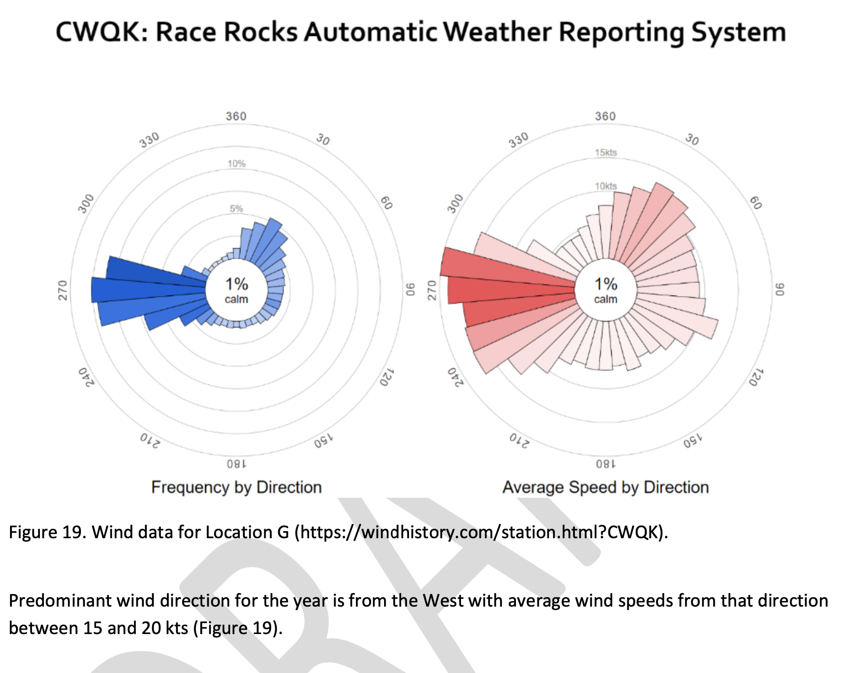
Page 25
Strait of Juan de Fuca (south of Race Rocks) (Location G);
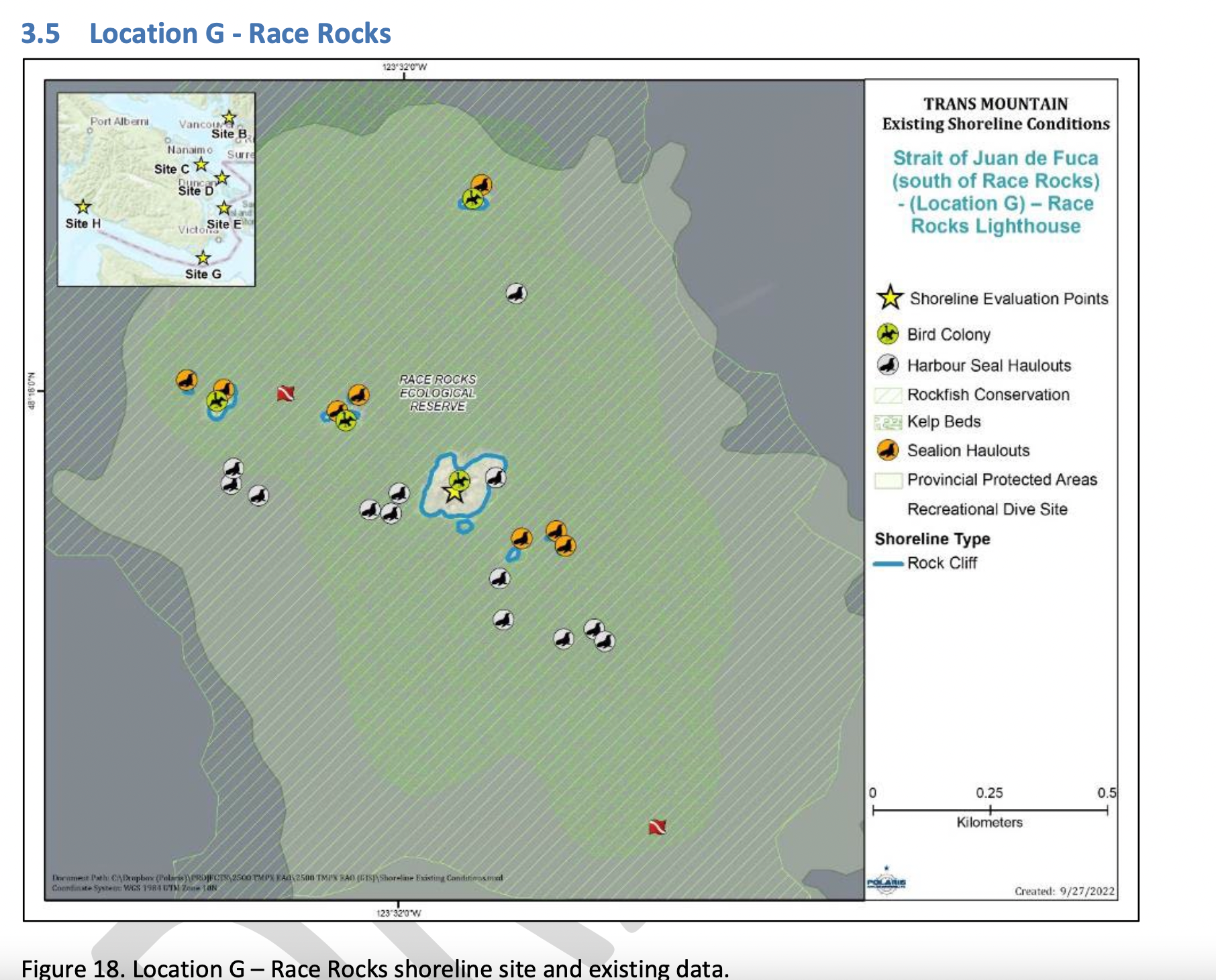
Figure 18 shows the Location G – Race Rocks site with the available existing spatial data. Shoreline data are from the Shorezone mapping effort available from the BC Data Catalogue, which show the shore type consisting of rock cliff. Shore-zone Bioband data indicate the presence of barnacles, dark brown kelps, fucus, bull kelp, red algae, surf grass, and Verrucaria. Other data sources indicate offshore kelp beds and multiple seal and sealion haulouts. The Race Rocks Ecological Reserve (RRER) website (https://racerocks.ca/home/) provides more details on ecological resources documented and studied at the site, but not in a spatial format for mapping.

COMMENTS :  The exceptionally high Biodiversity of the area and high level of protection since 1980 as a Provincial Ecological Reserve  are not reflected at all in the map presented. If one were to look at the Race Rocks Taxonomy presented at https://racerocks.ca/race-rocks-animals-plants/taxonomy-image-gallery/ there may be a better appreciation of the natural capital of this area

  1. Rock Cliff  Beach designation is inaccurate.. there is a pebble beach and Intertidal areas with tidepools on much of the shorelines of the 9 islandfsd in the Archipelago.  Also several surge channels are located around the main island. 
  2. Bird Colonies :
    –no mentions is made of four species of nesting seabirds.
    –no mention is made of the fact this is a winter roosting area for thousands of seabirds.
    — no mention of the fact that the archipelago of islands are an important migratory stopover for marine and terrestrial migratory birds.
  3. Marine Mammals:
    –no mention is made of the fact this is the most northerly haul-out and pupping colony  for Elephant seals — no mention of the fact that California and Northern sealions haul  out in numbers over 1000 in the fall of the year. 
    —no mention  that the haul-out locations for harbour seals are also pupping colonies. 
    — no mention of the ocurrence of river otters and sea otters on and within the islands.
    – no mention of the fact that it is an important feeding area for Biggs killer whales. https://racerocks.ca/humpback-and-orca-sightings-race-rocks/
    –no mention of the fact that the surrounding waters have had a rapid increase in the past few years of Humpback whales 
  4. Invertebrates: 
    –The extremely high biodiversity of invertebrate species both inter-tidally and sub-tidally is not mentioned. 
    –Several rare species of invertebrates are found here and are not acknowledged
  5. Fish :
    –This is a rockfish protection area and all species of BC Rockfish are represented.– a high diversity of other fish are also represented here,  with even sitings of Sturgeon occurring.
  6. Marine Algae :
    –There is a much higher  species diversity of Marine Algae found in the ecological reserve than is n surrounding areas. 
    — the indication of kelp beds on the map presented here is totally inaccurate and insufficient.  Given the decline of kelp beds in our coastal water , this is highly relevant. 
  7. Indigenous and Historical Significance: 
    — the presence of archaeological sites and the significance of the historic structures cannot be minimized . All are sprayed with seawater and therefore subject to immersion in pollutants during intense winds  which occur regularly. 

===============================================================

Page 26


Comments:
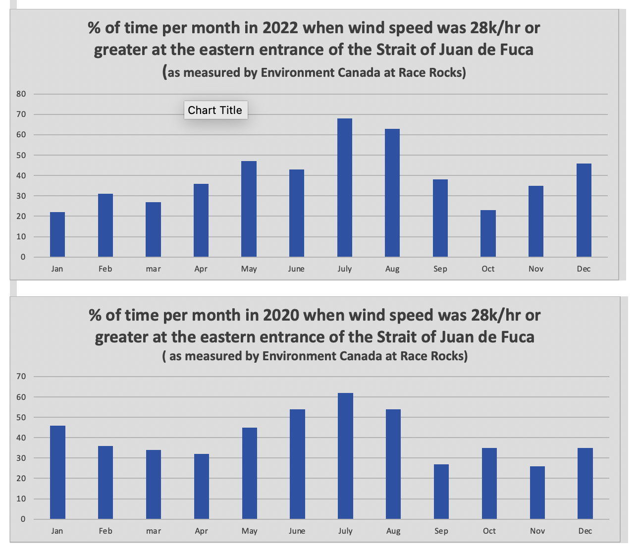
The reference at the Race Rocks website  from racerocks.ca which analyzes the Wind speed from observations of the hourly data provided by Environment Canada show a completely different picture . https://racerocks.ca/race-rocks-lightstation-weather-conditions-environment-canada-problems-for-oil-spill-cleanup/

 Some facts from the Environment Canada data:
1. In July of 2022  there were 11 days when the wind speed every hour was 28 km/hr or greater. and 69.5% of the hours in the month, clean up equipment could not be deployed due to high velocity wind conditions.
2. In March of 2023, the wind speed was 28 km/hr or greater  37% of the time.
3. In Februarry of 2023 , the wind speed was 28 km/hr or greater 43 % of the time
4. In January of 2023 , the wind speed was 28 km/hr or greater 36% of the time 

============================================================

Page 27


================================================

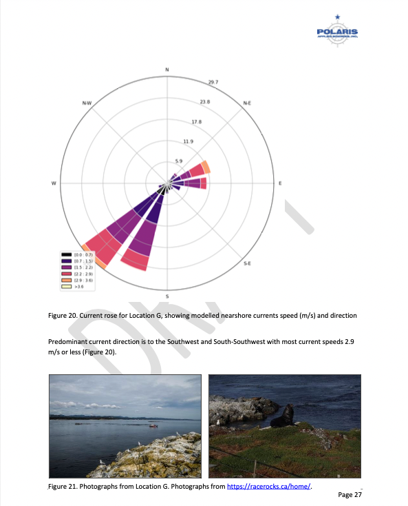
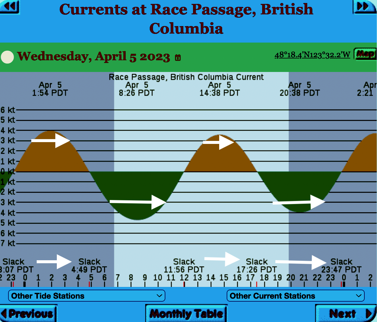
The reality of current speed  is that there is a very small window of time during the day that the waters around Race Rocks are not over three knots. In the graph below only in the few hours a day not covered by the white arrows could any boom placement be established. WHen looked at from this perspective, added onto the small windows of time when the wind speed is under 28 km per hour could spilled oil containment even be possible. 


=============================================================

From page 28 of the Polaris report

Field surveys were not conducted at Race Rocks due to the long lead time in acquiring a “research” permit from BC Parks to access the Ecological Reserve. Information detailed below comes from reviewing the existing data available, Google Earth, the RRER website, and a First Nations representative.
The shoreline at Race Rocks, specifically Great Race Rock, appears to be mostly bedrock cliff, ramp, and platform, possibly with some small pocket pebble/cobble beaches. Bedrock cliffs and ramps are observable in Figure 21 which show some example photographs from the Race Rocks Ecological Reserve website. The backshore appears to be mostly bedrock with some vegetation.
An active lighthouse along with several other buildings are present. Pearson College UWC conducts research and teaches classes at the site. Whale and sightseeing boats frequent the waters around Great Race Rock and are visible from photographs on the Race Rocks website and on Google Earth.
As mentioned before, Race Rocks is a BC Parks Ecological Reserve which are “areas selected to preserve representative and special natural ecosystems, plant and animal species, features and phenomena. Scientific research and educational purposes are the principal uses of ecological reserves”7. A wide variety of ecological resources are documented, tracked, and studied at the site. This documentation includes a weekly animal census, annual bird counts, and an entire list of species ever documented with photos/videos since 2000 (https://racerocks.ca/race-rocks-animals-plants/taxonomy-image-gallery/). Additional research conducted at the site can also be found on the RRER website. The extensive use of the site as a haulout location by pinnipeds is documented on the website and visible on Google Earth.
This area has historically been used by First Nations for harvesting food, as documented on the Race Rocks website, and a First Nations representative indicated that fishing is common in the waters around the site. Burial mounds/cairns have been researched and documented on Great Race Rock.
A helicopter pad is located near the lighthouse.
Based on the available data, and without visiting Race Rocks, the Shorezone mapping appears to be relatively accurate. The detailed observation of the flora and fauna on the Race Rocks website and other research conducted by Pearson College provides the most thorough documentation of the ecological resources present compared to any of the other sites visited.
7 https://bcparks.ca/eco_reserve/

================================================================

So much of what we are expected to do in response to the Trans Mountain EAO requests has been done before. 
However…. 
I am pointing out some information from work that Mike Fenger and myself did on the Board of Friends of Ecological Reserves the past for the NEB hearings . 
1. In this document, although it  lists species of several of the marine ecological reserves,  Race Rocks is included with examples 
page 48 -page 54 : Marine mammals
see page 52  
page 55-page 61 Birds 
page 63-67  fish (including forage fish on our beaches
page 67- page 71 .. Invertebrates
page 72- page  74  .. macroalgae
page 75-  terrestrial plants in upper foreshore areas
From this link ….
there is a lot of information of the biological resources along the Strait of Juan De Fuca also in section
3.5 SARA-Listed Species in Two Ecological Reserves and in appendix page 139
============================================
Garry Fletcher.. Metchosin Environmental Advisory Select Committee 

Herring Spawn Video from Denman Island

Why are BC residents so concerned about what might happen to their coastline from an increase in shipping and oil tankers?

We don’t have a scene like this video portrays in Metchosin, although we do get frenzy feeding by birds and mammals in the fall at Race Rocks but we do have forage fish which live on our beaches and provide year round food for the ecosystem.

Don’t miss this video from Denman Island : https://vimeo.com/121960894?fb_action_ids=10153160722717497&fb_action_types=

Information Requests from the Board of Friends of Ecological Reserves submitted to Kinder Morgan on Jan 15

On January 15, 2014, The Board of Friends of Ecological reserves submitted the round 2 set of Information Requests to Kinder Morgan /TMX project . Since it has some questions related to local sensitive marine ecological areas, It is posted here:

C33-4-1_-_Information_Request_No._2_-_A4G5Q9

Other posts on our concerns about the risk of oil spills on Metchosin’s Coastline may be found here:

50 other intervenors in the NEB hearings also submitted questions.. The link to these will be added here when the National Energy Board puts up a link.


Elephant Seal-dead on Weir’s beach

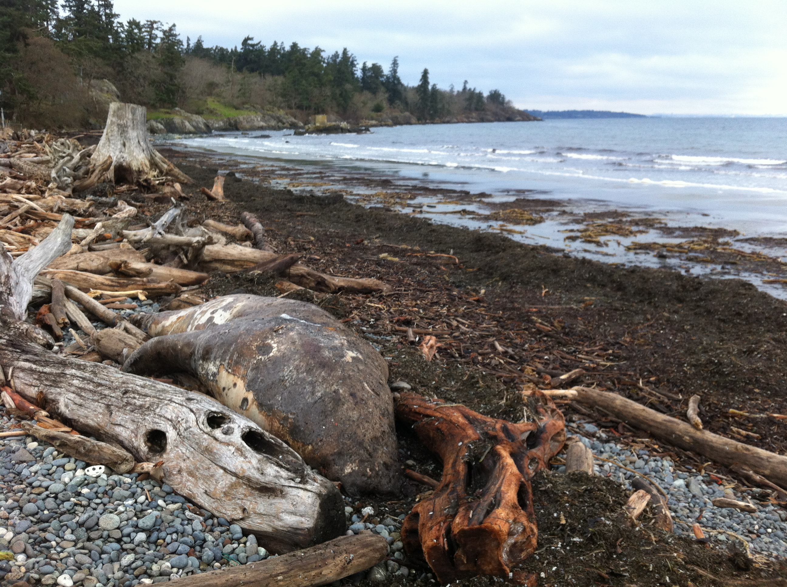
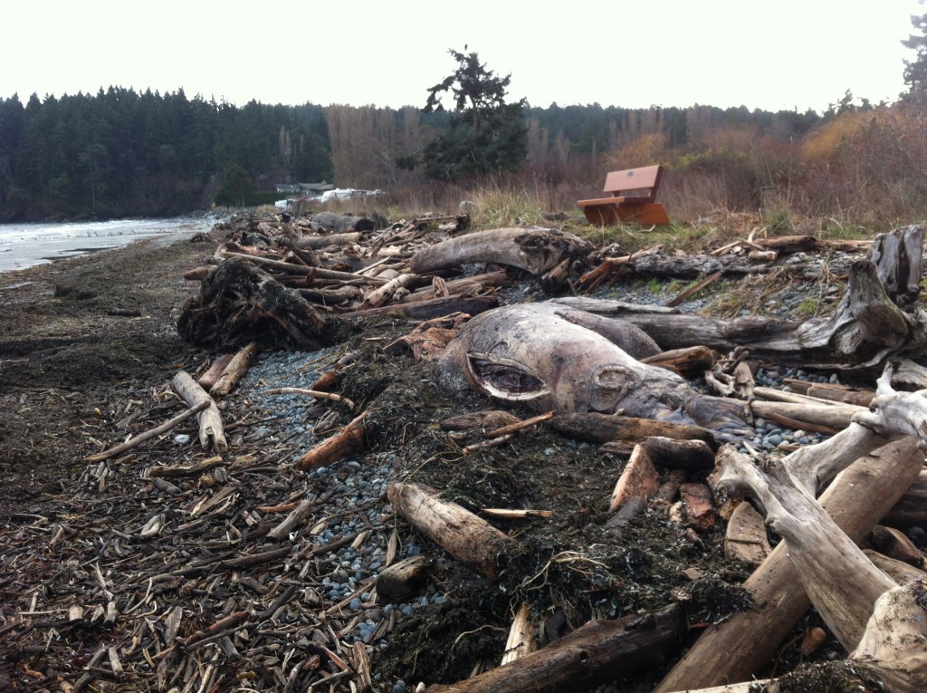
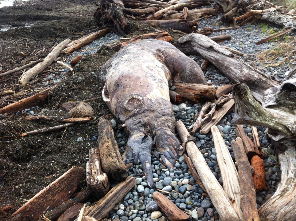
Metchosin resident Jan Poulin reported a dead marine mammal today on Weir’s beach. Below are some pictures. It looks like a mature male, up to 4 m in length. It had been washed up in the swell form the North East storms over the last week. It has been dead for some time and will eventually probably cause a problem for the residents of the area. It has been reported to DFO.

2014-12-26 gfweirselsealdead

male elephant seal, dead on Weir’s Beach photo: G. Fletcher

Other images of the elephant seal : December 26, 2014


River Otter: Lontra canadensis on the Metchosin Coastline

raisanov410ottereat copy

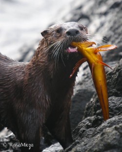
When she was an ecoguardian at Race Rocks in 2010, Raisa Mirza took this excellent photo of a river otter, just out of the water, eating a female kelp greenling .

River otters are fairly common along our shores.  Thus an entry for our species posts. In four stretches of shoreline in particular, we can expect to find them, where they have dens and produce offspring yearly.

1.  At Race Rocks
2. In Pedder Bay
3  At the entrance to Gooch Creek
4.  Along the Taylor Beach blufffs.


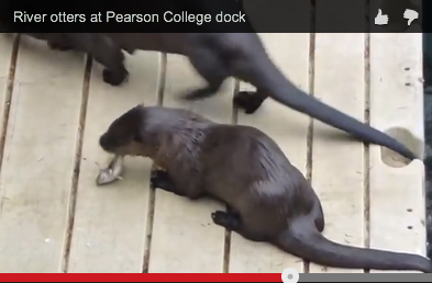
The Pearson College Marine Science reference has several references and images available on river otters.   riverotters atpc
Domain:  Eukarya
Kingdom:  Animalia
Phylum:  Chordata
Class:  Mammalia
Order:  Carnivora
Family:  Mustelidae
Subfamily:  Lutrinae
Genus:  Lontra
Species:  canadensis pacifica (Schreber, 1977)
Common Name: River Otter

One should be cautioned when walking dogs on Taylor Beach to restrain them if otters are in the area. Otters have been known to attack even large dogs that have pursued them into the ocean.

Ship Noise and its Effect on Killer Whales

In April, 2014 I attended the Salish Sea Ecosystem Conference in Seattle. One of the presentations  which surprized me showed  the risk to the Southern resident Killer Whale populations from Noise Imapcts in the Salish Sra under Commercial shipping growth Scenarios. Following is a reference to Beam Reach which carries a summary presentation of this. — Scott Veirs, Beam Reach Marine Science & Sustainability; Val Veirs, Colorado College; Jason Wood, Sea Mammal Research Unit

soundimpacticonEmazing talk on fossil fuel ship noise & killer whales

This afternoon I’m giving a talk at the 2014 Salish Sea Ecosystem Conference in which I present our estimates of sound pressure levels from commercial ships in Haro Strait, the core of the summertime critical habitat for the Southern Resident killer whales. I also take a first look at noise impacts of the current tanker and bulk carrier fleets and ask how those impacts may change if a suite of proposed fossil fuel export facilities are added to the Salish Sea.

– See more at: http://www.beamreach.org/2014/04/30/emaze-talk-fossil-fuel-ship-noise-killer-whales

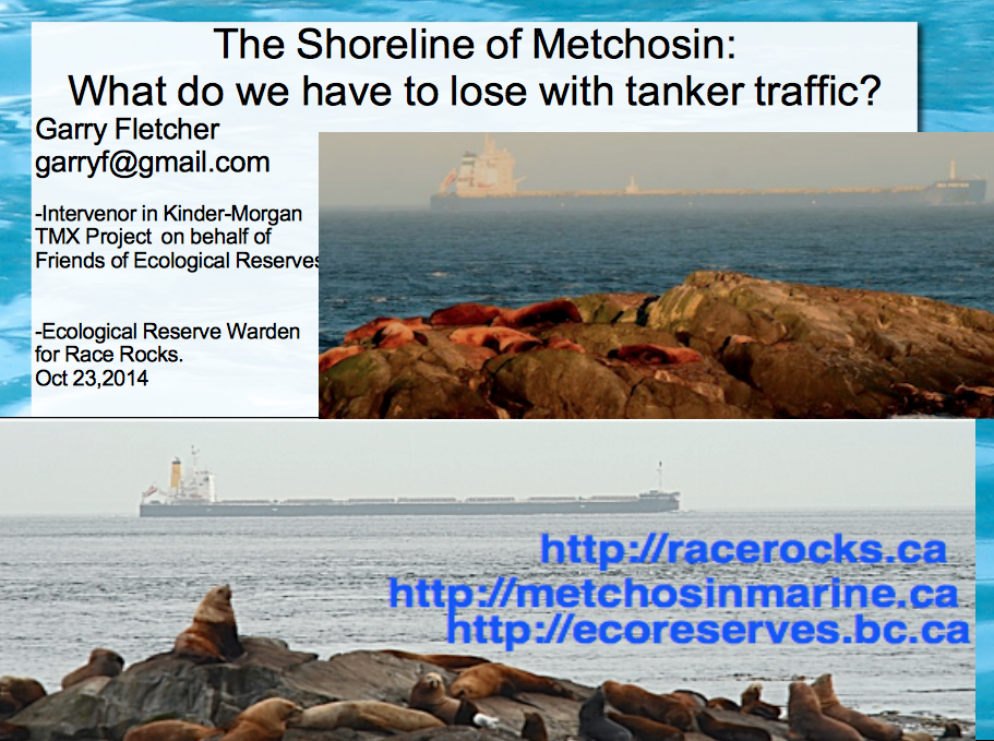
The Shoreline of Metchosin: What do we have to lose with tanker traffic

Along the shoreline of Metchosin and underwater we have ecosystems which are at risk of being heavily impacted in the event of an impending oil spill catastrophe given all the proposed projects which will increase ship traffic to unacceptable levels in the Strait of Juan de Fuca. The presentation by Garry Fletcher linked here was done on the evening of October 23rd, 2014 at the Metchosin Community Hall organized by Karyn Woodland and the local Dogwood Initiative Group. ( NOTE: comments are included under the images and all images are copyright of the photographers who took them, John Harper(GeoBC); the ecoguardians at Race Rocks: Ryan Murphy, Raisa Mirza, Alex Fletcher, Anne Stewart, Adam Harding, Mike Robinson and Courtenay Edwards, and myself. The graphics from the first part on Oil Spill Risk are from  posts of Nov.4 on Oil Spill Risks
Link to a description of the three presentations to the Town hall meeting by Kai Nagata of the Dogwood Initiative, Andrew Weaver, Green Party MLA for Oak Bay and Intervenor in the Kinder Morgan hearings, and Garry Fletcher, Intervenor for the Board of Friends of Ecological Reserves in the Kinder-Morgan / Trans Mountain Expansion project hearings. gfpresent

The Future for our Elephant Seal Population in the Event of Oil Spills.


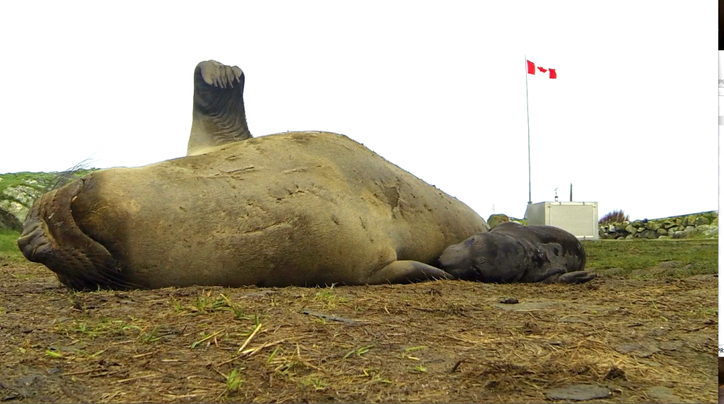
Elephant seal mother and pup born at Race Rocks Ecological reserve on January 14, 2014

Elephant seal mother and pup born at Race Rocks Ecological Reserve on January 14, 2014,  Photo by Alex Fletcher

This post has been adapted from a January 24 entry on the racerocks.ca website

British Columbians and Metchosinites in particular can take great satisfaction in the fact that an Elephant seal colony is being slowly established in British Columbia right on their doorstep, We can can still go to camera 1 on racerocks.ca to see an elephant seal pup being nursed via a webcam on an island beside Metchosin.  The reality is that the risks these animals face in the Strait of Juan de Fuca if they are to maintain a population increase are now becoming even more challenging.

Currently about 6,000 large commercial vessels transit Canadian and U.S. waters toward Vancouver or Washington ports each year. Each month about five large oil tankers ply the waters down the international border within a few kilometres of the Race Rocks Ecological Reserve.

Under the Kinder Morgan Pipeline Proposal, up to 34 tankers a month would be loaded with oil at a terminal outside Vancouver, then travel through Haro Strait and the Strait of Juan de Fuca for export to markets in Asia and the U.S.  These are tankers in excess of 200 metres in length. 

The $5.4 billion expansion project would nearly triple pipeline capacity from about 300,000 to 890,000 barrels of crude oil a day to meet customer demand. Much of that future cargo will likely be diluted bitumen from Canada’s tar  sands. If approved, the expansion is expected to be operational in late 2017. The pipeline is operated by Kinder Morgan Canada and owned by Houston-based Kinder Morgan Energy Partners LP.

The potential of collision and oil spills is unparalleled, and you can’t clean oil off a two ton marine mammal very easily let alone the volumes of marine life it consumes daily for survival. It would be a miracle indeed if we still have elephant seals at Race Rocks in 2020, the 40th anniversary of the Ecological Reserve. 

G.Fletcher

References we could all consider seriously:

  • Financial Liability for Kinder Morgan – Georgia Strait Alliance,

    “Residents of the Salish Sea region—Vancouver, Victoria, the Gulf Islands and Washington State—could see a four-fold increase in the number of oil tankers traveling from the Port of Metro Vancouver through Juan de Fuca Strait, if Kinder Morgan is permitted to build a new pipeline to carry oil from the tar sands to markets in Asia. Such a dramatic increase signals exponentially higher risk of oil spills and raises many questions about what is at risk, how the oil is “cleaned up”, and who pays for oil spill response. “

  • The Deepwater Horizon Oil Spill and Marine Mammals by the marine mammal Commission, an independent commission of the US government
  • Effects of Oil Spills on Marine and Coastal Wildlife–“Oil spills can impact wildlife directly through three primary pathways: —ingestion – when animals swallow oil particles directly or consume prey items that have been exposed to oil .—–absorption – when animals come into direct contact with oil inhalation – when animals breathe volatile organics released from oil or from “dispersants” applied by response teams in an effort to increase the rate of degradation of the oil in seawater. ——inhalation – when animals breathe volatile organics released from oil or from “dispersants” applied by response teams in an effort to increase the rate of degradation of the oil in seawater”
  • Effects of Oil Pollution on Marine WIldlife ”  Seals are very vulnerable to oil pollution because they spend much of their time on or near the surface of the water. They need to surface to breathe, and regularly haul out onto beaches. During the course of an oil pollution incident, they are at risk both when surfacing and when hauling out.”
  • Marine mammals and the Exxon Valdez Auteur : LOUGHLIN Thomas R. “This recently published book is a unique longitudinal study of the demise of an ecosystem due to a single acute environmental perturbation.”

Posts on this and other  local websites about the effects of Oilspills.