EXISTING SHORELINE CONDITIONS STUDY EAO Condition 39

The full pdf of this report is contained in this pdf:
BC EAO Condition 39 Exisitng Shoreline Conditions Report – May 2023 – for engagement

The purpose of this posting is to reference the part of the report referring to Metchosin’s coastline  and to provide comment on it.

===========================================================

From page 4 of the REPORT:
1 Introduction
As defined by the amendment to Trans Mountain’s BC Environmental Assessment Certificate (EAC) issued by the Province of British Columbia (the Province) on February 24, 2022, Trans Mountain must prepare an Existing Shorelines Condition Report and submit to the Province within 18 months (August 2023) as Condition No. 39.

Polaris Applied Sciences was retained to prepare a report containing shoreline baseline data for shoreline areas closest to spill scenario locations modeled along the marine shipping route and submitted in the Project application. The Province listed the specific scenario locations for the purpose of this study (Figure 1) as:

  • English Bay (Location B)
  • Roberts Bank (Location C)
  • Strait of Georgia (Location D)
  • Arachne Reef (Location E)
  • Strait of Juan de Fuca (south of Race Rocks) (Location G); and
  • Buoy J (Location H)


Page 25
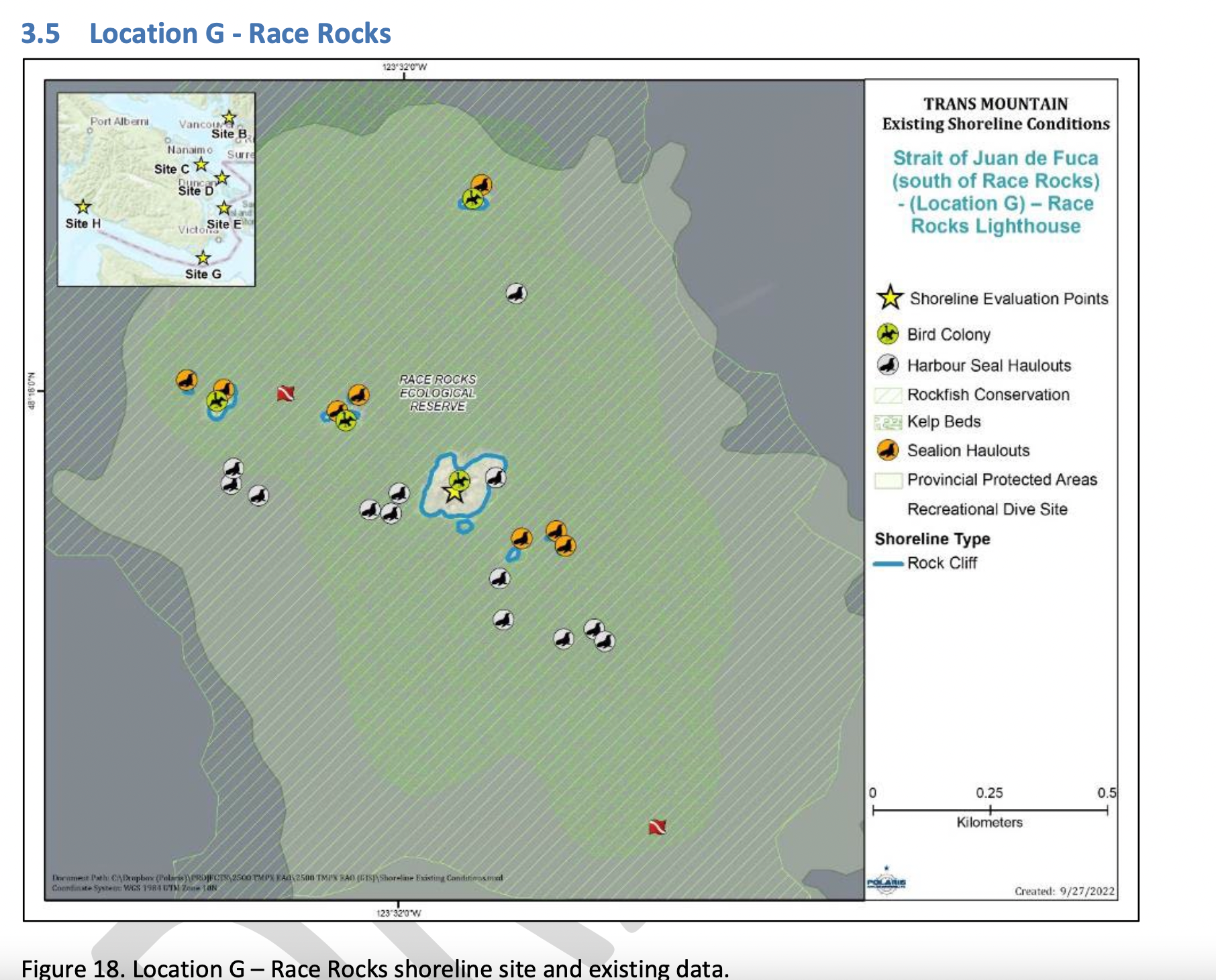
Strait of Juan de Fuca (south of Race Rocks) (Location G);
Figure 18 shows the Location G – Race Rocks site with the available existing spatial data. Shoreline data are from the Shorezone mapping effort available from the BC Data Catalogue, which show the shore type consisting of rock cliff. Shore-zone Bioband data indicate the presence of barnacles, dark brown kelps, fucus, bull kelp, red algae, surf grass, and Verrucaria. Other data sources indicate offshore kelp beds and multiple seal and sealion haulouts. The Race Rocks Ecological Reserve (RRER) website (https://racerocks.ca/home/) provides more details on ecological resources documented and studied at the site, but not in a spatial format for mapping.

COMMENTS :  The exceptionally high Biodiversity of the area and high level of protection since 1980 as a Provincial Ecological Reserve  are not reflected at all in the map presented. If one were to look at the Race Rocks Taxonomy presented at https://racerocks.ca/race-rocks-animals-plants/taxonomy-image-gallery/ there may be a better appreciation of the natural capital of this area

  1. Rock Cliff  Beach designation is inaccurate.. there is a pebble beach and Intertidal areas with tidepools on much of the shorelines of the 9 islandfsd in the Archipelago.  Also several surge channels are located around the main island. 
  2. Bird Colonies :
    –no mentions is made of four species of nesting seabirds.
    –no mention is made of the fact this is a winter roosting area for thousands of seabirds.
    — no mention of the fact that the archipelago of islands are an important migratory stopover for marine and terrestrial migratory birds.
  3. Marine Mammals:
    –no mention is made of the fact this is the most northerly haul-out and pupping colony  for Elephant seals — no mention of the fact that California and Northern sealions haul  out in numbers over 1000 in the fall of the year. 
    —no mention  that the haul-out locations for harbour seals are also pupping colonies. 
    — no mention of the ocurrence of river otters and sea otters on and within the islands.
    – no mention of the fact that it is an important feeding area for Biggs killer whales. https://racerocks.ca/humpback-and-orca-sightings-race-rocks/
    –no mention of the fact that the surrounding waters have had a rapid increase in the past few years of Humpback whales 
  4. Invertebrates: 
    –The extremely high biodiversity of invertebrate species both inter-tidally and sub-tidally is not mentioned. 
    –Several rare species of invertebrates are found here and are not acknowledged
  5. Fish :
    –This is a rockfish protection area and all species of BC Rockfish are represented.– a high diversity of other fish are also represented here,  with even sitings of Sturgeon occurring.
  6. Marine Algae :
    –There is a much higher  species diversity of Marine Algae found in the ecological reserve than is n surrounding areas. 
    — the indication of kelp beds on the map presented here is totally inaccurate and insufficient.  Given the decline of kelp beds in our coastal water , this is highly relevant. 
  7. Indigenous and Historical Significance: 
    — the presence of archaeological sites and the significance of the historic structures cannot be minimized . All are sprayed with seawater and therefore subject to immersion in pollutants during intense winds  which occur regularly. 

===============================================================

Page 26


Comments:
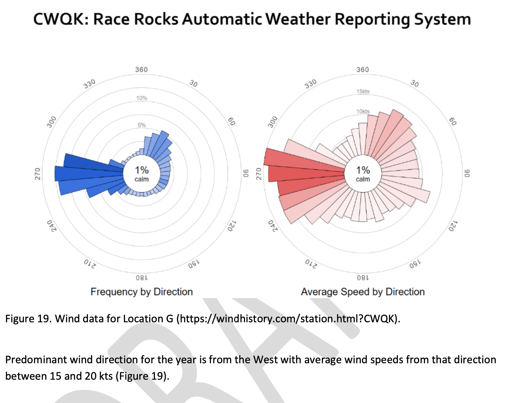
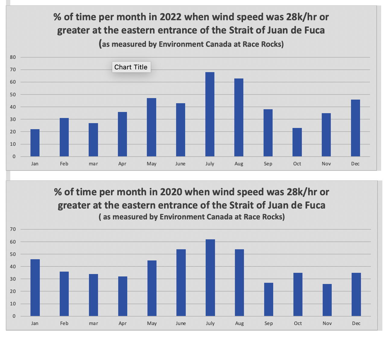
The reference at the Race Rocks website  from racerocks.ca which analyzes the Wind speed from observations of the hourly data provided by Environment Canada show a completely different picture . https://racerocks.ca/race-rocks-lightstation-weather-conditions-environment-canada-problems-for-oil-spill-cleanup/

 Some facts from the Environment Canada data:
1. In July of 2022  there were 11 days when the wind speed every hour was 28 km/hr or greater. and 69.5% of the hours in the month, clean up equipment could not be deployed due to high velocity wind conditions.
2. In March of 2023, the wind speed was 28 km/hr or greater  37% of the time.
3. In Februarry of 2023 , the wind speed was 28 km/hr or greater 43 % of the time
4. In January of 2023 , the wind speed was 28 km/hr or greater 36% of the time 

============================================================

Page 27


================================================

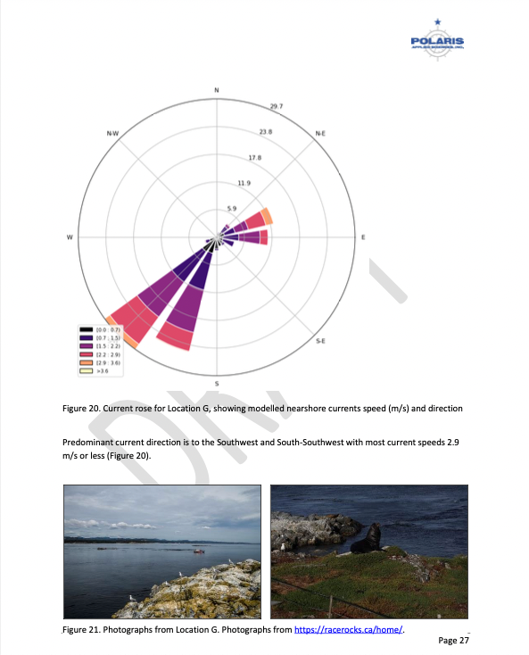
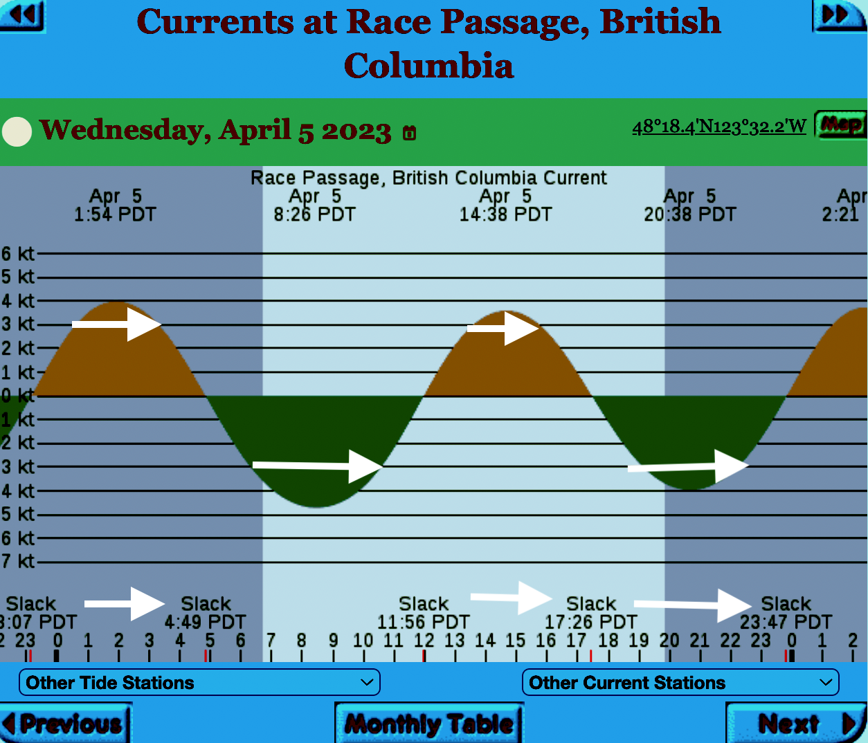
The reality of current speed  is that there is a very small window of time during the day that the waters around Race Rocks are not over three knots. In the graph below only in the few hours a day not covered by the white arrows could any boom placement be established. WHen looked at from this perspective, added onto the small windows of time when the wind speed is under 28 km per hour could spilled oil containment even be possible. 


=============================================================

From page 28 of the Polaris report

Field surveys were not conducted at Race Rocks due to the long lead time in acquiring a “research” permit from BC Parks to access the Ecological Reserve. Information detailed below comes from reviewing the existing data available, Google Earth, the RRER website, and a First Nations representative.
The shoreline at Race Rocks, specifically Great Race Rock, appears to be mostly bedrock cliff, ramp, and platform, possibly with some small pocket pebble/cobble beaches. Bedrock cliffs and ramps are observable in Figure 21 which show some example photographs from the Race Rocks Ecological Reserve website. The backshore appears to be mostly bedrock with some vegetation.
An active lighthouse along with several other buildings are present. Pearson College UWC conducts research and teaches classes at the site. Whale and sightseeing boats frequent the waters around Great Race Rock and are visible from photographs on the Race Rocks website and on Google Earth.
As mentioned before, Race Rocks is a BC Parks Ecological Reserve which are “areas selected to preserve representative and special natural ecosystems, plant and animal species, features and phenomena. Scientific research and educational purposes are the principal uses of ecological reserves”7. A wide variety of ecological resources are documented, tracked, and studied at the site. This documentation includes a weekly animal census, annual bird counts, and an entire list of species ever documented with photos/videos since 2000 (https://racerocks.ca/race-rocks-animals-plants/taxonomy-image-gallery/). Additional research conducted at the site can also be found on the RRER website. The extensive use of the site as a haulout location by pinnipeds is documented on the website and visible on Google Earth.
This area has historically been used by First Nations for harvesting food, as documented on the Race Rocks website, and a First Nations representative indicated that fishing is common in the waters around the site. Burial mounds/cairns have been researched and documented on Great Race Rock.
A helicopter pad is located near the lighthouse.
Based on the available data, and without visiting Race Rocks, the Shorezone mapping appears to be relatively accurate. The detailed observation of the flora and fauna on the Race Rocks website and other research conducted by Pearson College provides the most thorough documentation of the ecological resources present compared to any of the other sites visited.
7 https://bcparks.ca/eco_reserve/

================================================================

So much of what we are expected to do in response to the Trans Mountain EAO requests has been done before. 
However…. 
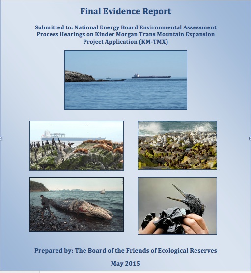
I am pointing out some information from work that Mike Fenger and myself did on the Board of Friends of Ecological Reserves the past for the NEB hearings . 
1. In this document, although it  lists species of several of the marine ecological reserves,  Race Rocks is included with examples 
page 48 -page 54 : Marine mammals
see page 52  
page 55-page 61 Birds 
page 63-67  fish (including forage fish on our beaches
page 67- page 71 .. Invertebrates
page 72- page  74  .. macroalgae
page 75-  terrestrial plants in upper foreshore areas
From this link ….
there is a lot of information of the biological resources along the Strait of Juan De Fuca also in section
3.5 SARA-Listed Species in Two Ecological Reserves and in appendix page 139
============================================
Garry Fletcher.. Metchosin Environmental Advisory Select Committee 

An Interesting representation of the Coastal Consequences of KM/TMX Pipeline

BurnabyKM:TMXThis presentation from the Globe and Mail provides an interesting  report n the future of Oil transportation on our coast.

“Weigh Anchor

With the BC Greens and NDP reaching an agreement to form government, the future of the Trans Mountain pipeline is up in the air. The expansion project could bring billions in new revenue, but it would also mean an increase in coast-to-port tanker traffic, and with that, an increased risk of oil spills. We follow a tanker as it threads the needle from Burnaby to the open ocean.”
Tanker

Herring Spawn Video from Denman Island

Why are BC residents so concerned about what might happen to their coastline from an increase in shipping and oil tankers?

We don’t have a scene like this video portrays in Metchosin, although we do get frenzy feeding by birds and mammals in the fall at Race Rocks but we do have forage fish which live on our beaches and provide year round food for the ecosystem.

Don’t miss this video from Denman Island : https://vimeo.com/121960894?fb_action_ids=10153160722717497&fb_action_types=

Winter foraging seabirds still off Taylor Beach

On my daily walks on Taylor Beach since the fall, I have noticed that there has been a constant presence of the diving ducks off shore which rely on the forage fish from Taylor Beach.  It will be interesting to see when they depart to go to their nesting grounds, usually to the North on Inland lakes.
Today a common loon, several red-breasted mergansers, buffleheads and surf scoters are still scattered over the waterfront.

No estimate is available on the number of diving birds that winter along the waterfront around the southern end of Vancouver Island depending on forage fish for survival but the sum total would probably be considerable given what we are regularly seeing in this area off Taylor Beach. In our efforts as intervenors on behalf of Friends of Ecological reserves, we have been aware and questioned the importance of the over-wintering population of seabirds in the area which would be severely affected in the event of a catastrophic oil spill.   Unfortunately the level of environmental impact assessment by the pipeline and oil transport company in this area which is a few miles from the intended vessel traffic lane does not exist.

In our recent Round 2  intormation requests , we tried to get KM/ Trans Mountain to acknowledge the importance of modelling a spill of their toxic diluted bitumin off Victoria. They have refused to do so so far .

SInce Taylor beach is a spawning beach for two forage fish, Pacific Smelt and sand lance  which provide food for these marine birds, one might reflect on the way we humans use and abuse the beach, the habitat of the forage fish. Numerous randomly placed beach fires  and  horse traffic which punches up the beach  are concerns which should be addressed in Metchosin .


Bitumen spill effects on waterways, oceans unknown, draft federal report says

See the link to CBC News:

Exerpts below:

“Critics say the federal government has been trying to hide legitimate concerns about the consequences of oilsands pipelines by keeping a report under wraps on the possible environmental threats posed.

—“If this report has been around since 2013 and not been released, then it makes me think they must be trying to hide something.”

—Francois Poirier, president of TransCanada’s Energy East pipeline project, downplayed such concerns.

–Toxicology research ‘lacking’

—“In particular, research on the toxicology of bitumen is lacking,” says the draft report, which was commissioned in response to concerns raised at the Northern Gateway pipeline hearings.

“—-An early draft of the report lays out 10 specific “knowledge gaps” about bitumen and various substances used to dilute it when it’s pumped through pipelines.”

—“Very little information is available on the physical and chemical characteristics of oilsands-related products following a spill into water,” it says. “Research on the biological effects of oilsands-related products on aquatic organisms is lacking.”

—“A better understanding of the fate and behaviour of these products is critical for assessing the potential risk to aquatic organisms.”

See the link to CBC News:

Information Requests from the Board of Friends of Ecological Reserves submitted to Kinder Morgan on Jan 15

On January 15, 2014, The Board of Friends of Ecological reserves submitted the round 2 set of Information Requests to Kinder Morgan /TMX project . Since it has some questions related to local sensitive marine ecological areas, It is posted here:

C33-4-1_-_Information_Request_No._2_-_A4G5Q9

Other posts on our concerns about the risk of oil spills on Metchosin’s Coastline may be found here:

50 other intervenors in the NEB hearings also submitted questions.. The link to these will be added here when the National Energy Board puts up a link.


Trans Mountain Analysis of Tanker /Tugs

Screen Shot 2015-01-02 at 11.02.39 AM

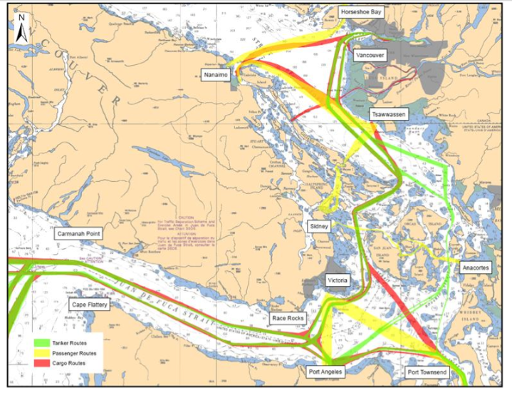
Trans mountain projection of Vessel traffic lanes in the Strait of Georgia and Strait of Juan de Fuca.

Recently, Trans Mountain released a Response to the National Energy Board  Information Request , TERMPOL Report and Outstanding Filings from the National Energy Board:

(Def: TRC= TERMPOL Review Committee )


Below are some notes on this document:


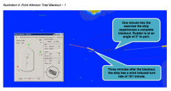
tanker-scenario

This scenario was modelled to show the results of no tug escort of tankers coming out from the Westridge Terminal in Burnaby

tanker scenario2

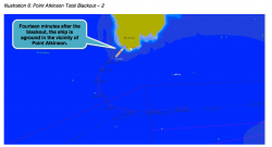
14 minutes after a Blackout of a tanker’s control systems, without s tug escort, it hits the Coast.

Page 4 of 26
Recommendation 8: Trans Mountain should develop a tug matrix identifying appropriate tug specifications for untethered tug escort of Project tankers for the Strait of Georgia in consultation with the Pacific Pilotage Authority, BC Coast Pilots, and Transport Canada.

As described in response to NEB IR No. 1.59a (A3W9H8), Trans Mountain will make it a requirement of acceptance for tankers nominated to load at Westridge to have a suitable arrangement for the proposed enhanced tug escort. Trans Mountain will develop a tug matrix for inclusion as part of its Tanker Acceptance Standard to prescribe minimum tug capabilities required upon departure of the tanker. The tug matrix will define the capabilities and number of tugs required for foreseeable meteorological and ocean conditions and based on tanker and cargo size. The tug matrix will be developed by a qualified third-party consultant, in conjunction with the tug operators and regulatory authorities.

Page 5 of 26 Recommendation 9: Trans Mountain should implement extended untethered escort for outbound laden Project tankers through the Juan de Fuca Strait. (3.2.4 Proposed Risk Mitigation Measures)

TM Remarks,Comments, Actions:
As described in response to NEB IR No. 1.59a (A3W9H8), Trans Mountain will make it a requirement of acceptance for tankers nominated to load at the Westridge Marine Terminal to have a suitable arrangement for the proposed enhanced tug escort during its outbound transit through the Juan de Fuca Strait in accordance with the tug matrix developed in Recommendation 8. Tankers that do not commit to tug escort in the Juan de Fuca Strait during their laden passage shall be denied their approval to load at the Westridge Marine Terminal.

Recommendation 10: Should Trans Mountain revise its tanker acceptance process to require untethered tug escort of Project tankers through the Juan de Fuca Strait, it should develop a tug matrix identifying appropriate tug specifications in consultation with the Pacific Pilotage Authority and Transport Canada.
Response:Agreed. Please see comments above regarding Recommendation 8
Page 10 of 26

Finding 18: The TRC supports extending the pilot disembarkation zone and tethered tug escort requirements for Project tankers to an area in the vicinity of Race Rocks, weather permitting and subject to the requirements identified in a Pacific Pilotage Authority ‘Notice to Industry’. (3.2.4 Proposed Risk Mitigation Measures)
Accepted.

Trans Mountain is pleased with the TRC’s support for extending the pilot disembarkation zone and tethered tug escort requirements for Project tankers to an area in the vicinity of Race Rocks, weather permitting and subject to the requirements identified in a future Pacific Pilotage Authority ‘Notice to Industry’.

Page 16 of 26
c) TERMPOL Submission

In its Application Trans Mountain had included information from the quantitative risk assessment carried out by DNV, which was also submitted to TERMPOL for the committee’s review. Volume 8C, TERMPOL 3.15 (General Risk Analysis and Intended Methods of Reducing Risks, Trans Mountain Expansion Project, A3S5F4, A3S5F6, A3S5F8).

While the TERMPOL submission had proposed a number of enhanced laden tanker risk reduction measures for consideration (TERMPOL 3.15, Chapter 7), only two in-transit measures were included in the detailed quantification of probabilities (TERMPOL 3.15, Chapter 10), these were: · Extending tug escort for the laden tanker to areas of the route that currently do not require such escort (TERMPOL 3.15, Chapter 7.3.1); · Implementing a laden tanker Moving Exclusion Zone (MEZ) (TERMPOL 3.15, Chapter 7.3.2). Comparison of oil spill probabilities utilized a comparison of three primary scenarios of traffic and enhanced risk reduction measures. These were:  Case 0: Forecast traffic in 2018 without TMEP (60 Trans Mountain tankers)

Case 1: Forecast traffic in 2018 with TMEP (408 Trans Mountain tankers)
Case 1b: Same as Case 1 but with expanded tug escort and moving exclusion zone for loaded Trans Mountain tankers.

TERMPOL Review Committee Report

The MEZ was intended as a means to further reduce collision probability through enhanced situational awareness of both the tanker and surrounding vessels. The TRC did not endorse the MEZ concept in the manner proposed in the TERMPOL submission because the TRC has determined that current regulations including ColRegs, Pilotage, and VTS are adequate and no further regulatory change was necessary to accommodate the Project.

In its report the TERMPOL Review Committee endorsed the following enhanced risk control recommendations for in-transit laden tankers:  Extended use of tethered and untethered tug escort; as shown in figures 1 and 2 below.

(Recommendations 8, 9, 10 and Finding 17); · Extension of the pilot disembarkation zone (Finding 18);


Page 17 of 26

Refinements from First Round IRs
In response to intervenor requests in the first round of IRs, further assessment of risk and risk controls was conducted resulting in the refinement of the values presented in the TERMPOL submission. Specifically these IR responses were:  Research by DNV into the area VTS (Evaluation of VTS Capabilities for TERMPOL 3.15,

Trans Mountain Pipeline ULC, 15 August 2014) determined that VTS capability was far more than what had been modeled. (A4A2Z7, A4A2Z8)

· Fast time simulation study of tanker drift in Juan de Fuca Strait (Maneuvering Assessment – Juan de Fuca Strait Proposed Tug Escort). (A4A7R1)
Strait of Georgia proposed tug escort simulation study (Lantec, 2014). This and the previous study were carried out and provided to the TRC upon their request.

· Detailed assessment of collision risk in Segment 2 (Burrard Inlet); see response to PMV IR No. 1.8.1 (A3X6V4).

· Upgraded the bollard pull of tugs used in the model (40 tonnes to 70 tonnes), which better reflects the tugs available in the region for escorting laden tankers as shown in Page 19 of 26:

Thus the fundamental conclusion submitted in the Application does not change; that is, that the existing marine network is well managed and safe and has the capacity to safely accommodate Project tankers with application of agreed risk mitigation measures and that oil cargo spill risk in the region will remain similar and comparable with current conditions.

Page 22 of 26

statement after the two pink maps:

References:
The Effect of Enhanced Situational Awareness on Collision Risk, Technical Note, November 2014 (DNV GL).
Strait of Georgia Proposed Tug Escort Simulation Study (Lantec, 2014)

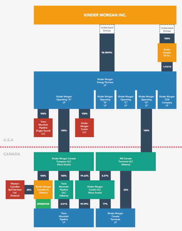
How Trans Mountain Project Will Pump Profits to Its Texas Owners Charting the Houston-driven inner workings of Kinder Morgan.

While doing work as an Intervenor for the Board of Friends of Ecological Reserves in the National Energy Board hearings on the Kinder Morgan Trans-Mountain Pipeline Expansion proposal , we have received notice throughout the past few months of the posting of many motions and questions to the Board from Intervenor Robyn Allan. The incredible amount of research she has done may be accessed on the NEB website:  https://docs.neb-one.gc.ca/ll-eng/llisapi.dll/Open/2451015

By Robyn Allan, Monday, January 10– TheTyee.ca

U.S.-based Kinder Morgan says its Trans Mountain expansion project represents financial and economic benefit to the Canadian economy, and our federal and provincial public treasuries.
Who would spend a year investigating such claims, rooted as they are in complex tax law, regulations and corporate structure? I did.
What I found made me conclude the opposite — Kinder Morgan drains financial wealth from our economy and does not pay its fair share of taxes.
I have written about the project’s complicated design to yield meagre tax revenues for Canadians in a previous Tyee article.
Now let me examine just how Canadian Kinder Morgan Canada Inc. is. The answer: hardly at all.
Pop the hood and take a look at Kinder Morgan’s inner workings and the idea that this is a Canadian company operating for the good of Canadians is dispelled quicker than Kinder Morgan can say injunction.
If you are bored by arcane discussions of corporate structure and governance, that may be just what Kinder Morgan is hoping. Please bear with me. It’s critical we know who really runs, and benefits from, Kinder Morgan Canada Inc.  —From the boys who brought us Enron

continued at: http://thetyee.ca/Opinion/2015/01/12/Trans-Mountain-Texas-Profits/

CHART.KMStructure_page_thumb

Click to enlarge (some browsers may require a second click to further enlarge image). Kinder Morgan corporate chart prepared by Robyn Allan. Graphic design by Karl Jensen.


Who pays for the real costs of the Oil Industry

We often hear that we need to extract oil and ship it overseas in order to support “Canadian jobs and the Economy”  I thought I would provide in this post a few links here to some references worth noting on the subsidization of the fossil fuel industry in Canada . GF

1. In July 2014, The Pembina Institute published a report titled: Fossil Fuel Subsidies: An analysis of federal financial support to Canada’s oil sector.
Published July 10, 2014 by Sarah Dobson, Amin Asadollahi

“The oil industry provides economic benefits in the short and medium term, but more permanent external benefits are less certain and are countered by the sector’s environmental impacts. This paper provides an analysis of federal financial support for the oil sector as well as recommendations on policy options. It recognizes progress made by Canada in phasing out certain subsidies, while noting that remaining federal direct and indirect support measures are largely inefficient and unnecessary.”

2. Fossil Fuels – At What Cost? Government Support for Upstream Oil Activities in Three Canadian Provinces: Alberta, Saskatchewan and Newfoundland & Labrador

Abstract:    Continue reading