EXISTING SHORELINE CONDITIONS STUDY EAO Condition 39

The full pdf of this report is contained in this pdf:
BC EAO Condition 39 Exisitng Shoreline Conditions Report – May 2023 – for engagement

The purpose of this posting is to reference the part of the report referring to Metchosin’s coastline  and to provide comment on it.

===========================================================

From page 4 of the REPORT:
1 Introduction
As defined by the amendment to Trans Mountain’s BC Environmental Assessment Certificate (EAC) issued by the Province of British Columbia (the Province) on February 24, 2022, Trans Mountain must prepare an Existing Shorelines Condition Report and submit to the Province within 18 months (August 2023) as Condition No. 39.

Polaris Applied Sciences was retained to prepare a report containing shoreline baseline data for shoreline areas closest to spill scenario locations modeled along the marine shipping route and submitted in the Project application. The Province listed the specific scenario locations for the purpose of this study (Figure 1) as:

  • English Bay (Location B)
  • Roberts Bank (Location C)
  • Strait of Georgia (Location D)
  • Arachne Reef (Location E)
  • Strait of Juan de Fuca (south of Race Rocks) (Location G); and
  • Buoy J (Location H)


Page 25
Strait of Juan de Fuca (south of Race Rocks) (Location G);
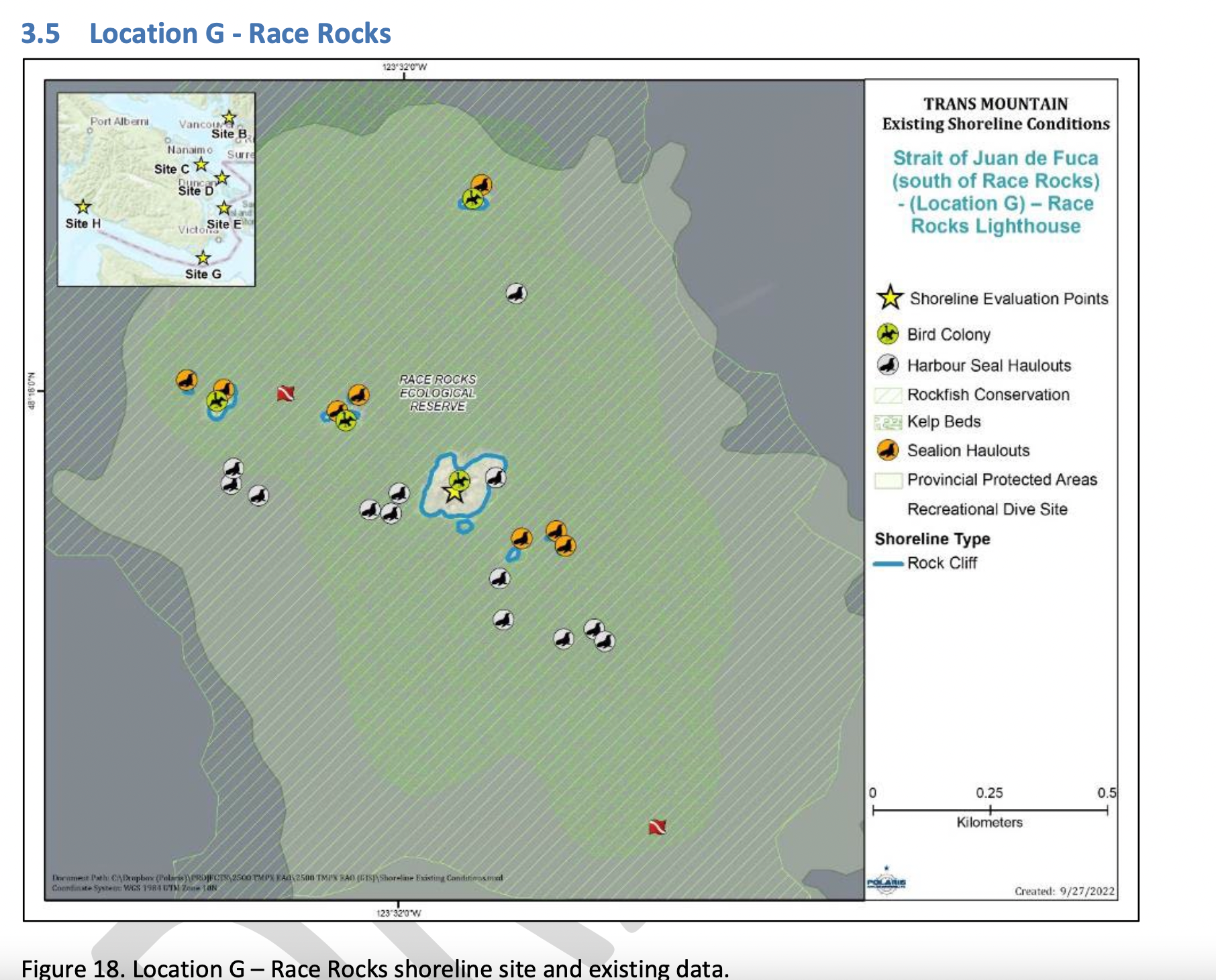
Figure 18 shows the Location G – Race Rocks site with the available existing spatial data. Shoreline data are from the Shorezone mapping effort available from the BC Data Catalogue, which show the shore type consisting of rock cliff. Shore-zone Bioband data indicate the presence of barnacles, dark brown kelps, fucus, bull kelp, red algae, surf grass, and Verrucaria. Other data sources indicate offshore kelp beds and multiple seal and sealion haulouts. The Race Rocks Ecological Reserve (RRER) website (https://racerocks.ca/home/) provides more details on ecological resources documented and studied at the site, but not in a spatial format for mapping.

COMMENTS :  The exceptionally high Biodiversity of the area and high level of protection since 1980 as a Provincial Ecological Reserve  are not reflected at all in the map presented. If one were to look at the Race Rocks Taxonomy presented at https://racerocks.ca/race-rocks-animals-plants/taxonomy-image-gallery/ there may be a better appreciation of the natural capital of this area

  1. Rock Cliff  Beach designation is inaccurate.. there is a pebble beach and Intertidal areas with tidepools on much of the shorelines of the 9 islandfsd in the Archipelago.  Also several surge channels are located around the main island. 
  2. Bird Colonies :
    –no mentions is made of four species of nesting seabirds.
    –no mention is made of the fact this is a winter roosting area for thousands of seabirds.
    — no mention of the fact that the archipelago of islands are an important migratory stopover for marine and terrestrial migratory birds.
  3. Marine Mammals:
    –no mention is made of the fact this is the most northerly haul-out and pupping colony  for Elephant seals — no mention of the fact that California and Northern sealions haul  out in numbers over 1000 in the fall of the year. 
    —no mention  that the haul-out locations for harbour seals are also pupping colonies. 
    — no mention of the ocurrence of river otters and sea otters on and within the islands.
    – no mention of the fact that it is an important feeding area for Biggs killer whales. https://racerocks.ca/humpback-and-orca-sightings-race-rocks/
    –no mention of the fact that the surrounding waters have had a rapid increase in the past few years of Humpback whales 
  4. Invertebrates: 
    –The extremely high biodiversity of invertebrate species both inter-tidally and sub-tidally is not mentioned. 
    –Several rare species of invertebrates are found here and are not acknowledged
  5. Fish :
    –This is a rockfish protection area and all species of BC Rockfish are represented.– a high diversity of other fish are also represented here,  with even sitings of Sturgeon occurring.
  6. Marine Algae :
    –There is a much higher  species diversity of Marine Algae found in the ecological reserve than is n surrounding areas. 
    — the indication of kelp beds on the map presented here is totally inaccurate and insufficient.  Given the decline of kelp beds in our coastal water , this is highly relevant. 
  7. Indigenous and Historical Significance: 
    — the presence of archaeological sites and the significance of the historic structures cannot be minimized . All are sprayed with seawater and therefore subject to immersion in pollutants during intense winds  which occur regularly. 

===============================================================

Page 26


Comments:
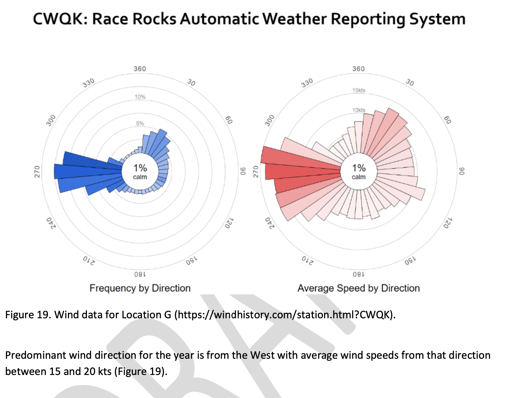
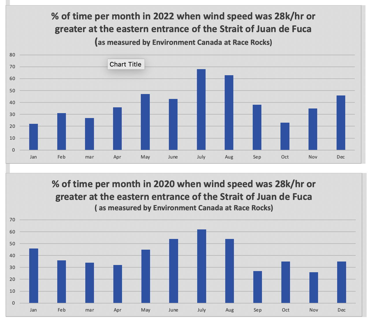
The reference at the Race Rocks website  from racerocks.ca which analyzes the Wind speed from observations of the hourly data provided by Environment Canada show a completely different picture . https://racerocks.ca/race-rocks-lightstation-weather-conditions-environment-canada-problems-for-oil-spill-cleanup/

 Some facts from the Environment Canada data:
1. In July of 2022  there were 11 days when the wind speed every hour was 28 km/hr or greater. and 69.5% of the hours in the month, clean up equipment could not be deployed due to high velocity wind conditions.
2. In March of 2023, the wind speed was 28 km/hr or greater  37% of the time.
3. In Februarry of 2023 , the wind speed was 28 km/hr or greater 43 % of the time
4. In January of 2023 , the wind speed was 28 km/hr or greater 36% of the time 

============================================================

Page 27


================================================

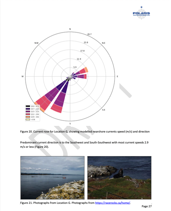
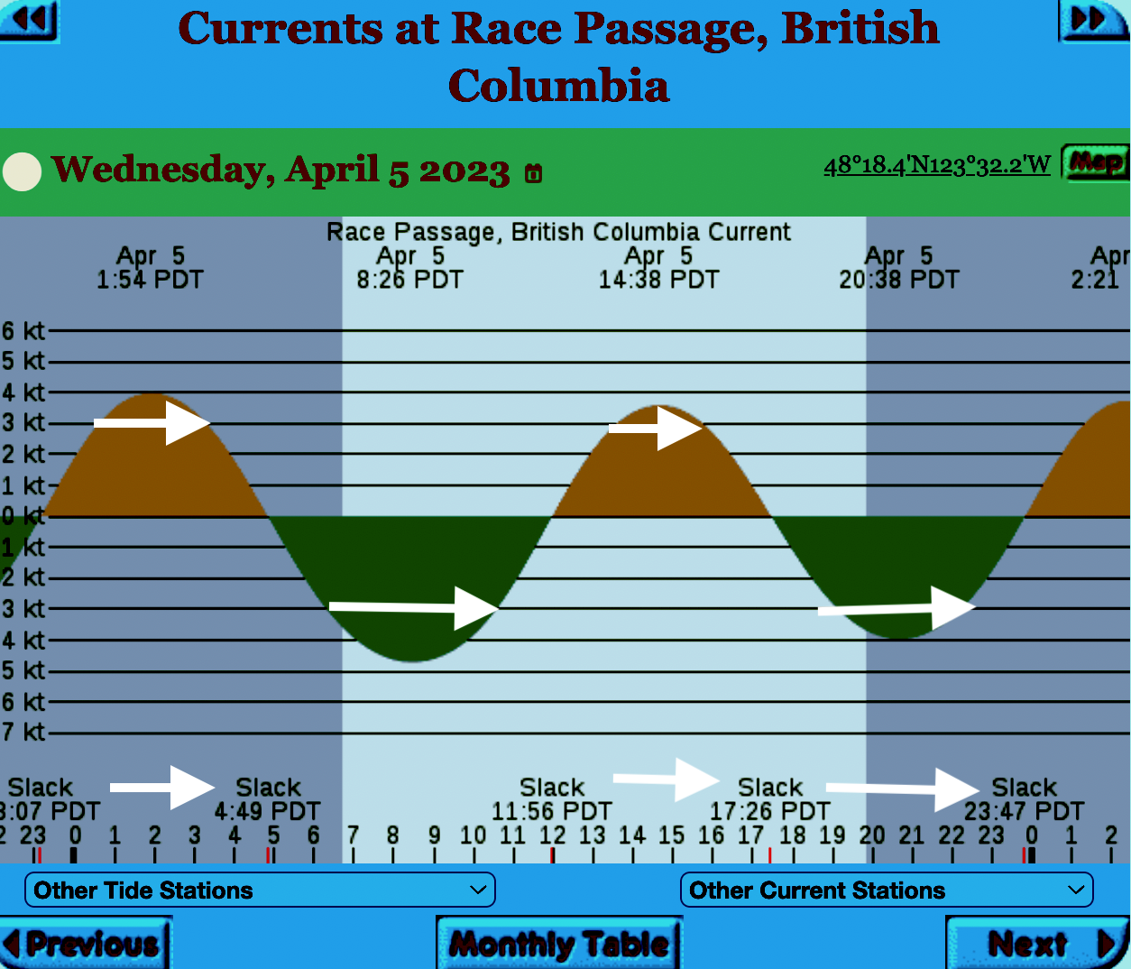
The reality of current speed  is that there is a very small window of time during the day that the waters around Race Rocks are not over three knots. In the graph below only in the few hours a day not covered by the white arrows could any boom placement be established. WHen looked at from this perspective, added onto the small windows of time when the wind speed is under 28 km per hour could spilled oil containment even be possible. 


=============================================================

From page 28 of the Polaris report

Field surveys were not conducted at Race Rocks due to the long lead time in acquiring a “research” permit from BC Parks to access the Ecological Reserve. Information detailed below comes from reviewing the existing data available, Google Earth, the RRER website, and a First Nations representative.
The shoreline at Race Rocks, specifically Great Race Rock, appears to be mostly bedrock cliff, ramp, and platform, possibly with some small pocket pebble/cobble beaches. Bedrock cliffs and ramps are observable in Figure 21 which show some example photographs from the Race Rocks Ecological Reserve website. The backshore appears to be mostly bedrock with some vegetation.
An active lighthouse along with several other buildings are present. Pearson College UWC conducts research and teaches classes at the site. Whale and sightseeing boats frequent the waters around Great Race Rock and are visible from photographs on the Race Rocks website and on Google Earth.
As mentioned before, Race Rocks is a BC Parks Ecological Reserve which are “areas selected to preserve representative and special natural ecosystems, plant and animal species, features and phenomena. Scientific research and educational purposes are the principal uses of ecological reserves”7. A wide variety of ecological resources are documented, tracked, and studied at the site. This documentation includes a weekly animal census, annual bird counts, and an entire list of species ever documented with photos/videos since 2000 (https://racerocks.ca/race-rocks-animals-plants/taxonomy-image-gallery/). Additional research conducted at the site can also be found on the RRER website. The extensive use of the site as a haulout location by pinnipeds is documented on the website and visible on Google Earth.
This area has historically been used by First Nations for harvesting food, as documented on the Race Rocks website, and a First Nations representative indicated that fishing is common in the waters around the site. Burial mounds/cairns have been researched and documented on Great Race Rock.
A helicopter pad is located near the lighthouse.
Based on the available data, and without visiting Race Rocks, the Shorezone mapping appears to be relatively accurate. The detailed observation of the flora and fauna on the Race Rocks website and other research conducted by Pearson College provides the most thorough documentation of the ecological resources present compared to any of the other sites visited.
7 https://bcparks.ca/eco_reserve/

================================================================

So much of what we are expected to do in response to the Trans Mountain EAO requests has been done before. 
However…. 
I am pointing out some information from work that Mike Fenger and myself did on the Board of Friends of Ecological Reserves the past for the NEB hearings . 
1. In this document, although it  lists species of several of the marine ecological reserves,  Race Rocks is included with examples 
page 48 -page 54 : Marine mammals
see page 52  
page 55-page 61 Birds 
page 63-67  fish (including forage fish on our beaches
page 67- page 71 .. Invertebrates
page 72- page  74  .. macroalgae
page 75-  terrestrial plants in upper foreshore areas
From this link ….
there is a lot of information of the biological resources along the Strait of Juan De Fuca also in section
3.5 SARA-Listed Species in Two Ecological Reserves and in appendix page 139
============================================
Garry Fletcher.. Metchosin Environmental Advisory Select Committee 

Policy and Planning for Coastal Ecosystems in British Columbia through a Blue Carbon Lens. WCEL

Subject: 
Climate Adaptation, Blue Carbon, Nature-Based Climate Solutions, Coastal Ecosystems
Author: 
Deborah Carlson – Staff Lawyer
Summary: 

Healthy coastal ecosystems are essential for maintaining biodiversity and liveable coastal communities, providing critical habitat, water quality protection, food and medicinal plants for harvesting, lessening of coastal erosion, resilience to climate change, and flood regulation.

Perhaps less well known is that coastal ecosystems also play an important role in long-term carbon storage and sequestration. This paper looks at emerging policy opportunities and needs in Canada, and specifically British Columbia, for “blue carbon” – the carbon stored in vegetated coastal ecosystems – and how protecting blue carbon as a climate action measure aligns with coastal biodiversity protection and resilience more broadly.

Publication Date: 
November 18, 2020
Publication Pages: 
44
Publication Format: 
PDF

Riparian well defined

In determining the importance of the watershed that connects with our shoreline, the word Riparian often surfaces. In the National Energy Board KM/TMX hearings, the pdf enclosed was one of the reports presented. It gives a well-researched description of the definition of Riparian along with the implications for development which impinges upon such areas.

This was originally filed at : https://docs.neb-one.gc.ca/ll-eng/llisapi.dll/fetch/2000/90464/90552/548311/956726/2392873/2449925/2450952/2798050/C301-15-1_-_IR_From_Salmon_River_Enhancement_Society_to_Pipeup_-_A4Q7W6_SRES_RESPONSE_compressed_-_A4R4F2.pdf?nodeid=2797843&vernum=-2

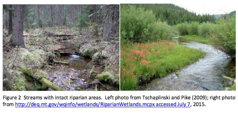
QUOTE” “Role of Riparian Habitat in Streams Why is the Riparian Area Important? Riparian areas and the vegetation and structure associated with this component of aquatic environments in streams and lakes comprise critical habitats for many species, including commercial, recreational and aboriginal (CRA) fishery fishes. A riparian zone, or riparian area, is the water/land interface between the terrestrial upland area and a river or stream (Figure 1). Plant communities along the edge of streams or lakes are usually referred to as the riparian vegetation (Figure 2). The plant community within a riparian area often is dominated by hydrophilic species, but not always (Figure 2). In British Columbia watercourses that support CRA fisheries rely profoundly on intact and functional riparian areas (viz., Forest and Range Practices Act https://www.for.gov.bc.ca/code/ Table 1; Riparian Areas Regulation http://www2.gov.bc.ca/gov/content/environment/plants-animalsecosystems/fish/riparian-areas-regulation Table 2). To reiterate, the scientific literature is very clear that riparian areas comprise critical habitats for both fishes and other species (Wenger 1999, Broadmeadow and Nisbet 2004). The role of riparian habitats is elegantly described by excerpts in the following quotes: Riparian buffers are important for good water quality [in streams]. Riparian zones help to prevent [deleterious] sediment[s], nitrogen, phosphorus, pesticides and other pollutants from C301 – Salmon River Enhancement Society 3 reaching a stream. Riparian buffers are most effective at improving water quality when they include a native grass or herbaceous filter strip along with deep rooted trees and shrubs along the stream. Riparian vegetation is a major source of energy and nutrients for stream communities. They are especially important in small, headwater streams where up to 99% of the energy input may be from woody debris and leaf litter. [Invertebrates associated with this and instream vegetation contribute as fish food.] Overhanging riparian vegetation keeps streams cool, [and] this is especially important for…mountain trout [i.e., salmonid] populations. Riparian buffers provide valuable habitat for wildlife. In addition to providing food and cover they are an important corridor or travel [path]way[s] for a variety of wildlife. Forested streamsides benefit game species [e.g., deer and bear]…and nongame species like migratory songbirds. Riparian vegetation slows floodwaters, thereby helping to maintain stable streambanks and protect downstream property. By slowing down floodwaters and rainwater runoff, the riparian vegetation allows water to soak into the ground and recharge groundwater. Slowing floodwaters allows the riparian zone to function as a site of sediment deposition, trapping sediments that build stream banks and would otherwise degrade our streams and rivers. [http://www.bae.ncsu.edu/programs/extension/wqg/sri/riparian5.pdf Accessed 6 July 2015.] The critical nature of riparian areas to a properly functioning stream cannot be overstated. As Tschaplinski and Pike (2009), in their analysis of the function of riparian areas to British Columbia streams, point out “No other landscape features within forests provide linkages that are as extensive and complex as those provided by riparian ecotones.” Tschaplinski and Pike (2009) go further to indicate that riparian areas contain and support many of the highest-value resources in natural forests and quote Hartman and Scrivener (1990) as evidence. In another citation, Gregory et al. (1991) indicate that the plant and animal communities in riparian areas frequently have the highest species richness found in forests. The issues relating to riparian areas are particularly relevant to the Trans Mountain Expansion Project (TMEP) as many of the streams crossed by the pipeline construction are typical of the watercourses that Tschaplinski and Pike (2009) and others refer to in respect to the importance of the role of riparian vegetation and the zone as fish habitat. And riparian areas are key habitats that TMEP will destroy as a function of crossing the streams where trenching will take place.See the full PDF:Ripariandefinition-_IR_From_Salmon_River_Enhancement_Society_to_Pipeup_-_A4Q7W6_SRES_RESPONSE_compressed_-_A4R4F2

riparianareas

Herring Spawn Video from Denman Island

Why are BC residents so concerned about what might happen to their coastline from an increase in shipping and oil tankers?

We don’t have a scene like this video portrays in Metchosin, although we do get frenzy feeding by birds and mammals in the fall at Race Rocks but we do have forage fish which live on our beaches and provide year round food for the ecosystem.

Don’t miss this video from Denman Island : https://vimeo.com/121960894?fb_action_ids=10153160722717497&fb_action_types=

Tower Point Subdivision

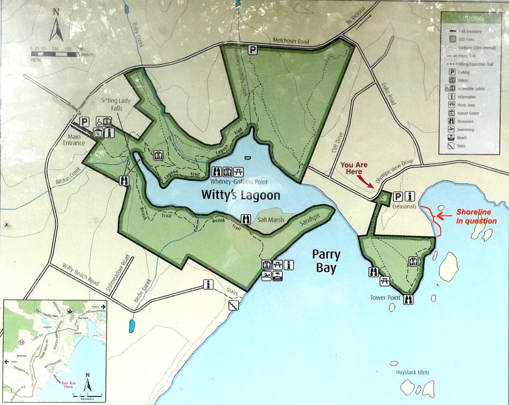
I went over to Tower Point today to get a better sense of the seafront north of the Tower Point portion of Witty’s lagoon CRD park. It is part of  a subdivision proposal. This is a good example of natural Capital of the Municipality. Public access to this area would be possible by all of the other holders of property in the subdivision, as well as the public. With the pressures from increasing population in the neighbouring communities of Langford and Colwood the value of this area kept as public property would be very high.
2015-04-13 towerpointproperty

The shorefront on the property north of Tower Point which  is subject to a subdivision proposal

From an APRM newsletter:
Parkland Acquisition at Subdivision: Under section 941 of the Local Government ACT, the owner of land being subdivided must provide park land when three or more additional lots are being created and at least one of the parcels is 3 Hs(4.94 acres) or smaller.  The amount of parkland that is required, without compensation, is 5% of the land being proposed for subdivision….where the local govenment has the authority to decides whether it wants 5% deducation or cash-in-lieu, it is up to Council (unless specifically delegated to the Approving Officer) to determine the amount (up to 5%) and location.
…where the OCP has policies and designations for future parks, the local government can decide whether to accept land or cash-oin-lieu  Absent such policies, the landowner decides, with the compensation equal to market value of the entire parcel prior to its subdivision but it has preliminary approval for subdivision…
towerpointmap

The shoreline location— see red arrow and bracket on the right.

The shorefront here would make a very good addition to the part of Witty’s Lagoon regional park which is locted at Tower Point . Residents of the community made a submission at tonight’s council meeting pointing out the advantages of a park dedication for a strip along the shoreline. It is hoped that the council, when provided with the final version of the application will recommend this park border extension.

I also took some pictures of the wildflowers and features of the shoreline in the park at Tower Point bordering this subdivision. See in the next blog.

Why Sand Is Disappearing ( from beaches)

beachlooknorth

The heavily impacted Weir’s Beach which has experienced considerable sand loss in recent years largely due to bad management of the shoreline.

This article highlights a good example how human interference ( anthropogenic) in a number of ways can result in the loss of Natural Capital and long term sustainability . 

The beaches of Metchosin are not immune  to the forces of Climate change and uninformed decisions of upland landowners and municipal governments which refuse to enact rigid Shoreline Development Bylaws. 

This has been quoted  from: The NYT Opinion Pages    NOV. 4, 2014

” BERKELEY, Calif. — To those of us who visit beaches only in summer, they seem as permanent a part of our natural heritage as the Rocky Mountains and the Great Lakes. But shore dwellers know differently. Beaches are the most transitory of landscapes, and sand beaches the most vulnerable of all. During big storms, especially in winter, they can simply vanish, only to magically reappear in time for the summer season.

It could once be said that “a beach is a place where sand stops to rest for a moment before resuming its journey to somewhere else,” as the naturalist D. W. Bennett wrote in the book “Living With the New Jersey Shore.” Sand moved along the shore and from beach to sea bottom and back again, forming shorelines and barrier islands that until recently were able to repair themselves on a regular basis, producing the illusion of permanence.

Today, however, 75 to 90 percent of the world’s natural sand beaches are disappearing, due partly to rising sea levels and increased storm action, but also to massive erosion caused by the human development of shores. Many low-lying barrier islands are already submerged.

Yet the extent of this global crisis is obscured because so-called beach nourishment projects attempt to hold sand in place and repair the damage by the time summer people return, creating the illusion of an eternal shore.

Before next summer, endless lines of dump trucks will have filled in bare spots and restored dunes. Virginia Beach alone has been restored more than 50 times. In recent decades, East Coast barrier islands have used 23 million loads of sand, much of it mined inland and the rest dredged from coastal waters — a practice that disturbs the sea bottom, creating turbidity that kills coral beds and damages spawning grounds, which hurts inshore fisheries.

The sand and gravel business is now growing faster than the economy as a whole. In the United States, the market for mined sand has become a billion-dollar annual business, growing at 10 percent a year since 2008. Interior mining operations use huge machines working in open pits to dig down under the earth’s surface to get sand left behind by ancient glaciers. But as demand has risen — and the damming of rivers has held back the flow of sand from mountainous interiors — natural sources of sand have been shrinking.

One might think that desert sand would be a ready substitute, but its grains are finer and smoother; they don’t adhere to rougher sand grains, and tend to blow away. As a result, the desert state of Dubai brings sand for its beaches all the way from Australia.

And now there is a global beach-quality sand shortage, caused by the industries that have come to rely on it. Sand is vital to the manufacturing of abrasives, glass, plastics, microchips and even toothpaste, and, most recently, to the process of hydraulic fracturing. The quality of silicate sand found in the northern Midwest has produced what is being called a “sand rush” there, more than doubling regional sand pit mining since 2009.

But the greatest industrial consumer of all is the concrete industry. Sand from Port Washington on Long Island — 140 million cubic yards of it — built the tunnels and sidewalks of Manhattan from the 1880s onward. Concrete still takes 80 percent of all that mining can deliver. Apart from water and air, sand is the natural element most in demand around the world, a situation that puts the preservation of beaches and their flora and fauna in great danger. Today, a branch of Cemex, one of the world’s largest cement suppliers, is still busy on the shores of Monterey Bay in California, where its operations endanger several protected species.

The huge sand mining operations emerging worldwide, many of them illegal, are happening out of sight and out of mind, as far as the developed world is concerned. But in India, where the government has stepped in to limit sand mining along its shores, illegal mining operations by what is now referred to as the “sand mafia” defy these regulations. In Sierra Leone, poor villagers are encouraged to sell off their sand to illegal operations, ruining their own shores for fishing. Some Indonesian sand islands have been devastated by sand mining.

It is time for us to understand where sand comes from and where it is going. Sand was once locked up in mountains and it took eons of erosion before it was released into rivers and made its way to the sea. As Rachel Carson wrote in 1958, “in every curving beach, in every grain of sand, there is a story of the earth.” Now those grains are sequestered yet again — often in the very concrete sea walls that contribute to beach erosion.

We need to stop taking sand for granted and think of it as an endangered natural resource. Glass and concrete can be recycled back into sand, but there will never be enough to meet the demand of every resort. So we need better conservation plans for shore and coastal areas. Beach replenishment — the mining and trucking and dredging of sand to meet tourist expectations — must be evaluated on a case-by-case basis, with environmental considerations taking top priority. Only this will ensure that the story of the earth will still have subsequent chapters told in grains of sand.

Ecologically Sensitive Areas of Coastal Metchosin

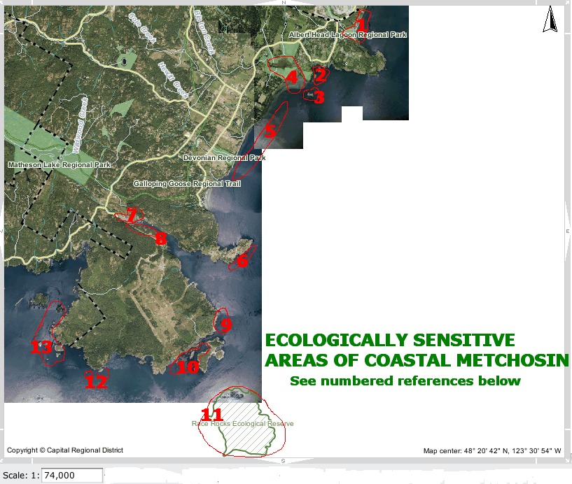
Most of Metchosin’s shorelines could be considered as “Ecologically Sensitive” . The areas identified below however have a particularly high level of sensitivity.

ecoareas
This list does not necessarily include all ecologically sensitive areas. Arguments could be made for the complete coastline being ecologically sensitive.
1. Lagoon with shorebird habitat, sensitive dune vegetation on sand shore.

2. Coastal Islands with harbour seal haulouts

3. Harbour seal haulout

4.Coastal lagoon, migratory and resident seabird habitat.

5. Eel grass beds offshore.   Also see:
Sensitive dune vegetation on sand shore.

6. High current invertebrate community

7. Estuary, mudflat habitat for overwintering shorebirds.

8. Cormorant winter roosting colony.

9. Kelp bed for fish spawning and seabird habitat. Great blue herons often feed from the kelp

10. High current channel with harbour seal haulouts and winter feeding grounds for seabirds, some migratory. Western Grebes and Buffleheads frequent the area in winter.

11. High current area, with significant invertebrate colonies, kelp beds, a rockfish protection area, marine mammal haulout and seabird nesting and overwintering habitat.

12. Island ecosystems, swept with strong currents bearing significant invertebrate colonies.

13. Island ecosystems with significant invertebrate and kelp beds.

Return to the anthropogenic impact index
Return to the sector map index
Return to the MetchosinCoastal website Home Page


A new Lease on Life for the Rare Marsh Plant: Phragmites australis subsp. americanus–A note of caution when attempting to control Invasive Species

By Garry Fletcher, Metchosin, British Columbia

goochcreekpops

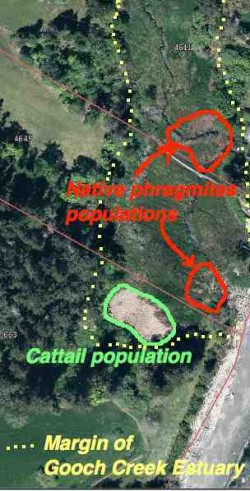
The yellow dots show the margin of the Gooch Creek Estuary. The populations of native Phragmites are shown in red. Location: 48deg,22′,11.01″N—123deg 31’52.19″ W.


Introduced species are no doubt one of the most serious challenges for us in the effort to preserve ecological integrity*. Occasionally however we can mete out  a death sentence to an innocent which can have serious consequences.  This post is about one such occurrence with the native marsh/estuary grass Phragmites australis (Cav.) Trin. ex Steud. subsp. americanus

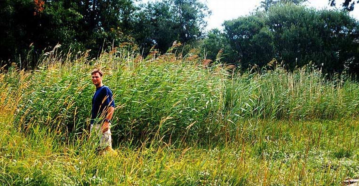
When we first bought our property on William Head Road, I was intrigued with the variety of ecosystems that could fit into one small 4 hectare piece of land. One such ecosystem was the  seasonally flooded salt marsh at the foot of the property. In that marsh were two populations of a very tall (2-3 metre) marsh reed grass.

In the mid-1980s, I asked one of our members of * MEASC, Robert Prescott-Allen to identify the species for me and he came up with the genus name Phragmites. He indicated that it used to be more common in our coastal estuaries, but it had been destroyed in the early years with cattle trampling and grazing. Now it only occurs in limited  populations in BC and in some populations along the Oregon Coast.

When I made the website MetchosinCoastal , I included a profile on the marsh with images of this plant on the Taylor Beach/Gooch Creek page . phragmiteskalleFast forward twenty years or so until 2009. I received a call from the Invasive Plant EDRR Coordinator | B.C. Ministry of Forests, Lands & Natural Resource Operations
PO Box 9513, 8-727 Fisgard St, Victoria B.C. CANADA V8W 9C1. She indicated that there were 9 populations of the introduced species Phragmites australis (Cav.) Trin. in BC and it was their mandate to control all of them. She came out to the farm, took samples and pictures and I sent her pictures of the extent of the grass in the marsh over the last few years indicating it really hadn’t spread that much. She made reference to a sample in the RBC museum which had been collected from our pond in 1992 which was identified as the introduced variety.

She indicated she would be out with a crew in the fall to cut the plants to the ground and spray with the herbicide Glyphosate . (and this being next to a sea-run cutthroat stream!)

On their website, the locations of this plant in BC were identified .  When the call came that they were coming out, I started to do research on the species.  I valued this plant as a great nesting habitat for red-winged blackbirds, and in the summer they get infested with aphids, providing food to wasps, marsh wrens and other birds. In addition, the hollow stems made excellent homes for Mason Bees.

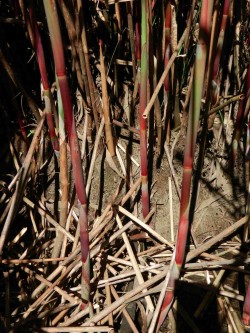
2013-05-15redstem3

The red stems mentioned on the Oregon ID website are visible in the growing season on our population of reeds. I checked in early Dec.2013 and the red color is still visible.

I referred to a website from the Government of Oregon, which gave a comparison on the physical features of native , (Phragmites australis subsp.americanus) and introduced species samples. It looked very much like the native species to me, with most of the morphological characteristics corresponding. It also indicated that DNA analysis of tissue samples was the only definitive way to determine the genotype of the species.

I also contacted Dr. Adolf Ceska for his opinion, he indicated that the invasive variety probably came into BC in the 1980s. This population in our marsh was well established before the 1980s, and has not progressed very much since then. It is in a seasonal estuary, it floods with fresh
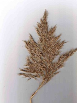
This species reproduces both asexually by underground rootstalks as well as sexually by seeds born on panicles such as this.

This species reproduces both asexually by underground root-stalks as well as sexually by seeds born on panicles such as this.

water with heavy winter rains,  but only gets flooded with a salt water intrusion at high tides driven by a east-wind driven storm surge. (winter only)

phragmitestassleoct13I tend to think that the salt water controls its distribution  somewhat in this particular marsh.  Interestingly,  in recent years cattails have spread  in the pond and they were previously also controlled by salt water. The main invasive in the marsh is reed canary grass.

I told the  Invasive Plant EDRR Coordinator when she showed up with her crew of two to “remove it”  that I would not allow it unless it was proven to be the invasive by DNA analysis.  I heard back from her in the spring 2014.
Phragmites australis subsp. americanus growing in the Gooch Creek marsh

Phragmites australis subsp. americanus growing in the Gooch Creek marsh (in November) of the year

In December of 2013, I was contacted by a wetlands restoration company from Nanaimo, BC about the population, as  they found out from the RBC museum that our population was the native variety. I had not heard this yet so I contacted Dr. Ken Marr at the museum, and he indicated that DNA tests had been done and that it was indeed the native species.


  • He writes “At this very moment I happen to be at UVIC looking at the raw data from the DNA analysis that was mostly completed a year ago.  We have been doing a parallel study of morphology and DNA of 140 or so samples of Phragmites.  Long story short, we have determined from the DNA analysis, that the populations on your land are the native genotype.  In fact, the analysis of the the sample from your land convinced the coordinator of the value of doing the DNA analysis since she had thought the plants on your land were the invasive genotype. Her conclusion may have been based upon my tentative ID of a specimen collected in 1992(?) from your land and that I thought to be the invasive genotype using the characters that have been used to distinguish the native from the invasive. All who have worked on this group acknowledge that for some individual plants, it is difficult to be certain which genotype to which a plant belongs, however DNA markers are viewed to be unambiguous.”
So having regained its “native species” reputation it is protected. The moral of the story is that we must not act impulsively on eliminating introduced species unless we are absolutely certain of the species, and in the case of Phragmites, DNA testing is a minimum requirement before extirpation is promoted.
This has ben published in the BEN ( Botanical Electronic Newsletter)  http://bomi.ou.edu/ben/ben475.html
  • One value added  aspect of the dead hollow stems of Phragmites australis subsp. americanus is that they make great Mason Bee homes. The bottom metre and a half of the larger stems have internode lengths of up to 20 cm, and the inside diameter of the stems is 8 mm.

REFERENCES:

1.BEN , Botanical Electronic News: References on the identification of native and introduced varieties of Phragmites
2. Native to North America or introduced (or both)?
Information on the Morphological Differences between the Native and Introduced
3. Saltonstall, K., Burdick, D., Miller, S., and Smith B. 2005.  Native and Non-native Phragmites : Challenges in Identification, Research, and Management of the Common Reed,  National Estuarine Research Reserve Technical Report Series 2005. (This publication has a good set of comparative photographs of the two varieties.)
4. Swearingen, J. and K. Saltonstall. 2010. Phragmites Field Guide Distinguishing Native and Exotic Forms of Common Reed (Phragmites australis) in the United States. Plant Conservation Alliance, Weeds Gone Wild.
5. from The Encyclopedia of Earth,   Phragmites australis – cryptic invasion of the Common Reed in North America, “Kristin Saltonstall of the Smithsonian Tropical Research Institute has conducted a series of groundbreaking genetic analyses on P. australis. Her research has identified 29 unique genetic types, or haplotypes, of the grass globally. Of these, 13 are native to North America and historical pre-1910 samples indicate a wide distribution of these native haplotypes across the continent. Modern sampling has revealed the widespread presence of a non-native haplotype growing throughout North America. This newcomer’s DNA matches that of a Eurasian haplotype that is the most common P. australis haplotype in the world.”

Kingdom Plantae – plantes, Planta, Vegetal, plants
Subkingdom Viridaeplantae – green plants
Infrakingdom Streptophyta – land plants
Division Tracheophyta – vascular plants, tracheophytes
Subdivision Spermatophytina – spermatophytes, seed plants, phanérogames
Infradivision Angiospermae – flowering plants, angiosperms, plantas com flor, angiosperma, plantes à fleurs, angiospermes, plantes à fruits
Class Magnoliopsida
Superorder Lilianae – monocots, monocotyledons, monocotylédones
Order Poales
Family Poaceae – grasses, graminées
Genus Phragmites Adans. – reed
Ed. Note: Species subspecies americanus is the native species
in North America. Phragmites australis (Cav.) Trin. ex Steud. – common reed
-introduced species in North America

See posts on the use of Phragmites stems for culturing Mason Bees here:http://www.gfletcher.ca/?tag=phragmites


Sharing our Shoreline

Values and Views
Island Trust Communities
Marine By Nature
The Islands within the Salish Sea have been  shaped by ancient glaciers and modern oceanic forces. Whether you visit the islands seasonally or live here year round, Islanders treasure the marine environment.  The North Pender Local Trust Committee has developed this brochure to introduce you to where sensitive marine habitats exist, how you can recognize them, and what simple steps you can take to ensure our local waters continue to support a vibrant and abundant marine ecosystem.

This PDF has been produced by the North Pender Island Local Trust Committee: Sharing Our shorelines_lowres

IslandstrustContents:

Clean Water
Shoreline erosion
Coastal Bluffs and Shoreline beaches
Marine Riparian Vegetation
Intertidal Habitats
Beach-spawning Forage Fish
Eelgrass habitats
Kelp Forests and Rocky Reefs
Marine shorelines as critical fish habitats

Overhanging Vegetation, Invertebrates and Forage fish

Development along shorelines can very easily destroy or alter the natural coastal ecosystems so that the food supply and habitat maintenance of Forage Fish is affected negatively. Ramona de Graff has made several presentations on the importance of Forage Fish and has encouraged local residents to join in the documentation of occurrence of eggs on beaches.
From The Islands Trust “Sharing our Shorelines”
page 6: Shorelines Connect – Linking The Land And The Sea
Marine Riparian Vegetation
What is marine riparian vegetation?
The term “marine riparian” vegetation refers to grasses, shrubs, trees and logs lining marine shorelines. Marine riparian zones link the land and the sea through the exchange of water, sediments and nutrients.
Where is marine riparian vegetation located?
Vegetation above the high water mark, within “backshore” areas such as
private shoreline properties, on bluff tops and slopes form the marine
riparian zone.
Why is marine riparian vegetation important?
Insects captured by the winds as “wind fall” from shoreline vegetation are critical
for young salmon growth. Removing overhanging shoreline vegetation from summer
surf smelt spawning beaches causes embryos to die. Vegetation removal reduces key prey for juvenilesalmon and can reduce surf smelt populations. Fish losses affect the entire food web. Vegetated buffer zones are a wildlife migratory corridor and leaf litter provides nutrients to stimulate marine plankton growth.
Maintaining shoreline vegetation is a net benefit to property owners as a free
“ecosystem service” limiting erosion and stabilizing slope soils. Trees and
shrubs absorb large volumes of rain water and filter pollutants. Vegetation
removal may cause large sediment loads to enter the ocean limiting light for eelgrass growth and clogging fish gills.
See also on this website: Land Plants of Coastal Metchosin.