Metchosin Shoreline Report : MEASC 2013

The Metchosin Environmental Advisory Select Committee of  Metchosin District submitted this report to Council in June  2013.

See the complete report as a  PDF: Metchosin Shoreline Report 2013June 10-2

Executive Summary

The unique values attributed to the Coastal Areas of Metchosin have been recognized both historically and by outside researchers. They have also been outlined at length in the Official Community Plan and other documents produced for the District.

The objective of the Metchosin Shoreline Report is to provide Mayor and Council with a background document and decision-making tools for issues related to Metchosin’s shoreline environment: the jurisdictional boundaries are delineated; examples of ecologically sensitive areas are highlighted; and the biological and geographical values of eight zones of the forty-five km of shoreline are profiled.

The values of biodiversity, education, natural capital, aesthetics, philosophy, and ecotourism are all affected by our coastal areas. Therefore, the risks from human activity on the sustainability of these areas are emphasized.

With the increasing likelihood of changing climatic events impacting on our shoreline, and in order to mitigate these risks, a number of recommendations are proposed for the Municipality to implement:

  1. Create a development permit zone in the area between the end of provincial jurisdiction at the high water mark and the end of the high tide storm-driven wash on the landowner’s property.
  2. Prevent the human caused hardening of the shoreline by sea walls, roadways or bulkheading, and shoreline modifications.
  3. Design a “Coastal Covenant,” which landowners could sign, in order to guarantee the protection of the integrity of their section of shoreline.
  4. Establish and protect vegetation buffer zones along streams and along the total shoreline, including special attention to salt marshes and eelgrass beds.
  5. Protect eelgrass beds by eliminating damage from log booms, docks and other structures.
  6. Divert runoff of fertilizers, pesticides and herbicides from streams and surrounding farmlands away from shoreline, salt marsh, and seagrass habitats.
  7. Develop emergency response plans for the District in the event of a land or ocean-based toxic spill, which could potentially threaten the shoreline.

See the complete report as a  PDF: Metchosin Shoreline Report 2013June 10-2


District of Metchosin Official Community Plan Section on Shoreline Slopes Development Permit Areas

From the Official Community Plan : Available at this link

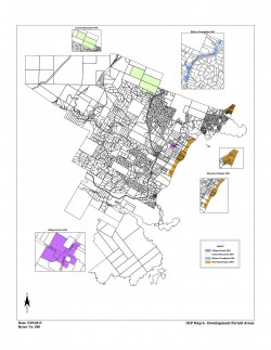
Map6_Development_Permit_Areas

DPAs in Metchosin ( click to enlarge)

2.16    SHORELAND SLOPES DEVELOPMENT PERMIT AREAS:
The Municipal Act
provides that a community plan may designate development areas to be protected from hazardous conditions. The Municipal Act further provides that in such areas land shall not be altered in any way or subdivided and structures not be built or added to until a Development Permit has been  issued. Council has established the following designation, special conditions, and guidelines.

2.16.1    Designation:  (Bylaw 418, 2004)
The 1993 Hazard Land Management Plan has identified areas of the Metchosin shoreland slopes as having erosion, land sloughing and drainage problems.

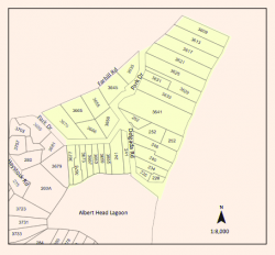
AlbertHead portion of DPAs

Farhill Road portion of DPAs,

southsectionDPA

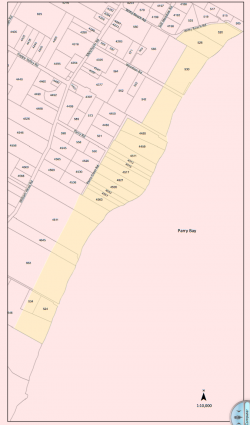
Parry Bay ( Taylor Beach ) section of DPA lands

The Shoreland Slopes areas are shown on Map 6 Shoreline Slopes DPA, and are hereby designated as areas for the protection of development from hazardous conditions pursuant to Section 919.1(1)(b) of the Local Government Act.
The Plan has identified three Shoreland Slope classification zones, based on the degree of slope instability and surface erosion potential. Slopes classified as zone 2 and 3 are slopes with the greatest potential for sloughing, slumping and debris flows and have been included in the Development Permit Area.
2.16.2    Special Conditions:
The major concern is that lands, particularly in the Park Drive – Farhill Road area, have experienced a  dramatic rise in ground water levels due to adjacent developments during the last two decades. Other areas of the Shoreland slopes have experienced significant slope erosion in the past. There is a community desire to mitigate any further development related impacts on the marine shorelands.

2.16.3    Policies Development Permits issued shall be in accordance with the following:
(1)    The construction or alteration of buildings on existing lots shall be permitted subject to the Building  Permit process when Council is satisfied that the Development Permit Guidelines (Section 2.14.4) have been met, and, when required, Council is satisfied with the Engineer’s Report (Section 2.14.5).
(2)Where a Development Permit is applied for in conjunction with an application for subdivision approval, rezoning, or both, the Development Permit shall be conditional on the successful completion of those other permits and shall lapse if the subdivision or rezoning is not approved.

2.16.4    Guidelines:
(1)    All applications for new development in the Development Permit Areas shall be required to have an Engineer’s Report (described below).
(2) Removal of vegetation shall be minimized.
(3) House construction, regrading, and excavation of till (including for road building) is not permitted within 60 metres of the edge of the slope except where geotechnical engineering and resource management studies indicate that a lesser setback is acceptable.
page 31

2.16.5    Engineer’s Report:
Before a development permit is issued, the applicant shall be required to furnish a report at his\her expense from a registered professional engineer with geotechnical experience which will certify that the proposed development will produce no adverse impacts on the shoreland slopes and will not place buildings or structures in danger of slope slippage.

The Engineer’s Report shall demonstrate that consideration has been given to the following:
(1)(a) siting and setbacks of development structures, roads, and services,
(b) minimizing paving and impervious materials, and,
(c) implementing infiltration techniques so as to limit runoff;
(2) designing runoff detention ponds, drainage works, or
sediment traps or basins to reduce the flow of  runoff and silt during land clearing and construction.
(3) development near shoreland slopes must address the impact of surface water on slope stability, vegetation and soils, and make recommendations to remedy that already damaged; and
(4) removal of trees (with a valid tree-cutting permit) or other vegetation should be allowed only where  necessary and where alternate vegetation and/or erosion control measures are established. If possible,  stumps should be left in place to provide some soil stabilizing influence until alternative vegetation is  established. Plans delineating extent of vegetation/tree removal (location, species and diameter of trees) and location of proposed construction, ex cavation and/or blasting, may be required.

The DISTRICT, at its discretion, may also submit the Engineer’s Report to review by a second Engineer at the applicant’s expense, and/or directly to the Ministry of Environment for their comments.

2.16.6    Municipal Response, 
The DISTRICT should:
(1) evaluate the feasibility of purchasing environmentally sensitive shorelands for use as park, forest reserve, or greenbelt;
(2) initiate programs to monitor both surface and ground water to establish patterns of change;
(3)work with proximate agencies to establish erosion and land sloughing control measures.

The Green and Blue Spaces Strategy, December, 2007

The PDF of this report from  2007 may be viewed in it’s entirety here:
Blue-green-spaces-Document

Note in particular: page 4 : TYPES OF GREEN and BLUE SPACES

part 5. Marine Areas.

a. Nearshore marine areas: These areas  occur along the coastlines of Metchosin. They are productive nursery areas and habitat for marine life, and include eelgrass beds, kelp beds, and subtitle rocky areas.

b. Marine shorelines: these are areas of natural shoreline on land. They are an important part of the scenic character of the community, contain recreational trails or beach access points, and provide a buffer between buildings and natural dynamic processes such as shoreline erosion. Examples include rocky marine shorelines and beaches [especially between Helberg had and church island], tidal lagoons, estuaries and offshore islands.

Under recommendations  —Municipal governments:

  •   while Metchosin has no formal management responsibility for nearshore marine areas, we should continue to acquire and maintain inventories of these areas, and have municipal input into provincial and federal government decisions regarding their management.
  • Recognize the importance of and encourage the protection and restoration of Metchosin’s natural shoreline.

Link: The CRD Blue-Green report


District of Metchosin Official Community Plan Section on Marine Shorelands

Documents Presented in the past to Metchosin Council
There is a history of concern about the values associated with the coastal part of Metchosin, the following examples illustrate this.

From  the Official Community Plan of Metchosin, the following references pertain to Marine Shorelands.

Section 2.6 MARINE SHORELANDS:

Definition: Within Metchosin, there are Rocky Shores, Drift Sector Beaches, Pocket Beaches, Low- Energy Shores and Lagoon Ecosystems, as shown on Marine Shorelands, Map 5. In addition, the two types of beaches are further categorized into three distinct classes of beach based on the accretion and erosion characteristics. The combinations of shore categories and distinct beach classes produce a diverse range of marine shorelands. Most of the geotechnical and environmental concerns about shores relate to the processes of drift and accretion along the shore and the process of slope regression above the shores.

(a) General Marine Shoreland Policies:

2.6.1 The District of Metchosin may give consideration to the following:

.    (1)  discuss with senior levels of government for coordinating future land use policies as they pertain to the management of Metchosin’s marine shorelands.

.    (2)  monitor shore processes with particular concern for slope regression rates,lateral drift rate and stability of Class I accretion beaches.

.    (3)  determine,in conjunction with the Ministry of Environment, Lands and Parks, ways and means of undertaking:

(a)  where desirable and feasible, a program of beach stabilization using natural nonstructural techniques, such as the planting of dune grasses where appropriate;

(b)  beach enhancement programs wherever it is possible to upgrade a Class II beach to a Class I beach (see Definitions of beaches); and

(c)  the removal or reduction of development intrusions not consistent with the maintenance of the shoreline.

2.6.2. The set back requirements specified in this Section may be increased as local conditions warrant.

2.6.3  The improvement of public access should be ensured in the course of land development where such access is not detrimental to Sensitive Environments.

2.6.4  Any desired works to be placed on foreshore lands from the mean high water mark seaward requires application to the appropriate provincial and/or federal government agency responsible.

2.6.5  Public recreational use of marine shorelands should be consistent with the suitability of each shore type for the proposed use.

(b) Rocky Shores:

Definition: Rocky shores are stable shores comprised of exposed bedrock with an absence of unconsolidated material at extreme low tide. Relative to other types of shores, they are low in biological productivity but rich in biotic diversity and aesthetic quality and are characterized by lichens, snails, barnacles, mussels, seaweeds, anemones and sea stars.

.    2.6.6  No building or structure shall be located and no fill shall be placed or removed from any site within 15 horizontal metres (50 feet) of mean high water on Rocky Shore slopes except where engineering and resource management studies indicate that a lesser setback is acceptable.

.    2.6.7  Although the biological capability of Rocky Shore slopes to support life is relatively low, the natural biota may provide habitat for rare species of animal life and that value should be considered with each development proposed.

(c) Drift-Sector Beaches:

Definition: A Drift-Sector is an integrated and independently operating erosion beach system which may extend for many miles in length and be separated from adjacent drift-sectors by either natural or artificial boundaries. Metchosin contains one large drift-sector extending from Weir Beach to Witty’s Lagoon. A drift-sector generally contains the following three classes of beaches:

Class III Beaches are erosional beaches located at the base of coastal bluffs or cliffs from which sand and gravel is provided for accretion of Class I beaches further along the drift-sector. Class III beaches are totally submerged at high tide with no dry backshore berm.

Class II Beaches are marginal erosion beaches located at the base of coastal bluffs or cliffs from which sand and gravel is eroded providing a secondary source of beach material for accretion on Class I beaches further along the drift-sector. Class II beaches are largely submerged at high tide with only a limited amount of walkable dry backshore under such conditions.

– 15 –

Class I Beaches are the accretion terminals of a drift-sector where material eroded from Class II and III beaches is deposited. Class I beaches remain dry and walkable at high tide and have a large backshore berm permitting ease of public access and use. They constitute the most important recreational beaches. Biotically, beach shores are of intermediate productivity and diversity relative to the other shore types.

.    2.6.8  The use and management of the Drift-Sector Beaches should be based on the maintenance of the present natural system of erosion, transport and build up of beach material along the length of the Drift-Sector designated on Map 5.

.    2.6.9  Because the existence and maintenance of the Class I beaches are dependent on the supply of material eroded from Class II and III beaches, no bulkheading or placement of any shore protection structures will be permitted within a drift-sector except where engineering and resource management studies indicate otherwise.

.    2.6.10  To ensure that material eroded from Class II and III beaches is transported the full length of the shoreline to Class I beaches, docking or other facilities which impede the natural processes will not be permitted within drift-sectors.

.    2.6.11  Due to active slope recession with considerable sloughing and slide evidence, no building or structure will be permitted within a minimum of 60 horizontal metres (200 feet) from mean high water adjacent to Class II and Class III drift-sector beaches except where geotechnical engineering and resource management studies indicate a lesser setback is acceptable.

.    2.6.12  On the slopes adjacent to Drift Sector Beaches, no material of any kind shall be removed within a minimum of 60 horizontal metres (200 feet) landward of mean high water.

.    2.6.13  The location of the mean high water mark and the establishing of setbacks from Class II and Class III slopes should be reviewed at 5 year intervals, or as required, to determine if slope regression has placed residences at risk.

(d) Pocket Beaches:

Definition: A Pocket Beach is a sand and gravel beach along which no lateral drift of beach material takes place because it is contained between two headlands. The Pocket Beach is formed by the onshore and offshore movement of material. Pocket beaches are generally between 30.5 metres (100 feet) and 91.5 metres (300 feet) in length.

With Pocket Beaches, as with Drift-Sector Beaches, there are three classes. However, unlike the classes of Drift-Sector Beaches which are contained adjacent to one another within the Drift- Sector. Each class of Pocket Beach exists independently.

Class III Beaches are erosional beaches located at the base of coastal bluffs or cliffs with no dry backshore berm. Such beaches are totally submerged at high tide.

– 16 –
Class II Beaches are marginal erosion beaches located at the base of coastal bluffs or cliffs that supply the upper foreshore with a fairly heavy drift berm without creating a stable dry backshore zone above high tide.

Class I Beaches are rollback pocket beaches characterized by a backshore wetted only under extreme tide and wave conditions permitting ease of public access and use. They constitute the most important recreational class of beach.

.    2.6.14  No building or structure shall be located and no fill shall be placed or removed from any site within 15 horizontal metres (50 feet) of mean high water adjacent to Class I and Class II pocket beaches except where engineering and resource management studies indicate that a lesser setback is acceptable.

.    2.6.15  Because Class III pocket beaches are located at the base of cliffs which are subject to erosion, no building or structure, no placing or removal of fill or other material will be permitted within 15 horizontal metres (50 feet) landward of mean high water adjacent to Class III pocket beaches.

.    2.6.16  No bulkheading or placement of any shore protection structures will be permitted on Class I, Class II or Class III pocket beaches except where engineering and resource management studies indicate otherwise.

(e) Low-EnergyShoreZone

Definition: Low-Energy Shores are estuarine shores which form part or all of a cove or inlet. They may be characterized by marshy shores, shallow and muddy foreshores, and generally having low banks. As with Pocket Beaches, there are three classes of Low-Energy Shores each existing independently. However, in Metchosin, there is only one Low-Energy Shore – entirely a Class III (erosional) located at the head of Pedder Inlet.

Similar to a Lagoon Ecosystem, the estuarine shore also provides a unique biological environment. Fresh-water creeks and streams flowing into the cove or inlet offer rather unusual habitat. There is currently insufficient information available relating to the protection and preservation of the Low-Energy Shore zones. Therefore, further research is recommended.

.    2.6.17  No building or structure shall be located and no fill shall be placed or removed from any site within 15 horizontal meters (50) feet of mean high water adjacent to the Low-Energy Shore, except where engineering and resource management studies indicated that a lesser setback is acceptable.

.    2.6.18  No bulkheading or placement of any shore protection structures will be permitted on a Low- Energy Shore except where engineering and resource management studies indicate otherwise.
– 17 –

(f) Lagoon Ecosystems:

Definition: The central component of a Lagoon Ecosystem is a body of salt water which has been cut off from the ocean by a barrier or spit of land and which allows the formation of a sheltered biological environment. This unique environment frequently includes a salt-water marsh and estuarine area into which flows fresh water from upland creeks and streams. This combination of fresh and salt water has very high biological productivity and diversity. It offers significant aesthetic and habitat attributes.

2.6.19 Only such uses as limited agriculture and low intensity recreational uses, which do not require structural intrusion, will be permitted in Lagoon Ecosystems.



Sustainability Report Marine References: 2011

In  the Sustainability Report of MEASC to Council of 2011: ( This report has been shelved by council ), The following recommendations were made:

Recommendations from Sustainability 2011 Report:

Metchosin’s existing shoreline slopes development permit area, large lots and low density zoning have helped to reduce development impacts along coastlines, and have protected marine coastal habitat and its ability to store and sequester carbon.

Metchosin will help achieve sustainability and resiliency in its coastal areas by implementing the following:

  • Lobby senior governments to recognize that municipalities are often the first to notice problems along their marine coasts and municipalities need the authority to protect these ecosystems;
  • Consider zoning all marine shorelines in Metchosin as a development permit area in order to protect their natural values;
  •  Establish a program to document and monitor coastal resources, including eel-grass and kelp beds, and forage fish habitat, with the goal of ensuring no net loss of those resources;
  • Identify and map areas important to forage fish and consider a method of restricting beach fires and other damaging activities in these areas at times of the year which are sensitive for forage fish.
  • Emergency Preparedness Program – know who to contact, how, when where, why and in what circumstances
  • Produce a pamphlet and  to help educate both .the public, and land \owners with property bordering on the shoreline, of the sensitivity of coastal ecosystems, in order to reduce harmful impacts on coastal ecosystems.
  • Post essential messages from and distribute Transport Canada’s boaters guide at key locations to educate public.  


The Metchosin Biodiversity Strategy

PURPOSE: This draft document was prepared in the 1990s by local resident and International authority on Biodiversity Strategies, Robert Prescot Allen. Modifications and input from the Metchosin Advisory Commission and the students of the Environmental Systems class at Lester B. Pearson College have been included.  The purpose of the strategy is to enable the Council and residents of Metchosin to fulfill the commitments to conserve biodiversity as expressed in the Official Community Plan.

We welcome any comments and seek input on how this may be improved.


RATIONALE FOR A BIODIVERSITY STRATEGY FROM THE OCP:( Official Community Plan)

2.2.2 To promote the conservation of the biodiversity of the district – the variety of natural communities, native wild species and populations, and domesticated species and populations.

2.2.3 To maintain creeks, streams and inland wetlands in their natural state, by minimizing the impact of development.

2.2.4 To maintain uplands, forested lands and areas with old growth Douglas Fir in their natural state, by minimizing the impact of development.

2.2.5 To manage marine shorelands in a manner compatible with the biological and physical processes acting on and within them.

2.2.6 To identify and preserve sensitive natural environments for future generations and to maintain sufficient lands in their natural state so that rare and diverse plant and animal life will continue to exist and flourish.

2.2.9 To promote the restoration of marginal agricultural and /or previously degraded land to wildlife habitat.

Commitments to conserve biodiversity may also be found in the OCP’s general environmental policies and policies on lakes, creeks and streams; inland wetlands; marine shorelands; wildlife habitat; unique and attractive vegetation and tree cover.

The Garry-Oak Douglas fir zone is probably the most threatened ecological region in North America. It is restricted to southeastern Vancouver Island, The Gulf and San Juan Islands, The Puget trough and Willamette valley ( the rain shadow zone East of the mountains of Vancouver Island, Olympic peninsula and Washington/ Oregon Coast) Most of this zone has already been converted to farms and residential areas or has been heavily modified. Little natural Ecosystem remains. Municipalities that still have significant tracts of this ecological zone have something very valuable and unique. It is an obligation and service to the more urbanized municipalities and to future generations to maintain this heritage.


OBJECTIVES:

The ultimate objectives of this strategy are to:

  • Maintain viable populations of every species native to Metchosin.
  • Maintain viable samples of every natural community in Metchosin.
  • Initial priority will be given to species and natural communities that are endangered, threatened or rare nationally , provincially or regionally.

The Enabling Objectives of the strategy are to:

  1. Increase the number of residents who value native species and natural communities and are committed to conserving them.
  2. Increase social and economic incentives fore maintaining native species and natural communities.
  3. Increase legal support for maintaining native species and natural communities.
  4. Improve information on native species and natural communities of Metchosin and on introduced species that threaten them.
  5. Develop the Organizational capacity to maintain native species and natural communities.
  6. Obtain the resources required to maintain native species and natural communities.

VALUES:

Objective 1: Increase the number of residents who value native species and natural communities and are committed to conserving them.

  • Action: 1.1 Produce and distribute a leaflet describing the uniqueness and heritage value of the natural communities and native species of Metchosin.
  • Action 1.2 Prepare a high quality presentation on the uniqueness and heritage value of Metchosin’s native species and natural communities and the Biodiversity Strategy for Metchosin. This should be suitable for public gatherings and a TV presentation.
  • Action 1.3 Prepare and promote a “collaborative” style Internet site on Metchosin biodiversity, and the Biodiversity Strategy.
  • Action 1.4 Contact local schools to determine the extent of curricular involvement at present with Metchosin biodiversity. Enlist the help of teachers and students to contribute to identifying and promoting conservation of biodiversity.
  • Action 1.5 Prepare a demonstration booth for Metchosin Day which is designed to heighten public awareness on biodiversity issues of the community.
  • Action 1.6 Promote artistic performances on biodiversity themes to heighten awareness in the community.

INCENTIVES

Objective 2 : Increase social and economic incentives fore maintaining native species and natural communities.

  • Action 2.1 : Develop ways of increasing people’s self esteem and social standing if they do something to conserve native species and natural communities.
  • Institute community recognition of conservation efforts.
  • Encourage cooperation between neighbors to join up areas of greenspace.
  • Set time-lines for community achievement of greenspace designation .
  • Establish a high profile “community green map”.
  • Action 2.2 : Provide financial incentives (e.g. tax breaks) for maintaining native species and natural communities. Land dedicated to conserving native species and natural communities should be taxed at a rate low enough to encourage people to do so ( just as agricultural land is taxed at a favorable rate).

Recommended Steps: Draft a proposal

Council endorses proposal

Provincial government is lobbied to support the proposal

Lobby other municipalities to obtain support.

  • Action 2.2 : Provide financial incentives for restoration of degraded habitat. This could be done where there are agricultural areas overgrown with weedy species.

LAWS

Objective 3: Increase legal support for maintaining native species and natural communities

  • Action 3.1: Develop and implement an optimal zoning strategy for maintenance of native species and natural communities. Current zoning is not the most suitable for the conserving of biodiversity. A more flexible zoning system might help property owners dedicate land for conservation while meeting their economic priorities. The ecosystem unit should be taken into account when providing for subdivision or development. Certain ecosystem components must not be compromised if we are to maintain viable populations of native species.

Recommended steps: (I) Discuss what an optimal and achievable zoning system based on an ecosystem component approach would look like.

(ii) Prepare a proposal

(iii) Submit the proposal to Council and residents;

(iv) Amend the OCP and Land Use bylaw to accommodate biodiversity.

  • Action 3.2 Make available to property owners detailed information on the process of providing for covenants.

KNOWLEDGE

Objective 3: Improve information on native species and natural communities of Metchosin and on introduced species that threaten them.

  • Action 4.1 Prepare and maintain an inventory of native species and natural communities of Metchosin. This would be part of the Metchosin Environmental Inventory which has already been started.

Immediate needs:(i) Compile a list of native species (plants; vertebrates; macro-fungi)

(ii) Compile a list of natural communities

(iii) Identify native species of concern( endangered, threatened, rare)

(iv) Identify natural communities of concern (endangered, threatened, rare)

(v) Complete mapping of natural communities.

  • Action 4.2 Prepare a list of introduced species of concern ( i.e. that threaten native species or natural communities) and identify priority species for control.
  • Action 4.3 Identify a process for updating the inventories in order to keep information current.
  • Action 4.4 Involve all components of the community in the inventory process. Develop incentives for school children to contribute to the inventory.

ORGANIZATION

Objective 5: Improve information on native species and natural communities of Metchosin and on introduced species that threaten them.

  • Action 5.1 Form an organization of property owners and other individuals who will commit themselves to taking particular actions. (The Metchosin Organization on Biodiversity)
  • Action 5.2 Form an alliance with other community groups, service clubs, Environmental Organizations. Explain the strategy and enlist them as partners. Discuss what they and their members could do to develop and implement the strategy.
  • Action 5.3 Encourage and link up with similar activities in other municipalities.

RESOURCES

Objective 6: Obtain the resources required to maintain native species and natural communities.

  • Action 6.1 Prepare a budget for actions 1 through 6 . define preliminary targets for meeting the budget
  • Action 6.2 Ask council to commit itself to its share and front the money for actions 1.1 and 1.2 (required for fund raising and recruiting partners)
  • Action 6.3 Prepare and implement a plan to raise the balance of the budget.

SPECIAL ISSUES

Control of Introduced Species:

The introduced species that are of concern are those that because of their opportunistic nature, have a negative impact on native species and the re-establishment of native species.

  • Action 7.1 : Prepare and distribute to property owners a pamphlet emphasizing the importance of control of introduced species. Develop a recognition method for certification of areas that are free of introduced species.
  • Action 7.2 : Prepare priority plans for the removal of other introduced species that can destroy species diversity. Gray squirrels, starlings and rabbits may be appropriate candidates. Recognition may be made of some species, e.g. Blackberry that should be controlled in areas that could be rehabilitated with native species.
    For a reference on current research on Gray Squirrels see: This link. 
  • Action 7.3 : Encourage property owners to remove Scotch broom and gorse from their land. Develop an incentive scheme for broom eradication and restoration of native species.
  • Action 7.4.: The municipality of Metchosin will commit themselves to removing appropriate introduced species such as broom from their properties. Other public authorities, (e.g. BC Hydro) will be advised of the need for a control program .

Management of land to Encourage Native Species and Natural Communities.

  • Action 7.5 : Produce and distribute advice to landowners on ways they can manage their land to best encourage native species and natural communities.
  • Action 7.6 : Prepare and implement a plan for management of public lands, including right of ways, trails, to encourage native species, and to control introduced species.

PROTECTION:

  • Action 7.7 : Identify and protect by legislation priority areas in the municipality. Emphasis will be placed on the largest remaining intact areas of natural or near- natural ecosystems. Comprehensive management plans to ensure long-term protection must be done for each area.