Economic Impacts of an Oil Spill

This  recent cover story by Lovel Pratt in the Whatcom Watch Onlinehttp://www.whatcomwatch.org/php/WW_open.php?id=1795 is well worth reading for Metchosin residents .
Examples it has stated:

  • “The consequences are huge: The Department of Ecology(Washington State)  estimates that a major oil spill in the state would cost 165,000 jobs and $10.8 billion in annual economic activity.
  • However, these figures are undervalued because, in addition to being two years outdated, this estimate does not include any costs associated with the impacts of oil spills to privately owned shoreline and water-view properties.”
  • “Property owners may be required to evacuate if faced with fire danger and/or air pollution from emissions of benzene and other volatile organic compounds. If evacuation is not required, shoreline and water access could be cut back or prohibited. Water views would be spoiled by oil slicks and noisy cleanup operations, and oiled shorelines would likely be mechanically cleaned by pressure washing and bulldozing.–Property owners also face losses to assessed values. A study conducted in British Columbia revealed that privately owned properties can lose from 10-40 percent in value, and even properties near spills that are not directly affected can lose value by association.”
  • “Typical homeowner’s insurance would not provide compensation in the event of an oil spill. Pollutants are excluded in property policies unless the coverage is specifically defined to include the pollutant. According to my local insurance agent, unless a homeowner’s policy specifically covers oil spills, there would be no compensation for loss of use or loss of value resulting directly or indirectly from an oil spill. Further, it would be both difficult and most likely quite expensive to find such coverage.
  • “The Exxon Valdez oil spill, which hasn’t been completely cleaned up after 25 years, still has continuous and compounding environmental and economic impacts.8 Washington State can’t afford that tragedy. The 165,000 jobs and $10.8 billion in annual economic activity don’t accurately estimate the costs that such a catastrophe would have on the state.”
  • See the well-referenced article here: http://www.whatcomwatch.org/php/WW_open.php?id=1795
  • Thanks to Andy MacKinnon for pointing to this.

Images of Tankers and Marine Animals at Race Rocks.

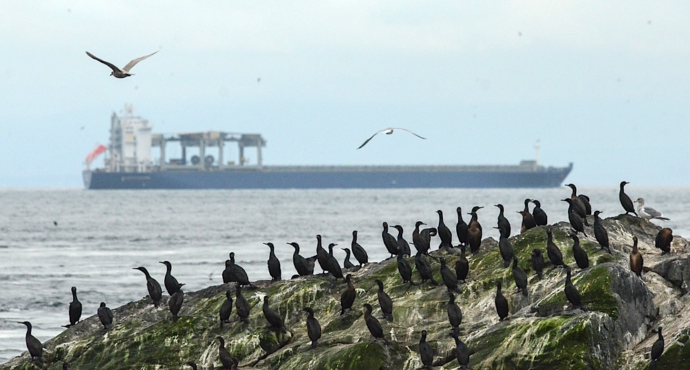
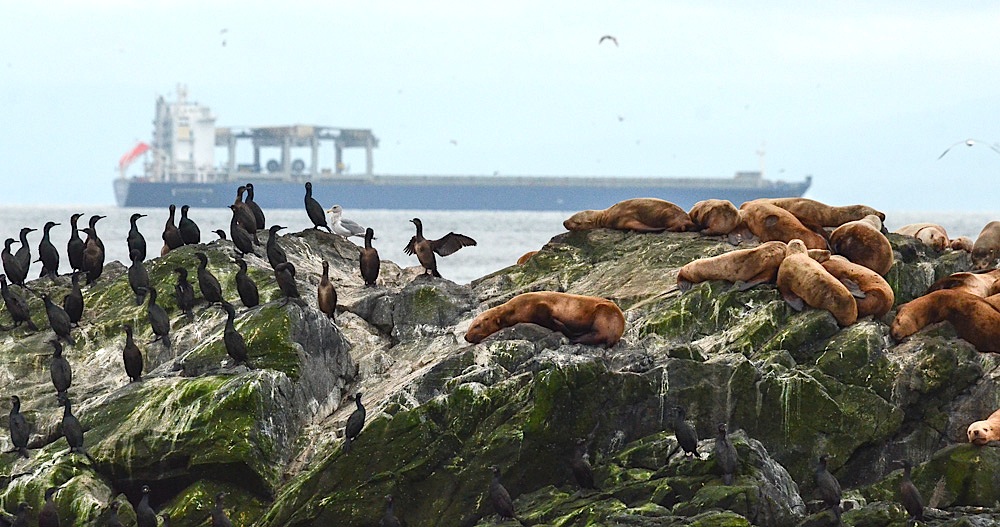
The vessel traffic lane in the Strait  of Juan de Fuca is very narrow and it llies within 3 to 5 nautical miles of the boundary of Race Rocks Ecological Reserve.  The ecoguardians at the Race Rocks Ecological Reserve have contributed photos of  the local fauna, with tankers in the background  and we have posted them on this page:

DSC_7127

Cormorants and Sealions with a 300 metre tanker in the backgound: photo by Alex Fletcher.

DSC_7137

Cormorants and Sealions with tanker in the backgound: photo by Alex Fletcher.

Letter of Support for the BC Government Motion of Dec 5 from the Board of FER

Our shoreline and Race Rocks Ecological reserve are  at risk of an oil spill. Metchosin resident Garry Fletcher and Victoria resident Mike Fenger have been Intervenors in the NEB Kinder Morgan/ Trans Mountain Pipeline Proposal Hearing  on behalf of the Board of Friends of Ecological Reserves. The letter linked here was sent in support of the Province of British Columbia’s  attempts to have full disclosure of the emergency Plans of the WCMRC (Western Canada Marine Response Corporation). ( which happens to be over 50% owned by Kinder Morgan…)

RE: Notice of Motion by the Province of British Columbia submitted December 5, 2014 OH -01- 2014 Trans Mountain Pipeline ULC (“Trans Mountain”) Trans Mountain Expansion Project (the “Project”) File Number OF-Fac-Oil-T260-2013-03 02

As an Intervenor in the above mentioned application, the Board of Friends of Ecological Reserve’s (Board of FER )provides the following comments in support for BC’s Motion submitted by the Province of British Columbia on December 5, 2014.
Please be advised that the Board of FER supports the order sought in the Province of British Columbia’s Notice of Motion dated December 5, 2014:————-

The complete text of this letter can be viewed here on the National Energy Board Website .

 Internal FER website link to this pdf:

Special Report: Tar Sands Reporting Project

Ed note: This link  is included here as an ongoing record of the problem associated with the tar sands project which has resulted in the Kinder Morgan Pipeline Expansion and the Northern Gateway Project of Enbridge.   It is an indication of the state of the Social License Oil companies have achieved with such projects.

mine-site-oil-sands_N3G4651_webSpecial Report: Tar Sands Reporting Project
From the Vancouver Observer: “
Our award-winning team’s crowd-funded series on the people, places and conflicts associated with Canada’s tar sands.”

References on Oil Spill Risk

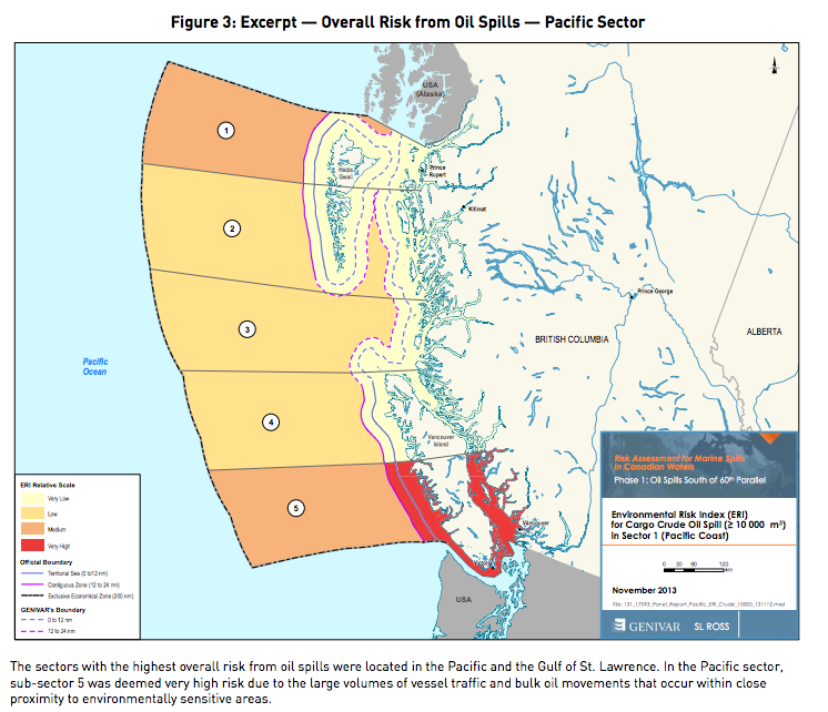
A search of oil spill risk and response shows some very useful references from the State of Washington. The PUGET SOUND PARTNERSHIP has produced an excellent study

http://www.psp.wa.gov/ FINAL REPORT: VTRA 2010

EXECUTIVE SUMMARY

Vessels transiting the Salish Sea traverse waters bordering numerous communities en route to ports in both the US and Canada. The Salish Sea is a large (over 1000 square miles) and diverse water body physically characterized by passages that are broad and deep, as well as narrow ones that are navigationally challenging with swift currents. In addition, it is a biologically rich ecosystem with significant natural resources these communities depend upon.

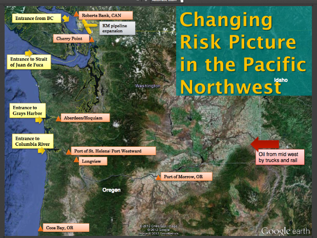
The Strait of Juan de Fuca serves as the entrance to these U.S. and Canadian ports and facilities and is transited by approximately 10,000 deep draft vessels annually including arrivals and departures. Additional transits occur internally as vessels shift locations. There are also tug and barge movements, ferry operations, fishing and recreational vessels throughout. For example, the U.S. Coast Guard Vessel Traffic Service (VTS) alone handles approximately 230,000 transits annually with about 170,000 of those being Washington State Ferries meaning there are more than 50,000 transits other than ferries. The Puget Sound Pilots report nearly 8,000 assignments annually which provide a good metric for how many deep draft vessel movements there are on the U.S. Side. ———–

While a previous GW/VCU analysis [2] of this area demonstrated significant risk reduction of oil transportation risk due to existing risk mitigation measures, the potential for large oil spills continues to be a prominent public concern heightened by proposed maritime terminal developments. In this study we focus on the following three (although other ones are under consideration) since these three are in advanced stages of a permitting process:

(1)The proposed Gateway bulk carrier terminal at Cherry Point, Washington.

(2)The Trans-Mountain/Kinder Morgan pipeline expansion in Vancouver, BC.

(3)The coal, grain and container terminal expansions at Delta Port, BC.

The purpose of this vessel traffic risk assessment (VTRA) is to evaluate potential changes in risk in light of above three maritime terminal developments and to inform the State of Washington, the United States Coast Guard and the Puget Sound Harbor Safety Committee on what actions could be taken to mitigate potential increases in oil spill risk from large commercial vessel in the VTRA study area. This study was not designed to measure the effectiveness of risk mitigation measures already in place. This study is also intended to inform tribes,local governments, industry and non-profit groups in Washington State and British Columbia on potential risk management options.

Summarizing, this study was conducted because study sponsors and involved stakeholders want to ensure potential risks of maritime development projects above are better understood so informed decisions could be made about additional risk mitigation measures that would add to the continuous improvement efforts of the past.

See the comlete pdf:http://www.psp.wa.gov/ FINAL REPORT: VTRA 2010

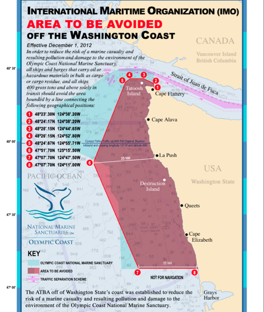
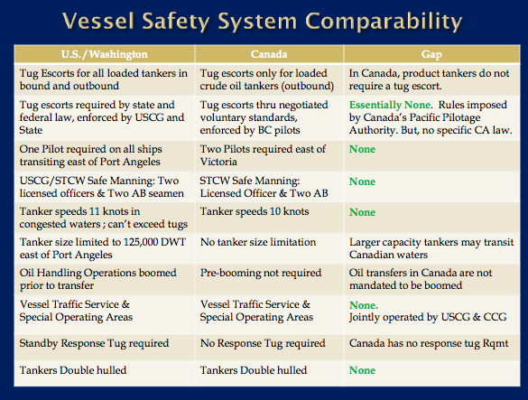
Areas to Be Avoided- Why Not in Canada Also?

When we look at the protection afforded along the Rugged coast of the Olympic Peninsula, one might quite easily question why we in Canada cannot have an equivalent level of protection for our rugged and sensitive areas.

The Olympic Coast National Marine Sanctuary is one of 14 marine sanctuaries administered by the National Oceanic and Atmospheric Administration, an agency of the U.S. Department of Commerce. It includes 2,408 square nautical miles of marine waters off the rugged Olympic Peninsula coastline.


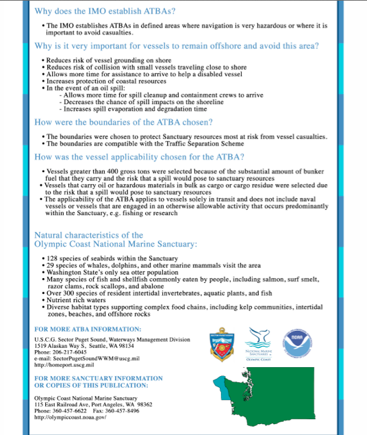
This reference provides a good explanation of the history and process of having the International Maritime Organization declare this area an ATBA, (Area To Be Avoided) Olympic Coast National Marine Sanctuary Area to be Avoided (ATBA) Education and Monitoring Program


Dave Shannon of Terrace BC has provided his notes and aid to the testimony on December 2012 which he provided as an intervenor in the cross examination in the Northern Gateway Joint review Panel.

The images below are included in the PDF:
ATBA Reference During Transcript #115 Prince Rupert Dec. 2012

ATBA-Olympicpenn1ATBA-Olympicpenn2


Federal Government Technical Report Properties, Composition and Marine Spill Behaviour, Fate and Transport of Two Diluted Bitumen Products from the Canadian Oil Sands

This report is currently available at http://crrc.unh.edu/sites/crrc.unh.ed/file/1633_dilbit_technical_report_e_v2_final-s.pdf

Federal Government Technical Report
Properties, Composition and Marine Spill Behaviour, Fate and
Transport of Two Diluted Bitumen Products from the Canadian
Oil Sands
Environment Canada
Emergencies Science and Technology
Fisheries and Oceans Canada
Centre for Offshore Oil, G
as and Energy Research
Natural Resources Canada
Canmet ENERGY
November 30, 2013
Executive Summary
Effective spill response depends on good scientific understanding of petroleum product behaviour in the environment (e.g., movement and changes in physical properties and chemical composition of the oil). This study reports the early research simulating diluted bitumen products spilled at sea. This work was undertaken by the Government of Canada as part of the first phase of a strategy to implement a world class prevention, preparedness and response regime for oil spills from ships.
The behaviour of the diluted bitumen products was studied under laboratory conditions in three phases. First, the properties and composition of two samples representative of products currently being shipped in Canada were measured before (fresh) and after (weathered) exposure to environmental conditions. Secondly, the potential for evaporation, exposure to light, mixing with saltwater, and sediments in the salt water to affect whether diluted bitumen products float or sink
in saltwater was examined. Finally, the effectiveness of two existing spill treating agents meant to disperse spilled oil products was evaluated.
This work is a collaborative effort between the Emergencies Science and Technology
Section, Environment Canada; the Centre for Offshore Oil, Gas and Energy Research, Fisheries and Oceans Canada ; and Canmet ENERGY, Natural Resources Canada. As well as the laboratory and wave-tank experiments, a literature review was conducted to identify knowledge gaps on the physical and chemical properties of conventional and non-conventional heavy oils, and their fate and behaviour in marine environments. The use and effectiveness of oil spill treating agents is
also reviewed for heavy oils. Two diluted bitumen products, Access Western Blend (AWB) and Cold Lake Blend (CLB), were selected for study as the highest-volume products transported by pipeline in Canada for 2012–2013. The physical characteristics and chemical composition of each product were m easured to aid in potential spill preparation and response.
The major results of the studies were:
  • Like conventional crude oil, both diluted bitumen products floated on saltwater (free of sediment), even after evaporation and exposure to light and mixing with water
  • When fine sediments were suspended in the saltwater, high-energy wave action mixed the sediments with the diluted bitumen, causing the mixture to sink or be dispersed as floating tarballs;  The use of the term “tarball” in this report follows convention in the literature and refers to the consistency of floating, heavily-weathered oil. It does not describe the chemical composition of the product.

Internal copy of this report:1633_dilbit_technical_report_e_v2_final-s