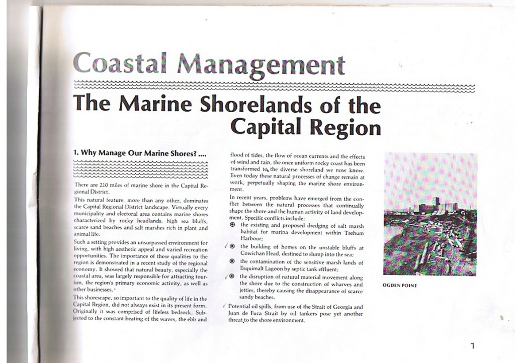
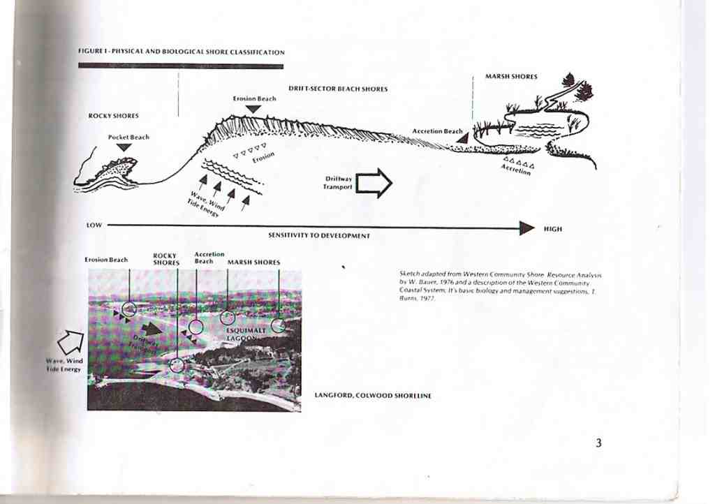
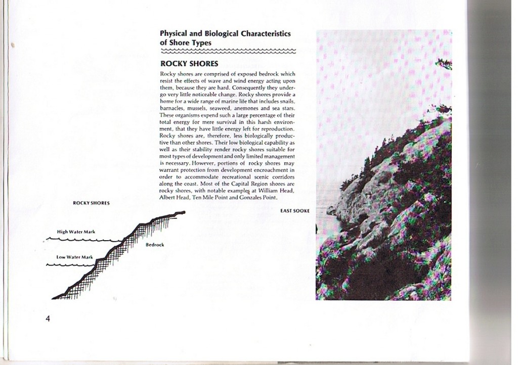
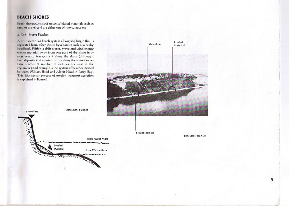
Donna Gibbs: SPECIES LIST- From: William Head, Rosedale Rocks, Race Rocks

SPECIES LIST:

Compiled by:Donna Gibbs of the Vancouver Acquarium on dives made at Rosedale Rock, West Race Rocks and William Head in the summer of 1997. Groupings are made in Phylums or Divisions.

Dive 432 – Rosedale, Race Rocks – June 12, 1997


Epiphytic red algae (Smithora, Antithamnion, Ceramium, Polysiphonia)

Iridescent blade red algae (Iridea)

Encrusting coralline algae (Lithothamnion)

Branching coralline algae (Bossiella, Corallina, Calliarthron)

Bull kelp (Nereocystis)

Blade kelp (Costaria)

Blade kelp (Alaria)

Woody-stemmed kelp (Lessoniopsis, Eisenia, Pterygophora)

 Tar spot (Codium setchellii)
 Tan finger sponge (Isodictya quatsinoensis)

Orange-red encrusting sponge (Ophlitaspongia pennata)

Thick, dark red encrusting sponge (Plocamia karykina)

Boring sponge (Cliona celata)

Crumb-of-bread sponge (Halichondria, Haliclona spp.)

 Giant black feather-duster worm (Eudistylia vancouveri)

Sand-dwelling feather-duster worm (Sabella spp.)

Slime tubeworm (Myxicola infundibulum)

Multi-colour calcareous tubeworm (Serpula vermicularis)

Honeycomb tubeworm (Dodecaceria fewkesi)

Spaghetti or shell binder worm (Thelepus crispus)

 Plumose anemone (Metridium giganteum)

Red and green or Christmas tealia (Urticina crassicornis)

Crimson anemone (Cribrinopsis fernaldi)

Brooding or proliferating anemone (Epiactis prolifera)

Zoanthid (Epizoanthus scotinus)

Ostrich-plume hydroid (Aglaophenia struthionides)

Delicate-plumed hydroid (Plumularia spp.)

Orange hydroid (Garveia annulata)

Snail-fur hydroid (Hydractinia sp.)

Pink-mouthed solitary hydroid (Tubularia marina)

Thread-like, creeping network hydroid (Orthopyxis spp.)

Pink or violet branching hydrocoral (Stylaster venusta)

Encrusting hydrocoral (Allopora petrograpta)

Tiny star jellyfish (Phialidium gregarium)

  Other encrusting bryozoan (Schizoporella spp., Microporella spp., Eurystomella spp.)

Northern staghorn bryozoan (Heteropora pacifica)

 Gumboot chiton (Cryptochiton stelleri)

California mussel (Mytilus californianus)

Rock or purple-hinged scallop (Crassedoma giganteum)

White-cap limpet (Acmaea mitra)

Rough keyhole limpet (Diodora aspera)

Snail-dwelling slipper shell (Crepidula adunca)

Leafy hornmouth shell (Ceratostoma foliatum)

Blue top snail (Calliostoma ligatum)

Heath’s dorid (Geitodoris heathi)

Coloured dendronotid (Dendronotus diversicolor)

  Sea flea (Anisogammarus spp., Orchestia spp.)

Coon-stripe shrimp (Pandalus danae)

Candycane or candy-stripe shrimp (Lebbeus grandimanus)

Kincaid’s commensal shrimp (Heptacarpus kincaidi)

Giant or giant acorn barnacle (Balanus nubilis)

Oregon crab (Cancer oregonensis)

Masking or sharp-nose crab (Scyra acutifrons)

Hairy, flat lithode crab (Hapalogaster mertensii)

Scaled crab (Placetron wosnessenskii)

Orange hermit crab (Elassochirus gilli)

 Blood star (Henricia leviuscula)

Long-rayed or rainbow star (Orthasterias koehleri)

Six-rayed star (Leptasterias hexactis)

Sunflower star (Pycnopodia helianthoides)

Sun star (Solaster stimpsoni)

Serpent or daisy brittle star (Ophiopholis aculeata)

Giant red sea urchin (Strongylocentrotus franciscanus)

Purple sea urchin (Strongylocentrotus purpuratus)

Giant or California sea cucumber (Parastichopus californicus)

Creeping pedal or armored sea cucumber (Psolus chitonoides)

  Mosshead warbonnet (Chirolophis nugator) gorgeous – huge and red!

Copper rockfish (Sebastes caurinus)

Quillback rockfish (Sebastes maliger)

Black rockfish (Sebastes melanops)

Tiger rockfish (Sebastes nigrocinctus)

Kelp greenling (Hexagrammos decagrammus)

Ling cod (Ophiodon elongatus)

Scalyhead sculpin (Artedius harringtoni)

Red Irish lord (Hemilepidotus hemilepidotus)


Lobed compound tunicate (Cystodytes lobatus)

White-crust compound tunicate (Didemnum albidum)

Dive 433 – Rosedale, Race Rocks – June 13, 1997

 Epiphytic red algae (Smithora, Antithamnion, Ceramium, Polysiphonia)

Encrusting coralline algae (Lithothamnion)

Branching coralline algae (Bossiella, Corallina, Calliarthron)

 Woody-stemmed kelp (Lessoniopsis, Eisenia, Pterygophora)  Tar spot (Codium setchellii)
 Tennis ball sponge (Tetilla arb)

Smooth orange puff-ball sponge (Suberites montiniger)

 Red sand-dwelling tubeworm (not Sabella)  Coon-stripe shrimp (Pandalus danae)

Candycane or candy-stripe shrimp (Lebbeus grandimanus)

Kincaid’s commensal shrimp (Heptacarpus kincaidi)

Giant or giant acorn barnacle (Balanus nubilis)

Oregon crab (Cancer oregonensis)

Masking or sharp-nose crab (Scyra acutifrons)

Other encrusting bryozoan (Schizoporella spp., Microporella spp., Eurystomella

spp.)

 Lined chiton (Tonicella lineata)

Red chiton (Tonicella insignis)

Gumboot chiton (Cryptochiton stelleri)

Swimming or pink scallop (Chlamys sp.)

White-cap limpet (Acmaea mitra)

Rough keyhole limpet (Diodora aspera)

Leafy hornmouth shell (Ceratostoma foliatum)

Dire whelk (Searlesia dira)

Dwarf hairy triton (Trichotropsis cancellata)

Blue top snail (Calliostoma ligatum)

Cockerel’s dorid (Laila cockerelli)

Plumose anemone (Metridium giganteum)

Red and green or Christmas tealia (Urticina crassicornis)

Crimson anemone (Cribrinopsis fernaldi)

Brooding or proliferating anemone (Epiactis prolifera)

Zoanthid (Epizoanthus scotinus)

Sea fir (Abietinaria spp., Thuiaria spp., Sertularia spp.)

Ostrich-plume hydroid (Aglaophenia struthionides)

Delicate-plumed hydroid (Plumularia spp.)

Orange hydroid (Garveia annulata)

Pink or violet branching hydrocoral (Stylaster venusta)

 Blood star (Henricia leviuscula)

Long-rayed or rainbow star (Orthasterias koehleri)

Six-rayed star (Leptasterias hexactis)

Sunflower star (Pycnopodia helianthoides)

Sun star (Solaster stimpsoni)

Giant red sea urchin (Strongylocentrotus franciscanus)

Purple sea urchin (Strongylocentrotus purpuratus)

Giant or California sea cucumber (Parastichopus californicus)

Black sea cucumber (Cucumaria lubrica)

 Copper rockfish (Sebastes caurinus)

Quillback rockfish (Sebastes maliger)

Kelp greenling (Hexagrammos decagrammus)

Ling cod (Ophiodon elongatus)

Scalyhead sculpin (Artedius harringtoni)

Cabezon (Scorpaenicthys marmoratus)

Lobed compound tunicate (Cystodytes lobatus)

White-crust compound tunicate (Didemnum albidum)

Dive 434 – West Race Rocks – June 13, 1997


Woody-stemmed kelp (Lessoniopsis, Eisenia, Pterygophora)

 Surf grass (Phyllospadix)
 Tan finger sponge (Isodictya quatsinoensis)

Boring sponge (Cliona celata)

Pecten sponge (Mycale adhaerens)

Sulphur sponge (Myxilla lacunosa)

Smooth orange puff-ball sponge (Suberites montiniger)

 Orange ribbon worm (Tubulanus polymorphus)

Giant black feather-duster worm (Eudistylia vancouveri)

Sand-dwelling feather-duster worm (Sabella spp.)

Honeycomb tubeworm (Dodecaceria fewkesi)

Spaghetti or shell binder worm (Thelepus crispus)

 
 Kelp-encrusting bryozoan (Membranipora membranacea)

Other encrusting bryozoan (Schizoporella spp., Microporella spp., Eurystomella

spp.)

Spiral or spiral-tuft bryozoan (Bugula californica)

Fluted bryozoan (Hippodiplosia insculpta)

Northern staghorn bryozoan (Heteropora pacifica)

 Gumboot chiton (Cryptochiton stelleri)

California mussel (Mytilus californianus)

Sea bottle clam (Mytilimeria nuttallii)

Rough keyhole limpet (Diodora aspera)

Northern or pinto abalone (Haliotis kamtschatkana) 1 – 4″

Dwarf lurid triton (Ocenebra lurida)

Monterey sea lemon (Archidoris montereyensis)

White dorid (Archidoris odhneri)

Opalescent aeolid (Hermissenda crassicornis)

Three-lined aeolid (Flabellina trilineata)

Coloured dendronotid (Dendronotus diversicolor)

Giant Pacific octopus (Octopus dofleini)

White-spotted tealia (Urticina lofotensis)

Crimson anemone (Cribrinopsis fernaldi)

Brooding or proliferating anemone (Epiactis prolifera)

Zoanthid (Epizoanthus scotinus)

Soft coral (Gersemia rubiformis)

Sea fir (Abietinaria spp., Thuiaria spp., Sertularia spp.)

Ostrich-plume hydroid (Aglaophenia struthionides)

Delicate-plumed hydroid (Plumularia spp.)

Orange hydroid (Garveia annulata)

Snail-fur hydroid (Hydractinia sp.)

Pink-mouthed solitary hydroid (Tubularia marina)

Pink or violet branching hydrocoral (Stylaster venusta)

  Leather star (Dermasterias imbricata)

Blood star (Henricia leviuscula)

Long-rayed or rainbow star (Orthasterias koehleri)

Velcro or fish-eating star (Stylasterias forreri)

Six-rayed star (Leptasterias hexactis)

Sunflower star (Pycnopodia helianthoides)

Sun star (Solaster stimpsoni)

Morning sun star (Solaster dawsoni)

 Kelp greenling (Hexagrammos decagrammus)

Ling cod (Ophiodon elongatus)

Scalyhead sculpin (Artedius harringtoni)

Cabezon (Scorpaenicthys marmoratus)

Red Irish lord (Hemilepidotus hemilepidotus)

 Light-bulb tunicate (Clavelina huntsmani)

Stalked, dwarf light-bulb tunicate (Pycnoclavella stanleyi)

Stalked compound tunicate (Distaplia smithi)

Dive 431 – William Head, Vancouver Island – June 12, 1997

Epiphytic red algae (Smithora, Antithamnion, Ceramium, Polysiphonia)

Iridescent blade red algae (Iridea)

Encrusting coralline algae (Lithothamnion)

Branching coralline algae (Bossiella, Corallina, Calliarthron)


Bull kelp (Nereocystis)

Woody-stemmed kelp (Lessoniopsis, Eisenia, Pterygophora)

 Orange-red encrusting sponge (Ophlitaspongia pennata)

Thick, dark red encrusting sponge (Plocamia karykina)

Boring sponge (Cliona celata)

Hermit crab sponge (Suberites suberea) with Pagurus stevensae

 Agassiz’s peanut worm (Phascolosoma agassizii)

Scale worm (Halosydna brevisetosa, Harmothoe spp.)

Slime tubeworm (Myxicola infundibulum)

Multi-colour calcareous tubeworm (Serpula vermicularis)

Cement tubeworm (Sabellaria cementarium)

Spaghetti or shell binder worm (Thelepus crispus)

Plumose anemone (Metridium giganteum)

Red and green or Christmas tealia (Urticina crassicornis)

Fish-eating tealia (Urticina piscivora)

Brooding or proliferating anemone (Epiactis sp.)

Orange cup coral (Balanophyllia elegans)

Sea fir (Abietinaria spp., Thuiaria spp., Sertularia spp.)

Silver-tip hydroid (Abietinaria greeni)

Pink or violet branching hydrocoral (Stylaster venusta)

Encrusting hydrocoral (Allopora petrograpta)

Water jellyfish (Aequorea victoria)

Tiny star jellyfish (Phialidium gregarium)

Other encrusting bryozoan (Schizoporella spp., Microporella spp., Eurystomella

spp.)

Northern staghorn bryozoan (Heteropora pacifica)

Southern staghorn bryozoan (Diaperoecia californica)


 Oval brachiopod or lamp shell (Laqueus californicus) ?
 Lined chiton (Tonicella lineata)

Red chiton (Tonicella insignis)

Gumboot chiton (Cryptochiton stelleri)

Swimming or pink scallop (Chlamys sp.)

Rock or purple-hinged scallop (Crassedoma giganteum)

Jingle shell (Pododesmus cepio)

Northwest ugly clam (Entodesma saxicola)

Hooded puncturella (Puncturella cucullata)

Northern or pinto abalone (Haliotis kamtschatkana)

Leafy hornmouth shell (Ceratostoma foliatum)

Dwarf lurid triton (Ocenebra lurida)

Oregon or giant hairy triton (Fusitriton oregonensis)

Dwarf hairy triton (Trichotropsis cancellata)

Blue top snail (Calliostoma ligatum)

Ringed top snail (Calliostoma annulatum)

Variable lacuna (Lacuna variegata)

Smooth-edged wenteltrap (Opalia borealis)

White dorid (Archidoris odhneri)

Nanaimo dorid (Acanthodoris nanaimoensis)

Cockerel’s dorid (Laila cockerelli)

Opalescent aeolid (Hermissenda crassicornis)

Red-gilled aeolid (Flabellina verrucosa)

 Common gray mysid (unknown) ?

Coon-stripe shrimp (Pandalus danae)

Kincaid’s commensal shrimp (Heptacarpus kincaidi)

Giant or giant acorn barnacle (Balanus nubilis)

Oregon crab (Cancer oregonensis)

Masking or sharp-nose crab (Scyra acutifrons)

Flat porcelain crab (Petrolisthes cinctipes)

Turtle or butterfly crab (Cryptolithodes typicus)

Flat, granular-claw hermit crab (Elassochirus tenuimanus)

Sponge hermit crab (Pagurus stevensae)

Blood star (Henricia leviuscula)

Long-rayed or rainbow star (Orthasterias koehleri)

Sunflower star (Pycnopodia helianthoides)

Sun star (Solaster stimpsoni)

Serpent or daisy brittle star (Ophiopholis aculeata)

Green sea urchin (Strongylocentrotus droebachiensis)

Giant red sea urchin (Strongylocentrotus franciscanus)

Purple sea urchin (Strongylocentrotus purpuratus)

Giant or California sea cucumber (Parastichopus californicus)

Red sea cucumber (Cucumaria miniata)

Creeping pedal or armored sea cucumber (Psolus chitonoides)

  MPacific herring (Clupea harengus pallasi) school of juveniles

Blackeye goby (Coryphopterus nicholsi)

Mosshead warbonnet (Chirolophis nugator)

Longfin gunnel (Pholis clemensi)

Copper rockfish (Sebastes caurinus) one adult

Puget Sound rockfish (Sebastes emphaeus) school of 200 juveniles

Kelp greenling (Hexagrammos decagrammus)

Scalyhead sculpin (Artedius harringtoni)

Broad-base tunicate (Cnemidocarpa finmarkiensis)

Horse-shoe or disc-top tunicate (Chelyosoma productum)

Stalked, dwarf light-bulb tunicate (Pycnoclavella stanleyi)

Orange social tunicate (Metandrocarpa taylori)

White-crust compound tunicate (Didemnum albidum)

The PEDDER BAY MIDDEN Lab

PEDDER BAY MIDDEN

Just west of Pearson College in Pedder Bay is a bank along the estuary which is being eroded under the roots of a large Douglas Fir. We do a field lab there using the evidence from the First nations midden to piece together a picture of what the original system of Pedder Bay must have been like when First Nations people lived in the area, several centuries ago.


We are able to make observations of the exposed midden shell fragments and determine the species of shellfish harvested here. One interesting find was a shell of a native rock oyster, a species that is no longer found in Pedder Bay, but which was obviously part of the diet several hundred years ago.

The objective of this lab is to construct a systems diagram of this Bay Ecosystem which includes these early indigenous  people

Ecological Succession Lab-Part 1. BIOMASS

ECOLOGICAL SUCCESSION-PART 1. BIOMASS
Objective 2.3.6,
Background reading reference, Odum page 193-194,
PART 1: LAB ON BIOMASS ACCUMULATION ON SUCCESSION PLATES
PROCEDURE:1. You will be taken to the docks where you will retrieve a succession slide box that has been left suspended in the bay for the past year. Return to the lab and clear off all life forms, (mostly invertebrates) that have grown in that time.

2. Separate the organisms into different species groups. Identify the groups to family or genus level and put them in the small trays provided and leave for at least 24 hours in the marine dryer. You may as an option at this point take a wet biomass determination.

3. Weigh the species in order to get a dry biomass of the different life forms.

4. Calculate the surface area from which the organisms were removed .

5. Do a biomass determination on each species — grams per square cm.

6. Enter your own results in an Excel chart on the computer. Produce a pie graph of the results.7. Obtain the raw data from the other teams in the class and make another graph of the cumulative results.
Discussion:1. Referring to page 194 of Odum, explain how biomass in a community is affected by succession.

2. Design the protocol of a lab using similar materials that you could use to test this theory and that of how species diversity is affected by succession .

3. Compare your graph with the total class results. What would you consider to be the best result and why? (use the word replication in your answer)
 :
ECOLOGICAL SUCCESSION IN PEDDER BAY -PART 2
Objective: 2.3.5 ,Objective 2.3.6,
Background reading reference, Odum page 186-207
PART 2 :Succession –
PROCEDURE:1.Place 10 clean microscope slides in a cleaned succession slide box.

2.Suspend the box in 1 meter of water in the designated location on the docks.

3. After 2 weeks, remove one slide and examine 5 fields of view under 100X in the compound microscope. Use the diagrams and booklets provided to identify the species to the genus level.4. Tally the number of each species in each field of view and then make a cumulative tally. It may help to make sketches of the species in order to be able to associate a name with the appearance.

5. In EXCEL , enter your counts and make a pie chart of the results which is labelled with % as well as number for each species.

6. Repeat this procedure at two week intervals, for at least 8 weeks.

OPTION A: Compare your results with those freom previous years: Consult the teacher if you wish to do more complex statistics on the variations observed.

OPTION B: Add to the collection of photographs of diatoms .

OPTION C: Dip at least one slide in the antifouling compund ” EASY NET” and compare after 8 weeks the effectiveness of this treatment.

Discussion:1. Referring to page 193- 194 of Odum, explain how species diversity in a community changes with succession. Provide evidence from your work to support or reject this theory.

2. Examine the model provided for a similar succession sequence from Oregon waters. Using that model , make your own flow chart to compare the two locations.

EVALUATION: Include an extensive evaluation of the lab.

PEDDER BAY IB GROUP FOUR SCIENCE PROJECT IDEAS

PEDDER BAY GROUP FOUR SCIENCE PROJECT IDEAS

January 21 1997

G.Fletcher

OVERVIEW:

  • Our overall theme this year for the IB Group four project as chosen by the first year science students of Lester Pearson College is Pedder Bay. Since we have had some experience with this region for some time, it is the intention of this file to lay out some of the possible themes within this project and to point out some possibilities for collaboration of members of the different sciences in the groups for the purpose of doing these preliminary studies..
  • It is expected that research could be either of the descriptive or the experimental variety. Both approaches are valuable when atttempting to understand a system.
  • It is suggested that in order to make this research of future lasting value as well as present value, some projects could seek to set up protocols for long term research and establish sites on the already existing Pedder Bay web site which would have permanent value for baseline and and a data bank for follow up information. In order to do this it is necessary to have the reports submitted in electronic form done in html, now quite easy to do because of the presence of the Adobe GoLive software on the college computers. Also word processing done in other formats can now easily be converted to basic html by these computers.
  • Students will also prepare a poster presentation for their final report, and it is suggested that the these posters be available for viewing in the dining hall as well as on the internet for several days prior to a general session in the dining hall when each group will be given time to respond to peer questions on their presentation.
  • It also should be obvious that individuals or groups may do further follow-up in-depth depth studies that would be appropriate as extended essay topics in any of the sciences. The amount of easily obtained data that we have at our fingertips here is potentially very great.


Pedder Bay as a Seasonal Estuary:

The distribution of the halocline, the freshwater-saltwater interface is quite pronounced at this time of year. It is easily determined by using the salinometer directly , or from samples collected and analysis in the lab. The halocline could have great variability in different parts of the bay- from head to mouth as well as side to side , and it could change in relatively short periods of time. It could be influenced by tidal cycles and there could be correlations made with rainfall. Also the mixing of water coming out of the river could have an effect on the salmon and bird habitat of the estuary. The Chemistry of all aspects of the sea water, pH, dissolved oxygen, nutrients could be examined. How well mixed is it or is there stratification. These factors determine life zones of the bay.

Bioluminescence in the Bay :

Timing , distribution , quantification of this phenomenon may be possible depending on conditions and time of year.

The Effect of Artificial Dock Lights on Organisms:

Experimentation with screening lights shining in the water to change intensity and color on the influence of the attraction of organisms would be possible.

Light Attenuation in the Water Column:

The visibility through the water column can be roughly measured by our Secchi Disk, a 50cm white disk which eventually disappears when lowered in the bay ( can be done from the docks) . It always has different depths of visibility if measured inside the bay versus the outer part. There is probably a very defined line in the outer bay where the visibility changes suddenly. A transect of measurements through this zone could give some interesting results.

There is another effect that we always note and that is large difference in plankton in the inner and outer bay areas. This difference is in species composition as well as population density. There is probably a correlation with several physical factors, the predominant one being the distance into the bay that the currents going by the outside of the bay actually penetrate, both laterally and at depth. This could be quantified and modeled.

Current Patterns in the Bay:

We often observe while diving that there is a counter-gyre at the mouth of the bay.. On an ebb tide, the water will come in along the south side of the bay as far as Fossil Point. turn north and flow out on the north side. This rotation may be the cause of the accumulation of the tide line drift flotsam in a tongue extending into the bay on some tidal exchanges. We have 10 buoys equipped with radar reflectors that can be used to accurately plot these current patterns. With Second Nature moored near fossil point, accurate trajectories of the drifters can be measured. There may be collaboration with people measuring plankton and turbidity levels to see if there are correlations of these factors.

What effect does the shape of the bay have on current velocities? Since the bay is generally half-funnel shaped, it should be possible to produce a mathematical model to predict the effect of shape on current speeds at different parts of the bay.

Effect of Boat Speed on Shoreline Wash:

Wave height, frequency and duration of inundation by shoreline species as the result of wash from boat traffic could be a significant factor in the Pedder bay ecosystem .

Wave Energy in Pedder Bay:

The shape,depth and orientation of Pedder Bay allows wave energy to have an effect on the different ecosystems within the bay. Calculations can be made for predicting Fetch and the effect it has on the widths of the bands of intertidal zonation.

Oil Pollution and Pedder Bay:

The very real possibility of some day having to cope with an oil spill in Pedder Bay is of some concern. We have recently been in consultation with Dr. Malcolm Hepworth who visited the college and introduced us to the idea of using Peat Pellets for oil spill cleanup. There is a possibility of doing small scale experimentation on the process of oil removal. Also there is a good opportunity here for extended essay follow up, and publication of useful research.

Chronic Oil Pollution In Pedder Bay:

The small amounts of oil residues from boat traffic is significant in some harbours. This oil can be collected by skimming with a commercially available absorbent material made for soaking up oil. Calculations of surface area covered by droplets of oils of various viscosity could also be measured. A survey of boat owners and bilge-pumping habits of their boats may also be revealing, and may help inform owners of alternate strategies.

Sedimentation and Sediment Dispersion related to Water Velocity

Cores of sediments taken on a line perpendicular to the shoreline might show a decline in sediment size or mass (easily measured by our particle Sieves and scales– screen size ranges from 4 millimeters to 40 microns available. Since sediment transport varies with current velocities, models about sediment deposition could be proposed and tested.

Some of the sediment is Biogenic ( barnacle shells), Carbon from old forest fires,

Anthropogenic: wood waste from log booms, erosion materials from the influence of human activities. Probably sedimentation rates could be calculated.

Terrigenous material, sediments from erosion further out at sea or along shorelines.

Glaciation Evidence on Pedder Bay Shorelines:

What is the extent of glacial evidence around the bay? There is a large conglomerate on fossil point,

granite boulders on Weir Point, glacial striations on bedrock around the bay. Calculations could be done on the forces required to transport these, and estimates of distances traveled could be made.

Alternate Energy Potential of Pedder Bay:

What is the volume of water that could be made to generate energy from Pedder Bay if a tidal barrage was installed at various locations in the bay ? What is the fresh water runoff potential if a dam was created on the Salmon Stream .

The Salmon Stream:

Since the stream is part of the input to the Pedder Bay system, it can be iuncluded in the study of the bay. Food webs in the stream, flow volumes of the river, temperature regime of the water as we go from early to late spring, these questions and more relating to this stream could be investigated. The waterfall itself has some potential for problems to be generated.

The Sewage System:

Both Biology and Environmental Systems students have already been through the part of the system that handles our liquid waste disposal. They have been made aware of the inputs and outputs of the system and the role of microorganisms in it’s treatment process.

Other areas to be pursued: Information is available on the model for dispersion of effluent from outfalls. There is a relationship between depth of the outfall and the rate of dispersal of coliform bacteria that is a bioindicator for sewage. Essentially a plume comes out that disperses like a cone . It could be hypothesized that the dispersal of this cone varies according to whether the tide is rising or falling, with a consequent ebb and flow of current. Samples of water taken at specific times and locations around the outfall could be used to test the model of dispersion.

  • Coliform bacteria can be cultured in the lab.
  • Fluorosceine is an effective dye for measure of dispersion. It can be added at the treatment plant. Possibly it could also be added in small increments directly into the outfall stream by a diver.

The outfall can be visited by diving and visual observations and measurements can be made.

In addition two other outfalls discharge into Pedder Bay: The Helgeson Point Outsell from the DND and the Pedder Bay Marina Outfall. Monitoring of dispersion of coliform could take place around those outfalls as well. Previous coliform tests by environmental systems labs have shown a higher occurrence of coliform in the vicinity of the Pedder Bay Marina itself.

Bird Life in Pedder Bay:

The bird population changes seasonally in the bay: several species of grebes, muralist, ducks and mergansers, as well as herons, kingfishers, buffleheads, scoters, and Rhinoceros auklets are residents . If the whole bay is considered as a bird habitat, it is likely that different species have different patterns of distribution. The locations of different bird populations , the timing and population levels of these and correlation to weather patterns has not been done. There is a concern that boat traffic, may already be impacting on these birds. In the future the specter of Sea-doos in the bay would no doubt seriously impact the birdlike. Some of the birds such as the Western Grebe, are one of the few bird species that nest on the Canadian Prairies and then overwinter in small protected bays. A good baseline study of these populations could be valuable for protecting them in the future.

The Cormorant Influence:

For the past four and a half years Cormorants have taken up roosting in the trees along the south side of Pedder Bay opposite the college. Recently we have referred to the presence of these birds as a major reason for seeking protection for that part of the forested strip from the possible effects of a campground and trail system proposed by the DND. At present there are no statistics on the actual number of birds using the site, the timing of their use and the effect of their use on the vegetation ( note: some Douglas fir are showing signs of crown death. ) It is possible that there is a considerable change going on in the soils of area with nutrients and acidification from droppings. A controlled study could be set up to monitor this .

Species Diversity:

There are a number of indices of species diversity available. Shannon, Simpson etc. Several sites could be chosen for a comparison of the effectiveness of these indices. Various ecosytems can be compared,: the fouling ecosystems on the dock skirt , the life on a square half-meter under the floats, distribution of algae relative to light levels, the rocky intertidal, the estuary plants or invertebrates, the tide lines on the small beaches ( abundant with amphipods).

Invertebrate and Algal Distribution and Biomass in the Intertidal zone:

Permanent monitoring plots could be established whereby weekly cropping of Fucus , the brown algae, could lead to productivity comparisons of different regions of the bay… Correlations may be established with many other factors. north South side exposure, inner-outer bay influence, etc. Several permanent reference pegs drilled in by our students several years ago already exist along the side of Pedder Bay. At fossil point we have past records which can be contrasted with present populations.

Ecological Succession:

For many years, the students of the environmental systems classes have collected data on succession of the diatom community on glass slides suspended in Pedder Bay. The same process can be used to test the effect of different substrates and different chemicals on succession . We do have one commercial preparation , a wax called easy net which can be spread on substrates for controlling succession of fouling organisms . There has been a great deal of research by chemical companies and the military into different chemical coatings and materials that can be used to retard organism growth. Slower growth means fuel savings for ship hulls going through water.

Invertebrate Attachments :

Bay mussels are abundant on the docks, their use of the Byssal thread, an elastic-like substance could be a subject of an interesting study. Tensile strengths of these threads from mussels of different exposures could be compared.

Invertebrate Dynamics:

A number of invertebrates are easily obtainable for various studies of physiology. . A few are listed here:

Sponge: filtration rates

Mussels: cilia beating patterns

Tube worms, contraction strength, speed of withdrawal, light sensitive.

Shrimp: transparency allows internal dynamics to be observed, temperature variation can affect heart rates.

Barnacles: calculations of water volume filtering when feeding.

Anemones: these have a primitive nerve net which responds to touch- measurement of reaction times possible.

Heart Cockle: Escape response speeds

Crabs: decorator crabs have some interesting behavior related to dressing themselves for camouflagewhen exposed to different materials.

Kelp growth studies:

The growth parameters of algae transplanted onto substrates suspended from the docks can make an interesting study. Bull kelp can grow several centimeters a day. Direct measurement of migration of punched holes in the lamina is one way for this study. Also the translocation of nutrients can be studied by the transmission of weak solutions of radionuclides supplied in one area of the lamina or leaf. Marine algae are also a good source of biogas for energy, can production rates be calculated.

Measuring Abiotic Factors In Pedder Bay


Using the Salinometer to record a salinity in a depth profile

At Lester Pearson College in the Marine Science/Environmental Systems classes, having the Bay handy as an outdoor lab enables us to always do several labs on quantifying the Abiotic factors in Pedder bay. Two students made up this post to explain what they were doing in class. 

Interview of Gavin by Cedar, September, 1996

lowering a collection bottle for samples at depth

Cedar: Why did you choose to go out to Pedder Bay?

Gavin: We went to learn how to use different tools to measure the abiotic factors in the bay.

Cedar: What exactly are abiotic factors?

Gavin: These are the physical factors which affect the system, ecosystem. for instance, the salinity of the water at different depths.


Cedar: What do you use to measure the salinity of the water?

Gavin: We used a salinometer connected to a probe which we lowered into the water.

Secchi disk being lowered for water transaparenccy measurement

Cedar: How do you measure the other abiotic factors and what tools do you use?

Gavin: To measure turbidity we use the secchi disc which is basically a 50cm diameter disc with lead weights attached. We lower the disk until it was just out of sight , bring it back into view and average the distance to estimate the point where it disappears. The disk is raised and measurements taken.

To measure pH we first take a sample using a water sampler , then use a portable pH meter.


Abiotic and Biotic factors being measured using a belt transect on a mudflat in Pedder Bay

Pedder Bay, British Columbia Wave Climate Study and Wave Protection Considerations

Pedder Bay, British Columbia-Wave Climate Study and Wave Protection Considerations

Final Report
( THE FIRST FEW PAGES ONLY ARE PRINTED. The COMPLETE VERSION IS AVAILABLE FROM FISHERIES AND OCEANS )

Prepared for: Government of Canada, Fisheries and Oceans

Prepared by: W.F. Baird & Associates Coastal Engineering Ltd.

Ottawa, Ontario

March 1991

TABLE OF CONTENTS

1.0 INTRODUCTION 1
2.0 SITE BATHYMETRY 2
3.0 WATER LEVELS 3
4.0 CURRENT DATA 5
5.0 WIND DATA 6
6.0 WIND-WAVE HINDCAST 11
7.0 PACIFIC OCEAN SWELL 17
8.0 RECORDED WAVE DATA 19
9.0 WAVE CONDITIONS AT THE PROPOSED SITE 20
10.0 SAMPLE BREAKWATER CROSS-SECTIONS 22
11.0 CONCLUSIONS AND RECOMMENDATION 24
REFERENCES

APPENDIX A – WIND DATA SUMMARIES

APPENDIX B – DEEP WATER WAVE HINDCAST SCATTER DIAGRAMS

APPENDIX C – WAVE HINDCAST SCATTER DIAGRAMS FOR THE LOCAL CLIMATE AT THE SITE

APPENDIX D – WAVE DIFFRACTION DIAGRAMS

APPENDIX E – RECORDED WAVE DATA


1.0 INTRODUCTION

The Department of National Defence (D.N.D.) is considering the expansion of the existing facilities and the construction of a new jetty at Canadian Forces Ammunition Depot (CFAD) Rocky Point located on Pedder Bay. British Columbia. Pedder Bay is situated at the southern end of Vancouver Island and is open to the southeast to Juan de Fuca Strait, as shown in Figure 1. 1. Figure 1. 2 shows a closer view of the existing bathymetry and facilities at the site.

The site is directly exposed to waves generated locally within Juan de Fuca Strait, particularly by winds from the east and southeast directions. In addition, the site is also partially subjected to long period swells that propagate through the Juan de Fuca Strait from the Pacific Ocean and diffract around the Rocky Point headlands into Pedder Bay.

The overall objectives of this investigation were to define the wave climate at the proposed site and to complete an initial assessment of wave protection requirements. Specific tasks that were undertaken included:

Assessment of possible wave protection requirements for the proposed harbour.

The results of this investigation are presented in the following sections of this report.

2.0 SITE BATHYMETRY

The water depths within Pedder Bay and the nearby portions of Juan de Fuca Strait is described on a series of charts produced by the Canadian Hydrographic: Service , Fisheries and Oceans Canada,

The underwater topography (bathymetry) within Pedder Bay, as shown in Figure 1.2, is fairly regular with water depths in excess of 20 m at the entrance to the bay. Much of the bay. east of Watt Point, has water depths of approximately 5 to 10 m. Depths along the existing DND jetty range from 6.5 m to 9.5 m according to a 1982 survey by CHS. A small series of shoals and emergent rocks are located on the north side of Pedder Bay directly opposite the jetty. The navigable water is indicated by buoys maintained by the DND.

The bathymetry within Juan de Fuca Strait in the vicinity of Pedder Bay is relatively deep, dropping off to 80 m or greater in a distance of 1000 m from the entrance to the bay. A prominent topographic feature to the south of the bay is an extensive series of shoals called the Race Rocks. These rocks have a direct effect on waves generated from the south and on long period swells propagating down Juan de Fuca Strait.

A hydrographic survey has been carried out in the area east and north of Fossil Point by Klohn Leonoff Ltd. (1990) for DND. An initial comparison of the results of this survey with previous surveys shows little change to the bathymetry in this area.


3.0 WATER LEVELS

Water level recorders near Pedder Bay have been located at Victoria and at Sooke Harbors. The Victoria gauge has been operating since 1909 and the Sooke gauge has been partially operational since 1973. Tides In the waters between Vancouver Island and the mainland vary considerably due to the presence of numerous islands and the complex bathymetry of this region. The tides at Sooke are mixed. mainly semi-diurnal (two high and two low waters in one day) while at Victoria the tides are mixed, mainly diurnal (one high and one low water in a day).

The mean water level at Pedder Bay Is estimated by Fisheries and Oceans Canada at 1.8 m above Chart Datum. Table 3.1 represents the tidal heights and extremes for Pedder Bay, Sooke and Victoria.


Table 3.1

Tidal Heights and Extremes

Height Above Chart Datum (metres)RECORDED

HHW LLW Mean LLW Mean HHW Mean Highest Lowest
Pedder Bay 3.3 0.2 2.5 0.6 1.8 N.A. N.A.
Sooke 3.6 0.3 2.8 0.8 1.9 3.8 0.2
Victoria 3.3 0.2 2.5 0.7 1.9 3.7 -0.5

Note: HHW = Higher High Water

LLW = Lower Low Water

Based on the above values, it is recommended that a maximum water level of +3.8 m be utilized for the design of any harbour structures. The mean water level of +1.8 m was utilized for all refraction and diffraction analyses.

Conversations with representatives of CHS have indicated that Geodetic Datum has not been extended to the Pedder Bay area: however, the recent survey by Klohn Leonoff Ltd.

(1990) shows a conversion between Geodetic and Chart Datum. This conversion is given

as: Elevation (Geodetic) = Elevation (Chart Datum) -1.878 m

4.0??CURRENT DATA

The tides flowing into and out of Juan de Fuca Strait create significant currents within the Strait. The magnitude of these currents depends on the size of the tide and may be considerably altered by the meteorological conditions.

Currents were measured four miles south of the Race Rocks in the centre of Juan de Fuca Strait, as shown in Figure 1. 1. On a typical large tide. the maximum tidal currents are approximately 1.5 m/s and 2.0 m/s for the flood (rising) and ebb (falling) tides, respectively.

The peak tidal currents within Pedder Bay Itself are not expected to be large enough. to significantly affect the piloting of vessels into a new facility due to the limited tidal volume contained within the Bay. Currents will, however, have some effect on the refraction of waves into Pedder Bay at certain times, as discussed in Section 6.2.

5

The Metchosin Biodiversity Strategy

PURPOSE: This draft document was prepared in the 1990s by local resident and International authority on Biodiversity Strategies, Robert Prescot Allen. Modifications and input from the Metchosin Advisory Commission and the students of the Environmental Systems class at Lester B. Pearson College have been included.  The purpose of the strategy is to enable the Council and residents of Metchosin to fulfill the commitments to conserve biodiversity as expressed in the Official Community Plan.

We welcome any comments and seek input on how this may be improved.


RATIONALE FOR A BIODIVERSITY STRATEGY FROM THE OCP:( Official Community Plan)

2.2.2 To promote the conservation of the biodiversity of the district – the variety of natural communities, native wild species and populations, and domesticated species and populations.

2.2.3 To maintain creeks, streams and inland wetlands in their natural state, by minimizing the impact of development.

2.2.4 To maintain uplands, forested lands and areas with old growth Douglas Fir in their natural state, by minimizing the impact of development.

2.2.5 To manage marine shorelands in a manner compatible with the biological and physical processes acting on and within them.

2.2.6 To identify and preserve sensitive natural environments for future generations and to maintain sufficient lands in their natural state so that rare and diverse plant and animal life will continue to exist and flourish.

2.2.9 To promote the restoration of marginal agricultural and /or previously degraded land to wildlife habitat.

Commitments to conserve biodiversity may also be found in the OCP’s general environmental policies and policies on lakes, creeks and streams; inland wetlands; marine shorelands; wildlife habitat; unique and attractive vegetation and tree cover.

The Garry-Oak Douglas fir zone is probably the most threatened ecological region in North America. It is restricted to southeastern Vancouver Island, The Gulf and San Juan Islands, The Puget trough and Willamette valley ( the rain shadow zone East of the mountains of Vancouver Island, Olympic peninsula and Washington/ Oregon Coast) Most of this zone has already been converted to farms and residential areas or has been heavily modified. Little natural Ecosystem remains. Municipalities that still have significant tracts of this ecological zone have something very valuable and unique. It is an obligation and service to the more urbanized municipalities and to future generations to maintain this heritage.


OBJECTIVES:

The ultimate objectives of this strategy are to:

  • Maintain viable populations of every species native to Metchosin.
  • Maintain viable samples of every natural community in Metchosin.
  • Initial priority will be given to species and natural communities that are endangered, threatened or rare nationally , provincially or regionally.

The Enabling Objectives of the strategy are to:

  1. Increase the number of residents who value native species and natural communities and are committed to conserving them.
  2. Increase social and economic incentives fore maintaining native species and natural communities.
  3. Increase legal support for maintaining native species and natural communities.
  4. Improve information on native species and natural communities of Metchosin and on introduced species that threaten them.
  5. Develop the Organizational capacity to maintain native species and natural communities.
  6. Obtain the resources required to maintain native species and natural communities.

VALUES:

Objective 1: Increase the number of residents who value native species and natural communities and are committed to conserving them.

  • Action: 1.1 Produce and distribute a leaflet describing the uniqueness and heritage value of the natural communities and native species of Metchosin.
  • Action 1.2 Prepare a high quality presentation on the uniqueness and heritage value of Metchosin’s native species and natural communities and the Biodiversity Strategy for Metchosin. This should be suitable for public gatherings and a TV presentation.
  • Action 1.3 Prepare and promote a “collaborative” style Internet site on Metchosin biodiversity, and the Biodiversity Strategy.
  • Action 1.4 Contact local schools to determine the extent of curricular involvement at present with Metchosin biodiversity. Enlist the help of teachers and students to contribute to identifying and promoting conservation of biodiversity.
  • Action 1.5 Prepare a demonstration booth for Metchosin Day which is designed to heighten public awareness on biodiversity issues of the community.
  • Action 1.6 Promote artistic performances on biodiversity themes to heighten awareness in the community.

INCENTIVES

Objective 2 : Increase social and economic incentives fore maintaining native species and natural communities.

  • Action 2.1 : Develop ways of increasing people’s self esteem and social standing if they do something to conserve native species and natural communities.
  • Institute community recognition of conservation efforts.
  • Encourage cooperation between neighbors to join up areas of greenspace.
  • Set time-lines for community achievement of greenspace designation .
  • Establish a high profile “community green map”.
  • Action 2.2 : Provide financial incentives (e.g. tax breaks) for maintaining native species and natural communities. Land dedicated to conserving native species and natural communities should be taxed at a rate low enough to encourage people to do so ( just as agricultural land is taxed at a favorable rate).

Recommended Steps: Draft a proposal

Council endorses proposal

Provincial government is lobbied to support the proposal

Lobby other municipalities to obtain support.

  • Action 2.2 : Provide financial incentives for restoration of degraded habitat. This could be done where there are agricultural areas overgrown with weedy species.

LAWS

Objective 3: Increase legal support for maintaining native species and natural communities

  • Action 3.1: Develop and implement an optimal zoning strategy for maintenance of native species and natural communities. Current zoning is not the most suitable for the conserving of biodiversity. A more flexible zoning system might help property owners dedicate land for conservation while meeting their economic priorities. The ecosystem unit should be taken into account when providing for subdivision or development. Certain ecosystem components must not be compromised if we are to maintain viable populations of native species.

Recommended steps: (I) Discuss what an optimal and achievable zoning system based on an ecosystem component approach would look like.

(ii) Prepare a proposal

(iii) Submit the proposal to Council and residents;

(iv) Amend the OCP and Land Use bylaw to accommodate biodiversity.

  • Action 3.2 Make available to property owners detailed information on the process of providing for covenants.

KNOWLEDGE

Objective 3: Improve information on native species and natural communities of Metchosin and on introduced species that threaten them.

  • Action 4.1 Prepare and maintain an inventory of native species and natural communities of Metchosin. This would be part of the Metchosin Environmental Inventory which has already been started.

Immediate needs:(i) Compile a list of native species (plants; vertebrates; macro-fungi)

(ii) Compile a list of natural communities

(iii) Identify native species of concern( endangered, threatened, rare)

(iv) Identify natural communities of concern (endangered, threatened, rare)

(v) Complete mapping of natural communities.

  • Action 4.2 Prepare a list of introduced species of concern ( i.e. that threaten native species or natural communities) and identify priority species for control.
  • Action 4.3 Identify a process for updating the inventories in order to keep information current.
  • Action 4.4 Involve all components of the community in the inventory process. Develop incentives for school children to contribute to the inventory.

ORGANIZATION

Objective 5: Improve information on native species and natural communities of Metchosin and on introduced species that threaten them.

  • Action 5.1 Form an organization of property owners and other individuals who will commit themselves to taking particular actions. (The Metchosin Organization on Biodiversity)
  • Action 5.2 Form an alliance with other community groups, service clubs, Environmental Organizations. Explain the strategy and enlist them as partners. Discuss what they and their members could do to develop and implement the strategy.
  • Action 5.3 Encourage and link up with similar activities in other municipalities.

RESOURCES

Objective 6: Obtain the resources required to maintain native species and natural communities.

  • Action 6.1 Prepare a budget for actions 1 through 6 . define preliminary targets for meeting the budget
  • Action 6.2 Ask council to commit itself to its share and front the money for actions 1.1 and 1.2 (required for fund raising and recruiting partners)
  • Action 6.3 Prepare and implement a plan to raise the balance of the budget.

SPECIAL ISSUES

Control of Introduced Species:

The introduced species that are of concern are those that because of their opportunistic nature, have a negative impact on native species and the re-establishment of native species.

  • Action 7.1 : Prepare and distribute to property owners a pamphlet emphasizing the importance of control of introduced species. Develop a recognition method for certification of areas that are free of introduced species.
  • Action 7.2 : Prepare priority plans for the removal of other introduced species that can destroy species diversity. Gray squirrels, starlings and rabbits may be appropriate candidates. Recognition may be made of some species, e.g. Blackberry that should be controlled in areas that could be rehabilitated with native species.
    For a reference on current research on Gray Squirrels see: This link. 
  • Action 7.3 : Encourage property owners to remove Scotch broom and gorse from their land. Develop an incentive scheme for broom eradication and restoration of native species.
  • Action 7.4.: The municipality of Metchosin will commit themselves to removing appropriate introduced species such as broom from their properties. Other public authorities, (e.g. BC Hydro) will be advised of the need for a control program .

Management of land to Encourage Native Species and Natural Communities.

  • Action 7.5 : Produce and distribute advice to landowners on ways they can manage their land to best encourage native species and natural communities.
  • Action 7.6 : Prepare and implement a plan for management of public lands, including right of ways, trails, to encourage native species, and to control introduced species.

PROTECTION:

  • Action 7.7 : Identify and protect by legislation priority areas in the municipality. Emphasis will be placed on the largest remaining intact areas of natural or near- natural ecosystems. Comprehensive management plans to ensure long-term protection must be done for each area.