Oil Tanker Traffic -Metchosin Town Hall Meeting

This letter went out from Karyn Woodland to Dogwood Supporters:
Thursday’s Town Hall on Kinder Morgan was a great success. Presentations (to a full house) were informative and thought-provoking, and the questions from the audience further illuminated the issues. Moderator Jackie Larkin expertly kept the event equitable and flowing. At the close of the evening photographer Bev Hall presented the panel with gifts of local scenery cards … and we acknowledged Terry Dance Bennink’s calm and strong shepherding of her Dogwood flock. Green Party (Oak Bay/Gordon Head) MLA Andrew Weaver praised Dogwood for their focused, non-partisan work on behalf of ‘ordinary citizens’

SPEAKERS: Garry Fletcher, Andrew Weaver, Kai Nagata

A huge thank you to our excellent speakers: Garry illustrated, with stunning photographs, what we have to lose; Andrew gave a candid account of how the NEB hearing process is flawed; Kai (27 years young!) emphasized the significance of municipal governments in environmental stewardship.

A FEW KEY POINTS FROM THE DISCUSSION

• Climatologist Andrew Weaver said coal – the burning of which constitutes 50% of greenhouse gas emissions – is the culprit when it comes to ‘climate crisis.’
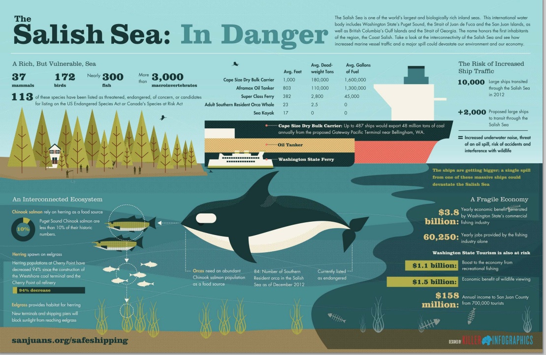
• The greatest risk from oil tanker traffic is a spill which will decimate the marine environment and create havoc for humans (unknown health impacts, job loss from industries like tourism and recreation, agricultural loss, property value decline…); despite the glitzy ads to the contrary form Trans Mountain.
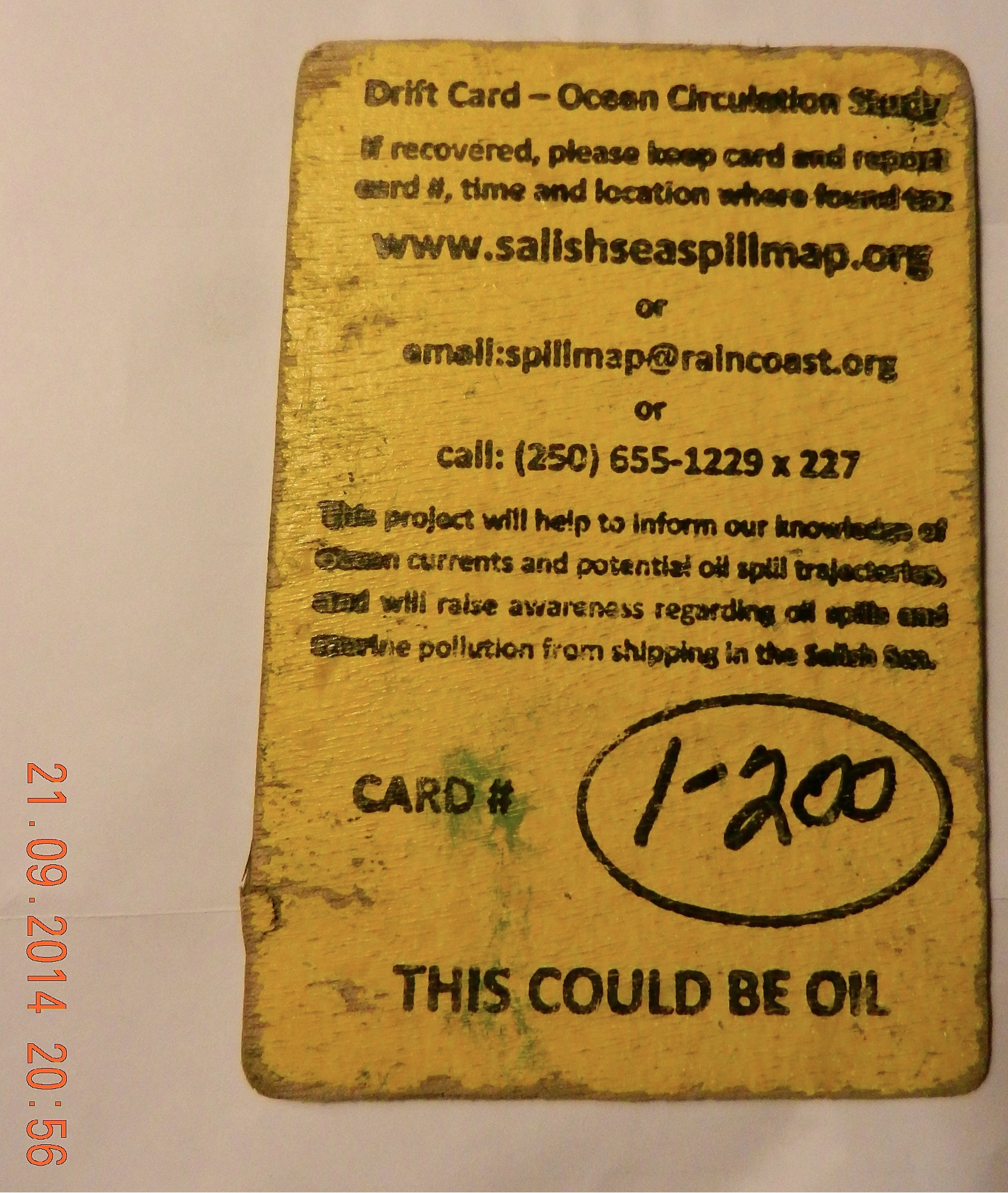
• We all held our breath while the Russian ship Simushir, carrying 400 tonnes of bunker oil and 50 tonnes of diesel fuel, drifted off the coast of Haida Gwai. Veteran West Coast Mariner, Brian Falconer, maintains the coast guard underestimated the risk: “…they’re setting up a false sense that we can actually do something about an oil spill. The reality is we won’t be able to do anything” (TC, Oct 22, p A5). The tankers carrying bitumen will be far larger than Simushir. (As I write, a 134′ barge carrying 3,600 l of diesel fuel is adrift in the Beaufort Sea …)
Dilbit is already being shipped past our shores with ‘temporary’ permits.
• Christy Clark says she has five conditions before approving pipeline expansion (http://www.newsroom.gov.bc.ca/2012/07/statement-by-premier-christy-clark.html). Andrew Weaver says – implement those conditions now.
• Andrew also noted that, on Wednesday of this week, Christy Clark’s gov’t dismantled large portions of the climate legislation enacted by Gordon Campbell’s gov’t; an action with huge implications which went unnoticed because of events on Parliament Hill.

MUNICIPAL MATTERS

• Good to see the following candidates in attendance at the Metchosin Town Hall: Moralea Milne (incumbent Councillor, who initiated the first motion opposing increased tanker traffic in 2012); Andy MacKinnon, Anne Richmond. (Apologies received from: Chris Moehr, Kyara Kahakawila; Bob Gramigma was at a Council related meeting).

• Municipal candidates responses to the Dogwood survey are now posted: http://www.localvote2014.ca/

• Municipal mayors/councillors/candidates may say, “It’s not my jurisdiction,” but Kai Nagata pointed out
Municipal Mayors and Councils have a great deal of influence – if they choose to use it.

We, the voters, must support those brave enough to take a stand.

(e.g., Andrew Weaver is pushing for a complete ban on heavy oil tankers in BC waters – municipal councils could get behind him on this initiative)
• Municipal Councils – backed by the citizens they represent – are perhaps the “last bastion” to stop the massive giveaway of public resources to large corporations.
RAVEN
• Donations to Raven – a Trust for 1st Nations Legal Defense, totalled $170;  thanks to Allison’s generous initiative. (And we had not even thought to collect donations, as evidenced by our blue recycling bin ‘collection plate’!)

THANK YOU VOLUNTEERS!

Horned Grebe, ( Podiceps auritus)

hornedgrebe4

Horned grebe Podiceps auritus off Taylor Beach, Oct 10, 2014


These photos were taken by G. Fletcher off the shore of Taylor Beach on Oct 10/14 Unfortunately I didn’t have a telephoto along!

The tentative identification is the Horned grebe.

The following is quoted from From the Species at Risk Registry
“Horned Grebe: Scientific Name: Podiceps auritus
Taxonomy Group: Birds
Range: Yukon, Northwest Territories, Nunavut, British Columbia, Alberta, Saskatchewan, Manitoba, Ontario
Last COSEWIC Assessment: April 2009
Last COSEWIC Designation: Special Concern
SARA Status: No schedule, No Status

Threats NOte Bolded sentence:

The factors limiting Horned Grebe populations in Canada are not known, but several possible causes for the decline have been identified, including degradation of wetland breeding habitat and droughts. Permanent loss of wetlands to agriculture and development threaten Horned Grebe populations. Temporary loss of wetlands during droughts can also negatively impact Horned Grebe populations, and the length and frequency of droughts in the Prairies is expected to increase in the future, due to climate change. Eutrophication, i.e., the alteration of an aquatic environment linked to a significant input of nutrients that increases the production of algae and aquatic plants, as well as degradation of nesting sites from the accumulation of fertilizers used in agriculture or other contaminants could also threaten populations. In the Prairies, the major expansion of some predators, including Common Ravens, Black-billed Magpies and racoons, could be a factor causing a decline in the Western population. Type E botulism has been reported in the Great Lakes since the late 1990s and may be an important source of mortality for both resident and migrating waterbirds. Oil spills on their wintering grounds can also threaten Horned Grebe populations. At sea, these birds are particularly vulnerable, since they spend most of their time on the water. Competition with Pied-billed Grebes for breeding habitat could be a limiting factor for the Western population. Similarly, Red-necked Grebes may exclude Horned Grebes from nesting on some ponds. Finally, Horned Grebes become entangled and drown in nets in some commercial fishing areas. It is estimated that 3000 grebes and loons are netted annually by fishers on the southern part of Lake Winnipegosis in Manitoba. On the Great Lakes, birds are killed annually in fishing nets during both spring and fall migrations.


Drift Cards for Oil Spill Study Recovered on Taylor Beach

A number of NGOs concerned with the threat of increasing oil tanker traffic through the Georgia Strait and The Strait of Juan de Fuca have released drift cards in the Drift Card Ocean Circulation Study. The aim is to provide accurate models for predicting the trajectory of an oil spill in the Fraser River, Puget Sound or the Strait of Juan de Fuca. This is especially important to know now since the Kinder Morgan Trans Mountain Pipeline Expansion Project looms on our doorstep.

There is a map with locations of recovered cards.  http://www.salishseaspillmap.org/

The pink  card released by The Friends of San Juans had not spent very much time in the water but  it is apparent that the yellow card spent a great deal more time in the ocean as it is considerably more warn and scratched than the first pink card.

There was a brisk wind blowing from the East today, The first time I noticed eel-grass close to the water in the strand line, and this card was recovered from there. at 48°22’10.1″N 123°31’48.2″W.

On November 9, 2014 : The following  card was on Taylor beach, at high tide level, driven up by the storms with surge from the East in the past week. This card is fairly worn, the messsage was very hard to read, indicating it has been floating around for some time.

raincoast-logo-2014

Andy of Raincoast Conservation Foundation provided the following feedback on the yellow card I found today:”That’s a very cool find! It is from our drops last October, from the mouth of the Fraser River. These cards all moved south initially, and out the Juan de Fuca and up the west side of Vancouver Island. The furthest recovery from that drop location is on BC’s central coast.”

If you find a Drift Card report it as soon as possible with information about date,and time and location of recovery. Directions are included on the card.

This link provides information on the risk of an oil spill on our shores:  https://metchosinmarine.ca/gf/?cat=94


Shiner Perch, Cymatogaster aggregata on the beach

This Shiner Perch, Cymatogaster aggregata was at the water’s edge on Taylor Beach this morning. Cause of death is unknown. They are often found along our coast in shallow waters, and eel-grass communities, and serve as important forage fish, especially as juveniles.

2014=aug-perch1
Classification from Species 2000 & ITIS Catalogue of Life: April 2013
Animalia
Chordata
Actinopterygii
Perciformes
Embiotocidae
Cymatogaster
Cymatogaster aggregata Gibbons, 1854

Supermoon over Taylor Beach and Parry Bay

A perigee moon or “supermoon” tonight over Taylor Beach.

“A “supermoon” is the coincidence of a full moon or a new moon with the closest approach the Moon makes to the Earth on its elliptical orbit, resulting in the largest apparent size of the lunar disk as seen from Earth. The technical name is the perigeesyzygy of the Earth-Moon-Sun system.” ref .Wikipedia.

moonstrip

Supermoon images over Partry Bay taken by Garry Fletcher — Nikon coolpix S9100

suoermoon2014-08-10 20.51.06supermoon2014-08-10 20.31.41

Ammodytes personatus -Pacific Sand Lance spawning at Taylor Beach

gf-sandlance-july1320154

Sand lance and ruler in centimetres

birdsonsandbar2

Sandbar at the North end of Taylor Beach

This morning with the extreme low tide, (tonight is the full moon)  the small sandbar off the north end of Taylor beach was exposed for a few hours. As the tide came back in, a crow and a glaucous winged-gull were patrolling the area and picking up sandlance as they emerged from the sand, flipped around a few times and then died.  In 15 minutes walking  back and forth along the 40 metre stretch of the sandbar, I picked up 15 of the dead sandlance, forage fish. Several that were still active were returned to the water where they died within a few minutes.  Perhaps this a solution–  having  direct predation as soon as they emerge from their sand burrows in order to prevent  fouling of the beach..

Species recognized by IRMNG:

Kingdom: Animalia +
Phylum: Chordata
Class : Actinopterygii
Order: Perciformes
Family: Ammodytidae
Genus: Ammodytes Linnaeus, 1758
Species: personatus

2014 Metchosin Bioblitz: Gooch Creek species

A large group of interested Metchosinites took a tour through the Gooch Creek estuary and shorefront as part of the Bioblitz which this year focused on Fresh water and estuarine habitats.

Below is the list of some of the findings:

iron bacteria Bacteria Bacteria gooch creek upland ID: Garry Fletcher
Tuber gibosum oregon white truffle fungus Fungus gooch creek upland ID: Ben Hircock
Gerris remigis water strider invertebrate insect gooch creek estuary ID: Garry Fletcher
Tipula spp. crane fly invertebrate insect gooch creek estuary ID: Garry Fletcher
? unidentified water
mite species
Invertebrate arthropod Gooch Creek Pond ID: Rick Nordin
Planaria sp flatworm Invertebrate Platyhelminthes Gooch Creek Pond ID: Rick Nordin
Physella gyrina snail Invertebrate mollusca Gooch Creek Pond ID: Rick Nordin
Planaria sp flatworm Invertebrate Platyhelminthes Gooch Creek Pond ID: Rick Nordin
Physella gyrina snail Invertebrate mollusca Gooch Creek Pond ID: Rick Nordin
Philaneus spumarius spittle bug Invertebrate Insect gooch creek estuary ID: Garry Fletcher
Tipula spp. crane fly invertebrate insect gooch creek estuary ID: Garry Fletcher
Oscillatoria (2 species) diatom Phytoplankton: diatom Gooch Creek Pond ID: Rick Nordin
Synedra sp diatom Phytoplankton: diatom Gooch Creek Pond ID: Rick Nordin
Cyclotella sp diatom Phytoplankton: diatom Gooch Creek Pond ID: Rick Nordin
Sphaerozosma sp diatom Phytoplankton: diatom Gooch Creek Pond ID: Rick Nordin
Hydrosera diatom -spectacular and uncommon Phytoplankton: diatom Gooch Creek Pond ID: Rick Nordin
Kephyrion diatom Phytoplankton: diatom Gooch Creek Pond ID: Rick Nordin
Achillea millefolium yarrow Vascular plant Forb adjacent toTaylor beach ID: Garry Fletcher
Ambrosia chamissonis Silver burr ragweed Vascular plant Forb adjacent to Taylor beach ID: Garry Fletcher
Cakille edentula American Sea Rocket Vascular plant forb adjacent to Taylor beach ID: Garry Fletcher
Chenopodium album red goosefoot Vascular plant Forb gooch creek estuary ID: Garry Fletcher
? Colomia heterophylla vari-leaved collomia Vascular plant Forb gooch creek estuary ID: Garry Fletcher
Epipactis helleborine. orchid Vascular plant forb gooch creek estuary ID: Garry Fletcher
Equisetum arvense field horsetail Vascular plant forb gooch creek estuary ID: Garry Fletcher
Galium aparine cleavers Vascular plant Forb adjacent to Taylor beach ID: Garry Fletcher
Lathyrus littoralis Beach Pea Vascular plant Forb adjacent toTaylor beach ID: Garry Fletcher
Lemna minor Common duckweed Vascular plant forb gooch creek estuary ID: Garry Fletcher
Lysichiton americanum skunk cabbage Vascular plant forb gooch creek estuary ID: Garry Fletcher
Maianthemum dilatatum false lily of the valley Vascular plant Forb gooch creek estuary ID: Garry Fletcher
Oenanthe sarmentosa Pacific water parsley Vascular plant Forb gooch creek upland ID: Garry Fletcher
Potentilla anserina silverweed Vascular plant Forb gooch creek estuary ID: Garry Fletcher
Ranunculus occidentalis Western buttercup Vascular plant Forb gooch creek estuary ID: Garry Fletcher
? Ranunculus repens Creepinng buttercup Vascular plant Forb gooch creek estuary ID: Garry Fletcher
Rumex cripsus curled dock Vascular plant Forb gooch creek estuary ID: Garry Fletcher
Rumex obtusifolius broad leafed dock Vascular plant Forb gooch creek estuary ID: Garry Fletcher
Sanicle crassicaulis Pacific sanicle Vascular plant Forb gooch creek upland ID: Garry Fletcher
Sonchus oleraceus Sow thistle Vascular plant Forb gooch creek estuary ID: Garry Fletcher
Stachys cooleyae Cooley’s hedge nettle Vascular plant Forb gooch creek estuary ID: Garry Fletcher
Veronica beccabunga American brooklime Vascular plant Forb gooch creek estuary ID: Garry Fletcher
Holcus lanatus Velvet grass Vascular plant grass gooch creek estuary ID: Garry Fletcher
Festuca arundenacea tall fescue Vascular plant grass gooch creek estuary ID: A.Ceska
Distichlis spicata seasaide saltgrass Vascular plant grass gooch creek estuary ID: Garry Fletcher
Triglochin maritima Sea arrowgrass Vascular plant grass gooch creek estuary ID: Garry Fletcher
Lemus mollis tall beachgrass Vascular plant grass adjacent toTaylor beach ID: Garry Fletcher
Typha latifolia cattail Vascular plant grass gooch creek estuary ID: Garry Fletcher
Phragmites australis (Cav.)
Trin. ex Steud. subsp. americanus
marsh reed grass Vascular plant grass gooch creek estuary ID: Garry Fletcher, by DNA Sampling-FLNRO
Scirpus microcarpus small-flowered bulrush Vascular plant Rush gooch creek estuary ID: A.Ceska
Scirpus validus hard-stemmed bulrush Vascular plant Rush gooch creek estuary ID: A.Ceska
Juncus balticus Artic rush Vascular plant Rush gooch creek estuary ID: A.Ceska
Juncus effusus common rush Vascular plant Rush gooch creek estuary ID: A.Ceska
Carex obnupta slough sedge Vascular plant sedge gooch creek estuary ID: A.Ceska
Carex sitchensis Sitka sedge Vascular plant sedge gooch creek estuary ID: A.Ceska
Cystis scoparius Scotch broom Vascular plant shrub gooch creek estuary ID: Garry Fletcher
Rosa nutkana Nootka rose Vascular plant shrub gooch creek estuary ID: Garry Fletcher
Mahonia aquifolium oregon grape Vascular plant shrub gooch creek upland ID: Garry Fletcher
Physocarpus capilatus Pacific ninebark Vascular plant shrub gooch creek estuary ID: Garry Fletcher
Oemleria cerasiformis Indian plum Vascular plant Shrub gooch creek estuary ID: Garry Fletcher
Rubus spectabilis salmon berry Vascular plant Shrub gooch creek estuary ID: Garry Fletcher
Symphoricarpos albus snowberry Vascular plant Shrub gooch creek estuary ID: Garry Fletcher
Ulex europaeus gorse Vascular plant Shrub adjacent to Taylor beach ID: Garry Fletcher
Viburnum edule highbush cranberry Vascular plant Shrub gooch creek estuary ID: Garry Fletcher
Cornus sericea red osier dogwood Vascular plant Shrub gooch creek estuary ID: Garry Fletcher
Populus balsamifera Black Poplar Vascular plant tree gooch creek estuary ID: Garry Fletcher
Acer macrophyllum big leaf maple Vascular plant Tree gooch creek upland ID: Garry Fletcher
Alnus rubra red alder Vascular plant Tree gooch creek upland ID: Garry Fletcher
Arbutus menziesii arbutus Vascular plant Tree gooch creek upland ID: Garry Fletcher
Malus fusca Pacific crabapple Vascular plant Tree gooch creek upland ID: Garry Fletcher
Prunus emarginata Bitter cherry Vascular plant Tree gooch creek upland ID: Garry Fletcher
Pseudotsuga menziesii Douglas fir Vascular plant Tree gooch creek upland ID: Garry Fletcher
Salix sitchensis Sitka willow Vascular plant Tree gooch creek estuary ID: Garry Fletcher
Abies grandis grand fir Vascular plant tree adjacent toTaylor beach ID: Garry Fletcher
Taxus brevifolia Pacific western yew Vascular plant Tree gooch creek estuary ID: Garry Fletcher
Anas platyrhynchos mallard Vertebrate Bird gooch creek estuary ID: Garry Fletcher
Agelaius phoeniceus red-winged blackbird Vertebrate Bird gooch creek estuary ID: Garry Fletcher
Geothlypis trichas yellowthroat Vertebrate Bird gooch creek estuary ID: Rick Shortinghouse
Falco columbarius merlin Vertebrate Bird gooch creek upland ID: Rick Shortinghouse
Callipepla californica California quail Vertebrate Bird gooch creek upland ID: Garry Fletcher
Gasterosteus aculeatus, 3-spined Stickleback Vertebrate Fish gooch creek estuary ID: Moralea Milne
Bioblitz Species in the Gooch Creek Area, May 2014,
submitted by Garry Fletcheramerican_brooklime_flowermany grass species and mosses were groups that were not identified< 

Eelgrass /macroalgae Habitat Survey Guidelines: Washington State

Below is a publication which may be useful in providing ideas for a similar program in Metchosin:

Eelgrass/Macroalgae Habitat Interim Survey Guidelines

This publication was downloaded from http://wdfw.wa.gov/publications/00714/

Introduction

Under the Washington Administrative Code (WAC), eelgrass and macroalgae are defined as saltwater habitats of special concern (WACs 220-110-250 (3)(a, b)). In administering the Hydraulic Project Approval (HPA) process, the Washington Department of Fish and Wildlife (WDFW) requires proponents for projects to: 1) avoid impacting eelgrass and macroalgae, 2) minimize unavoidable impacts, and 3) mitigate for any impacts. Mitigation for the loss of eelgrass typically entails providing eelgrass enhancement away from the project footprint. Because establishment of new eelgrass for mitigation is often unsuccessful, project proponents need to address this uncertainty by increasing the scope of their mitigation effort, such as planting an area larger than the project impact footprint. For macroalgae mitigation measures, the WDFW Area Habitat Biologist (AHB) shall be consulted.

In known or suspected eelgrass areas, proponents shall survey to delineate the spatial extent of eelgrass and macroalgae presence in the project area. If the project cannot be moved or redesigned to avoid direct eelgrass and macroalgae impacts, surveys are required for quantifying potential impacts. Surveys shall be conducted by divers/biologists who are qualified to identify the predominant eelgrass and macroalgae species in the project area. Deviations from the survey guidelines shall be approved by the AHB prior to conducting eelgrass or macroalgae surveys. Survey results and interpretation will be subject to WDFW approval.

Preliminary Surveys

Preliminary surveys are conducted to:

  1. 1)  determine if eelgrass or macroalgae are present at the proposed project site,
  2. 2)  evaluate if the project can be located and constructed to avoid impacting eelgrass or macroalgae, and
  3. 3)  establish a location for the project that will minimize impacts when avoidance is not possible. Eelgrass/Macroalgae Habitat Interim Survey Guidelines 1 of 6 (Rev. 06/16/2008)

Preliminary surveys shall provide:

A project site map indicating all survey transects and showing the qualitative distribution of eelgrass and macroalgae (boundaries of each patch), as well as substrate characterization along each transect. The map should also indicate approximate depth contours and the approximate location of the proposed project footprint (e.g., the dimensions of the pier, ramp and float).

Protocol Guidance

  1. Transects should be referenced to a permanent physical feature at the project site in such a way that transects can be precisely relocated in the future.
  2. Transect length and location should be determined by project and site specifics, and should include the landward margin of the eelgrass or macroalgae habitat, if present. Transect coverage should extend at least 25 feet waterward of the project footprint, and, if possible, to the outer margin of the eelgrass or macroalgae bed.
  3. To document the potential for eelgrass or macroalgae impacts from a project, at least one transect should be aligned along the proposed centerline of the project footprint. Additional transects shall be conducted on either side of the project footprint at 10 and 25 feet from the outer edges of the proposed structure. The inner and outer edges of each eelgrass or macroalgae patch shall be documented along each transect and noted on the site map.
  4. Depth contours should be established relative to mean lower low water equal to 0.0 feet elevation (MLLW=0.0 ft.). Tidal reference and correction should be noted on the site map.
  5. Survey documentation must include the date and time of the survey, name of the surveyor and their affiliation, turbidity/visibility measurements, presence of invertebrate and vertebrate species, and anecdotal observations pertinent to habitat characterization of the project site (e.g., presence of rocky outcroppings, debris, etc.).
  6. Conducting surveys between June 1 and October 1 is strongly preferred because the full extent of eelgrass and macroalgae distribution can be more accurately mapped. However, preliminary surveys may be conducted at any time during the year.

To meet the need to minimize eelgrass and macroalgae impacts, and the requirement to document the centerline of the project footprint, some flexibility at the time of the survey may be necessary. A preferred method is to establish a transect parallel to the shoreline, along the midpoint of the eelgrass or macroalgae bed, to locate any open patches where a

Eelgrass/Macroalgae Habitat Interim Survey Guidelines 2 of 6 (Rev. 06/16/2008)

new centerline for the project could be placed. Typically, an open area sufficient to accommodate a ten-foot buffer around the project footprint will be necessary.

If the preliminary survey shows that the project can be located and built without impacting eelgrass or macroalgae, the preliminary survey will meet the needs for mapping the project area. However, if the project footprint potentially impacts existing eelgrass or macroalgae beds, advanced surveys to quantify the extent of impact and document mitigation success, will be required.

Advanced Surveys

Advanced surveys shall occur between June 1 and October 1 and are conducted to:

  1. quantify the impact from the project to eelgrass and macroalgae, and
  2. quantify the performance of mitigation actions.

Quantifying Impacts

The standard protocols described below are designed to give accurate estimates of project impacts. Eelgrass density is determined by sampling with quadrats along transects. Two methods are typically used to determine project impacts and required mitigation. Project impacts are calculated as the total area of eelgrass affected by the project, as determined by the AHB. Alternatively, project impacts can be monitored in the project area to determine eelgrass or macroalgae loss and required mitigation. Sampling results are used to calculate the size of the mitigation project required to compensate for impacts that cannot be avoided.

As noted above, a project proponent may choose to monitor post-project impacts directly. The size of the required mitigation obligation may be reduced by this approach (e.g., in cases where post project impacts were less than anticipated). However, this approach will require additional monitoring of survey transects for a number of years to evaluate potential changes to eelgrass densities in the project area and within a reference site. This approach involves potentially higher mitigation ratios due to the delay in mitigation project construction (e.g., adjusting for temporal loss of function).

Alternative sampling designs are allowed, when agreed to in consultation with the AHB. This may be particularly appropriate when the potential impacts have been avoided to the maximum extent possible, and only a few small patches of eelgrass remain within or near the project footprint. In such a case, a full census of impacted eelgrass may be the most cost-effective option (e.g., counting all eelgrass shoots in the impact area). Alternatively, a stratified sampling of the existing patches may be a better choice (e.g., taking density estimates in the eelgrass patches only).

Eelgrass/Macroalgae Habitat Interim Survey Guidelines 3 of 6 (Rev. 06/16/2008)

Statistical Considerations

1. Measuring mitigation success (or direct impacts of a project) requires comparing eelgrass densities at a mitigation (or impact) site versus a reference site. These comparisons must be statistically rigorous, and include the following statistical considerations:

  • Low probability of a Type I error – concluding there is loss of eelgrass when, in fact, there is not. This issue is addressed by selecting a small value for α in statistical analyses, usually 0.10.
  • Low probability of a Type II error – failing to detect a loss of eelgrass when, in fact, there is one. Selecting a small value for β (applying high statistical power, (1-β)) ensures this. Power set at 0.90 provides low probability of a Type II error.
  • Effect threshold – the difference in mean eelgrass density between sites. The WDFW has established monitoring standards for these surveys: a) α = 0.10, b) power (1 – β) = 0.90, and c) a difference of mean eelgrass density of 20%. Surveys using an alternative design must meet or exceed these standards. Standard Protocols for Quantifying Impact
  1. For a linear project, a single transect should be aligned along the centerline of the footprint.
  2. A minimum of 30 samples must be taken within the area of eelgrass or macroalgae. Samples consist of eelgrass shoot counts within a (minimum) 1⁄4 m2 area quadrat. Sampling stations may be placed randomly along the transect, or for simplicity, evenly spaced along the same line starting at a random point (i.e., stratified random). Convert raw sample counts to shoot densities per square meter (#/m2).
  3. Using the sample data, calculate mean eelgrass density ( ̄x project) in the impact area, as well as sample variance (s2).

Assessing Mitigation Performance

Eelgrass density often varies substantially among locations and through time, making it difficult to measure mitigation success. To address this uncertainty, WDFW requires the use of a reference site to account for regional differences in eelgrass density and temporal variability. Use of a reference site can also improve monitoring efficiency, supporting rigorous results with fewer samples. The reference site should be chosen to match the characteristics of the mitigation area.

Eelgrass/Macroalgae Habitat Interim Survey Guidelines 4 of 6 (Rev. 06/16/2008)

Quantifying Mitigation Performance

Reference Site Characterization

1. Choose a reference site near the proposed mitigation site. The reference site should be similar to the mitigation site in depth profile, substrate, turbidity, and disturbance regimes.

2. Within the reference site, take a minimum of 30 samples, either randomly or stratified randomly. Samples involve counting eelgrass shoots within a (minimum) 1⁄4 m2 area quadrat. Samples can be larger than 1⁄4 m squares, but all samples need to reference the area from which they were taken so that the data can be converted to shoot densities (#/m2).

3. Calculate the mean density of eelgrass at the reference site ( ̄x reference) as well as sample variance (s2).

Mitigation Area Extent

The objective of eelgrass mitigation is to replace lost shoots and an area equivalent to the impacted area. If the mean density of eelgrass is lower at the reference site than within the impact area, the size of the mitigation project needs to be enlarged such that the reference site has the same total number of shoots as the impact site. For example, if the project impacts an area of 10 m2, with a mean eelgrass density of 20 shoots/m2, while the reference area has a mean shoot density of 10 shoots/m2, the mitigation area would need to be at least 20 m2 (to achieve a 1:1 mitigation ratio). However, if the reference site has greater density than the impact area, no area adjustment to the mitigation site would be necessary to address density differences. In addition, other factors can influence mitigation ratios and thus the required size of the mitigation area.

Mitigation Sampling and Performance

Mitigation monitoring consists of sampling both the reference site and the mitigation area at three and five-years following the completion of the mitigation project. Sampling one year following project completion is recommended to detect early failures at the mitigation site, but the need for this can be determined on a site-specific basis. Enough samples must be taken at the two sites to be able to detect significant differences in eelgrass density at the mitigation site versus the reference site using the statistical considerations noted above. A Microsoft Excel spreadsheet (Sample_Size_Calculator.xls) programmed to calculate the required sample size is provided by WDFW. Specific directions for entering data are included on the spreadsheet. The sample size calculator uses the following formula, modified from Zar (1999).

N = [2*s2reference/( ̄x reference – x ̄ mitigation)2] * (t α(1), v + t β(1), v)2

Eelgrass/Macroalgae Habitat Interim Survey Guidelines 5 of 6 (Rev. 06/16/2008)

Where: N = required sample size in each site (i.e., mitigation and reference), s2reference = sample variance from the reference site,
x ̄ = sample mean
t = percentage values from Student’s t-distribution

v = degrees of freedom

If the required number of samples is prohibitively expensive, due to inherent variability of eelgrass density, the statistical power of the monitoring may be lowered. This will entail a larger mitigation project to account for the increased statistical uncertainty.

Statistical Testing

At year three and five post construction, the proponent is required to re-sample and compare (statistically) eelgrass densities at the reference and mitigation site (using the prescribed number of plots defined in the equation above). We suggest using a two- sample, one-tailed t-test for comparison of eelgrass mean densities from mitigation versus reference areas. The statistical null hypothesis in this case is – H0: eelgrass density at the mitigation site eelgrass density at the reference site.

The year-three sample is designed to detect potential early failures in eelgrass growth at the mitigation site, relative to the reference site, that may suggest the need for additional actions at the mitigation site (e.g., additional transplants). Final mitigation success or failure will be based on year-five survey results and statistical testing (H0: eelgrass density at the mitigation site density at reference site, and total shoot abundance criteria has been met). Failure to meet prescribed eelgrass density (i.e., rejecting the null hypothesis) and shoot abundance will require implementation of contingency actions identified in the mitigation plan.

Eelgrass/Macroalgae Habitat Interim Survey Guidelines 6 of 6 (Rev. 06/16/2008)