This image is from the website of the Friends of San Juans, http://www.sanjuans.org/
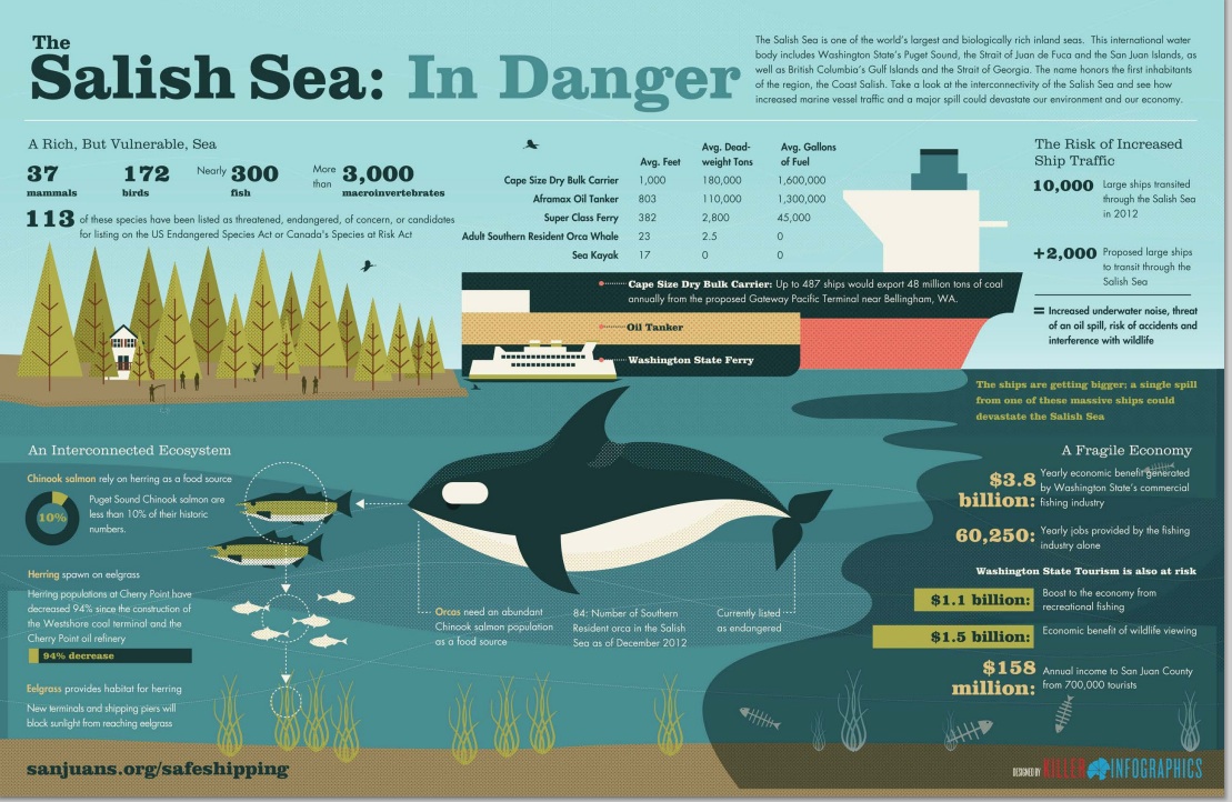

This image is from the website of the Friends of San Juans, http://www.sanjuans.org/

A number of NGOs concerned with the threat of increasing oil tanker traffic through the Georgia Strait and The Strait of Juan de Fuca have released drift cards in the Drift Card Ocean Circulation Study. The aim is to provide accurate models for predicting the trajectory of an oil spill in the Fraser River, Puget Sound or the Strait of Juan de Fuca. This is especially important to know now since the Kinder Morgan Trans Mountain Pipeline Expansion Project looms on our doorstep.
There is a map with locations of recovered cards. http://www.salishseaspillmap.org/
The pink card released by The Friends of San Juans had not spent very much time in the water but it is apparent that the yellow card spent a great deal more time in the ocean as it is considerably more warn and scratched than the first pink card.
There was a brisk wind blowing from the East today, The first time I noticed eel-grass close to the water in the strand line, and this card was recovered from there. at 48°22’10.1″N 123°31’48.2″W.
On November 9, 2014 : The following card was on Taylor beach, at high tide level, driven up by the storms with surge from the East in the past week. This card is fairly worn, the messsage was very hard to read, indicating it has been floating around for some time.
Andy of Raincoast Conservation Foundation provided the following feedback on the yellow card I found today:”That’s a very cool find! It is from our drops last October, from the mouth of the Fraser River. These cards all moved south initially, and out the Juan de Fuca and up the west side of Vancouver Island. The furthest recovery from that drop location is on BC’s central coast.”
If you find a Drift Card report it as soon as possible with information about date,and time and location of recovery. Directions are included on the card.
This link provides information on the risk of an oil spill on our shores: https://metchosinmarine.ca/gf/?cat=94
A perigee moon or “supermoon” tonight over Taylor Beach.
“A “supermoon” is the coincidence of a full moon or a new moon with the closest approach the Moon makes to the Earth on its elliptical orbit, resulting in the largest apparent size of the lunar disk as seen from Earth. The technical name is the perigee–syzygy of the Earth-Moon-Sun system.” ref .Wikipedia.
The Brochure “Sharing our Shorelines ” was produced in 2013 by members of the Metchosin Environmental Advisory Committee. It reflected the values outlined in the Shoreline Report published in the fall of 2013.
This document is available also on the District of Metchosin website:
Below is a publication which may be useful in providing ideas for a similar program in Metchosin:
Eelgrass/Macroalgae Habitat Interim Survey Guidelines
This publication was downloaded from http://wdfw.wa.gov/publications/00714/
Introduction
Under the Washington Administrative Code (WAC), eelgrass and macroalgae are defined as saltwater habitats of special concern (WACs 220-110-250 (3)(a, b)). In administering the Hydraulic Project Approval (HPA) process, the Washington Department of Fish and Wildlife (WDFW) requires proponents for projects to: 1) avoid impacting eelgrass and macroalgae, 2) minimize unavoidable impacts, and 3) mitigate for any impacts. Mitigation for the loss of eelgrass typically entails providing eelgrass enhancement away from the project footprint. Because establishment of new eelgrass for mitigation is often unsuccessful, project proponents need to address this uncertainty by increasing the scope of their mitigation effort, such as planting an area larger than the project impact footprint. For macroalgae mitigation measures, the WDFW Area Habitat Biologist (AHB) shall be consulted.
In known or suspected eelgrass areas, proponents shall survey to delineate the spatial extent of eelgrass and macroalgae presence in the project area. If the project cannot be moved or redesigned to avoid direct eelgrass and macroalgae impacts, surveys are required for quantifying potential impacts. Surveys shall be conducted by divers/biologists who are qualified to identify the predominant eelgrass and macroalgae species in the project area. Deviations from the survey guidelines shall be approved by the AHB prior to conducting eelgrass or macroalgae surveys. Survey results and interpretation will be subject to WDFW approval.
Preliminary Surveys
Preliminary surveys are conducted to:
Preliminary surveys shall provide:
• A project site map indicating all survey transects and showing the qualitative distribution of eelgrass and macroalgae (boundaries of each patch), as well as substrate characterization along each transect. The map should also indicate approximate depth contours and the approximate location of the proposed project footprint (e.g., the dimensions of the pier, ramp and float).
Protocol Guidance
To meet the need to minimize eelgrass and macroalgae impacts, and the requirement to document the centerline of the project footprint, some flexibility at the time of the survey may be necessary. A preferred method is to establish a transect parallel to the shoreline, along the midpoint of the eelgrass or macroalgae bed, to locate any open patches where a
Eelgrass/Macroalgae Habitat Interim Survey Guidelines 2 of 6 (Rev. 06/16/2008)
new centerline for the project could be placed. Typically, an open area sufficient to accommodate a ten-foot buffer around the project footprint will be necessary.
If the preliminary survey shows that the project can be located and built without impacting eelgrass or macroalgae, the preliminary survey will meet the needs for mapping the project area. However, if the project footprint potentially impacts existing eelgrass or macroalgae beds, advanced surveys to quantify the extent of impact and document mitigation success, will be required.
Advanced Surveys
Advanced surveys shall occur between June 1 and October 1 and are conducted to:
Quantifying Impacts
The standard protocols described below are designed to give accurate estimates of project impacts. Eelgrass density is determined by sampling with quadrats along transects. Two methods are typically used to determine project impacts and required mitigation. Project impacts are calculated as the total area of eelgrass affected by the project, as determined by the AHB. Alternatively, project impacts can be monitored in the project area to determine eelgrass or macroalgae loss and required mitigation. Sampling results are used to calculate the size of the mitigation project required to compensate for impacts that cannot be avoided.
As noted above, a project proponent may choose to monitor post-project impacts directly. The size of the required mitigation obligation may be reduced by this approach (e.g., in cases where post project impacts were less than anticipated). However, this approach will require additional monitoring of survey transects for a number of years to evaluate potential changes to eelgrass densities in the project area and within a reference site. This approach involves potentially higher mitigation ratios due to the delay in mitigation project construction (e.g., adjusting for temporal loss of function).
Alternative sampling designs are allowed, when agreed to in consultation with the AHB. This may be particularly appropriate when the potential impacts have been avoided to the maximum extent possible, and only a few small patches of eelgrass remain within or near the project footprint. In such a case, a full census of impacted eelgrass may be the most cost-effective option (e.g., counting all eelgrass shoots in the impact area). Alternatively, a stratified sampling of the existing patches may be a better choice (e.g., taking density estimates in the eelgrass patches only).
Eelgrass/Macroalgae Habitat Interim Survey Guidelines 3 of 6 (Rev. 06/16/2008)
Statistical Considerations
1. Measuring mitigation success (or direct impacts of a project) requires comparing eelgrass densities at a mitigation (or impact) site versus a reference site. These comparisons must be statistically rigorous, and include the following statistical considerations:
Assessing Mitigation Performance
Eelgrass density often varies substantially among locations and through time, making it difficult to measure mitigation success. To address this uncertainty, WDFW requires the use of a reference site to account for regional differences in eelgrass density and temporal variability. Use of a reference site can also improve monitoring efficiency, supporting rigorous results with fewer samples. The reference site should be chosen to match the characteristics of the mitigation area.
Eelgrass/Macroalgae Habitat Interim Survey Guidelines 4 of 6 (Rev. 06/16/2008)
Quantifying Mitigation Performance
Reference Site Characterization
1. Choose a reference site near the proposed mitigation site. The reference site should be similar to the mitigation site in depth profile, substrate, turbidity, and disturbance regimes.
2. Within the reference site, take a minimum of 30 samples, either randomly or stratified randomly. Samples involve counting eelgrass shoots within a (minimum) 1⁄4 m2 area quadrat. Samples can be larger than 1⁄4 m squares, but all samples need to reference the area from which they were taken so that the data can be converted to shoot densities (#/m2).
3. Calculate the mean density of eelgrass at the reference site ( ̄x reference) as well as sample variance (s2).
Mitigation Area Extent
The objective of eelgrass mitigation is to replace lost shoots and an area equivalent to the impacted area. If the mean density of eelgrass is lower at the reference site than within the impact area, the size of the mitigation project needs to be enlarged such that the reference site has the same total number of shoots as the impact site. For example, if the project impacts an area of 10 m2, with a mean eelgrass density of 20 shoots/m2, while the reference area has a mean shoot density of 10 shoots/m2, the mitigation area would need to be at least 20 m2 (to achieve a 1:1 mitigation ratio). However, if the reference site has greater density than the impact area, no area adjustment to the mitigation site would be necessary to address density differences. In addition, other factors can influence mitigation ratios and thus the required size of the mitigation area.
Mitigation Sampling and Performance
Mitigation monitoring consists of sampling both the reference site and the mitigation area at three and five-years following the completion of the mitigation project. Sampling one year following project completion is recommended to detect early failures at the mitigation site, but the need for this can be determined on a site-specific basis. Enough samples must be taken at the two sites to be able to detect significant differences in eelgrass density at the mitigation site versus the reference site using the statistical considerations noted above. A Microsoft Excel spreadsheet (Sample_Size_Calculator.xls) programmed to calculate the required sample size is provided by WDFW. Specific directions for entering data are included on the spreadsheet. The sample size calculator uses the following formula, modified from Zar (1999).
N = [2*s2reference/( ̄x reference – x ̄ mitigation)2] * (t α(1), v + t β(1), v)2
Eelgrass/Macroalgae Habitat Interim Survey Guidelines 5 of 6 (Rev. 06/16/2008)
Where: N = required sample size in each site (i.e., mitigation and reference), s2reference = sample variance from the reference site,
x ̄ = sample mean
t = percentage values from Student’s t-distribution
v = degrees of freedom
If the required number of samples is prohibitively expensive, due to inherent variability of eelgrass density, the statistical power of the monitoring may be lowered. This will entail a larger mitigation project to account for the increased statistical uncertainty.
Statistical Testing
At year three and five post construction, the proponent is required to re-sample and compare (statistically) eelgrass densities at the reference and mitigation site (using the prescribed number of plots defined in the equation above). We suggest using a two- sample, one-tailed t-test for comparison of eelgrass mean densities from mitigation versus reference areas. The statistical null hypothesis in this case is – H0: eelgrass density at the mitigation site ≥ eelgrass density at the reference site.
The year-three sample is designed to detect potential early failures in eelgrass growth at the mitigation site, relative to the reference site, that may suggest the need for additional actions at the mitigation site (e.g., additional transplants). Final mitigation success or failure will be based on year-five survey results and statistical testing (H0: eelgrass density at the mitigation site ≥ density at reference site, and total shoot abundance criteria has been met). Failure to meet prescribed eelgrass density (i.e., rejecting the null hypothesis) and shoot abundance will require implementation of contingency actions identified in the mitigation plan.
Eelgrass/Macroalgae Habitat Interim Survey Guidelines 6 of 6 (Rev. 06/16/2008)
I attended the Salish Sea Ecosystem Conference in Seattle several weeks ago and one of the sessions I attended was delivered by the presenter of the following report.
In Puget Sound there is no hesitation in bsing very specific on what needs to be done about controlling the impact of humans on the shoreline as they have a long history of making a real mess of many kilometers of shoreline.
http://wdfw.wa.gov/
Our coastline in Metchosin is highly exposed to the potential risks from the increase in tanker traffic that will come if the Kinder Morgan/ Trans Mountain Pipeline Expansion s allowed to proceed. (400 Aframax size tankers per year) In order to provide access to the Information requests from the over 400 intervenors which are available on the NEB website, the following link is provided. The Board of the Friends of Ecological Reserves has posted their first set of Information Requests to the National Energy Board and Kinder Morgan as Intervenors in the Trans Mountain Pipeline Expansion Project . Their concerns focus on the Ecological reserves of Southern Vancouver Island such as Race Rocks . See this link with a further link to all intervenors Information requests. 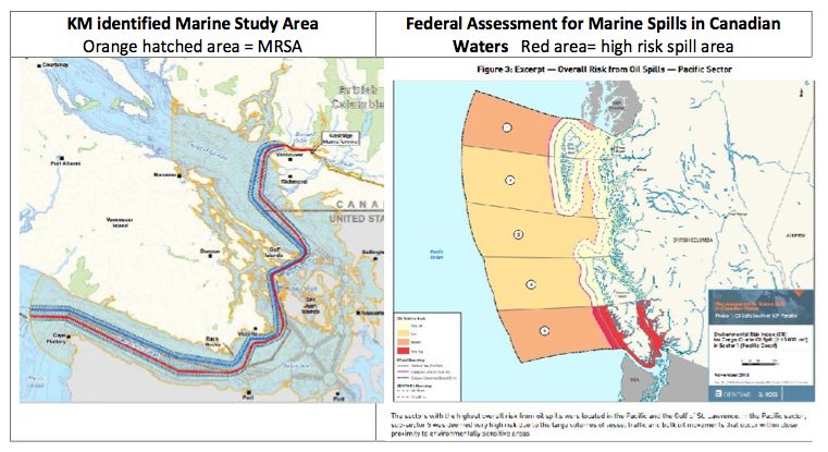
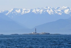
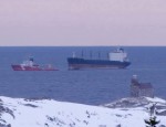 Information provided about oil tankers on websites of energy companies would have us believe that there is almost no risk of ships going ashore. This posting from March 15, 2014 in Newfoundland tells a different story. Lets hope the lighthouse in the foreground isn’t Race Rocks in the future.
http://gcaptain.com/23-
Most of Metchosin’s shorelines could be considered as “Ecologically Sensitive” . The areas identified below however have a particularly high level of sensitivity.
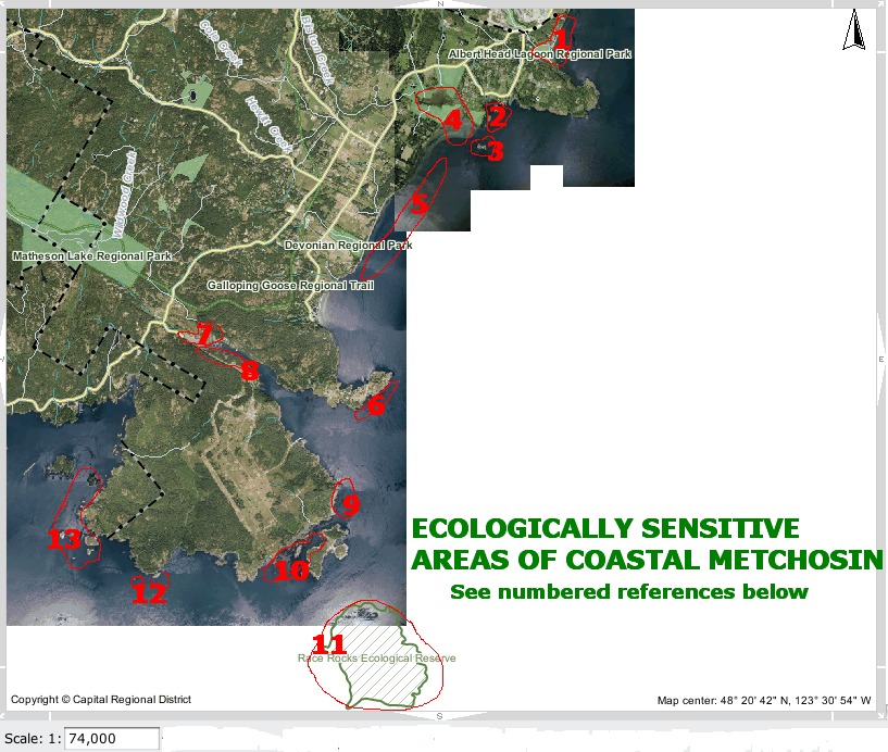
This list does not necessarily include all ecologically sensitive areas. Arguments could be made for the complete coastline being ecologically sensitive.
1. Lagoon with shorebird habitat, sensitive dune vegetation on sand shore.
2. Coastal Islands with harbour seal haulouts
4.Coastal lagoon, migratory and resident seabird habitat.
5. Eel grass beds offshore. Also see:
Sensitive dune vegetation on sand shore.
6. High current invertebrate community
7. Estuary, mudflat habitat for overwintering shorebirds.
8. Cormorant winter roosting colony.
9. Kelp bed for fish spawning and seabird habitat. Great blue herons often feed from the kelp
12. Island ecosystems, swept with strong currents bearing significant invertebrate colonies.
13. Island ecosystems with significant invertebrate and kelp beds.
Return to the anthropogenic impact index
Return to the sector map index
Return to the MetchosinCoastal website Home Page
The Canadian Press
January 29, 2014 01:24 PM
OTTAWA — A government-commissioned risk analysis says the coast of southern British Columbia and the Gulf of St. Lawrence are the Canadian areas most vulnerable marine oil spills and among the most likely for a major spill to occur.
The findings will add to the debate over several pipeline proposals — including two in B.C. that the report says will substantially increase marine risks.
The 256-page study, delivered this month to Transport Canada, looks at the risks associated with marine oil spills south of the 60th parallel under current shipping volumes.
 It identifies the southern tip of Vancouver Island, the Cabot Strait off Newfoundland, the eastern coast of Cape Breton Island and the Gulf of St. Lawrence as the most probable areas for a major oil spill.
But the study also assesses the potential impact of four proposed pipeline projects, including the Northern Gateway Pipeline to Kitimat and Kinder Morgan’s plan to almost triple its Trans Mountain line into Vancouver.
The report says the Kinder Morgan proposal would essentially double oil traffic in an already vulnerable marine environment — with a corresponding increase in spill frequency — while the Northern Gateway marine route would turn what are currently very low, near-shore risks into very high risks.
The study found that reversing Enbridge’s Line 9 to carry Western Canadian crude to refineries in Montreal and Quebec City would actually lower marine spill risks, as it would reduce oil imports through the sensitive Gulf of St. Lawrence.
And the study found that the proposed Energy East Pipeline to St. John, N.B., would likely be a wash, reducing shipping imports but increasing oil exports to leave the overall marine risk about where it is now.
© Copyright Times Colonist
Posts on this website about the risk of oil spills on Metchosin’s shores:
Posts on the Ecological Reserves website about the threat of Oil Spills from Tanker Traffic
Posts on the Race Rocks website about the Risk from Increased Tanker Traffic
See the following posts for further information on Tanker traffic off our shores:
Review of Canada’s Ship-Source Oil-Spill Preparedness and response Regime:
Application to NEB by Board of Friends of Ecological Reserves