The following article has been published in the Metchosin Muse:
Witty’s Beach joins other KBAs in the Victoria area :
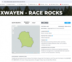
 The other local KBA designation is at Race Rocks Ecological Reserve

The following article has been published in the Metchosin Muse:
Witty’s Beach joins other KBAs in the Victoria area :
 The other local KBA designation is at Race Rocks Ecological Reserve
The full pdf of this report is contained in this pdf:
BC EAO Condition 39 Exisitng Shoreline Conditions Report – May 2023 – for engagement
The purpose of this posting is to reference the part of the report referring to Metchosin’s coastline and to provide comment on it.
===========================================================
 From page 4 of the REPORT:
1 Introduction
As defined by the amendment to Trans Mountain’s BC Environmental Assessment Certificate (EAC) issued by the Province of British Columbia (the Province) on February 24, 2022, Trans Mountain must prepare an Existing Shorelines Condition Report and submit to the Province within 18 months (August 2023) as Condition No. 39.
Polaris Applied Sciences was retained to prepare a report containing shoreline baseline data for shoreline areas closest to spill scenario locations modeled along the marine shipping route and submitted in the Project application. The Province listed the specific scenario locations for the purpose of this study (Figure 1) as:
 Page 25
Strait of Juan de Fuca (south of Race Rocks) (Location G);
Figure 18 shows the Location G – Race Rocks site with the available existing spatial data. Shoreline data are from the Shorezone mapping effort available from the BC Data Catalogue, which show the shore type consisting of rock cliff. Shore-zone Bioband data indicate the presence of barnacles, dark brown kelps, fucus, bull kelp, red algae, surf grass, and Verrucaria. Other data sources indicate offshore kelp beds and multiple seal and sealion haulouts. The Race Rocks Ecological Reserve (RRER) website (https://racerocks.ca/home/) provides more details on ecological resources documented and studied at the site, but not in a spatial format for mapping.
COMMENTS : The exceptionally high Biodiversity of the area and high level of protection since 1980 as a Provincial Ecological Reserve are not reflected at all in the map presented. If one were to look at the Race Rocks Taxonomy presented at https://racerocks.ca/race-rocks-animals-plants/taxonomy-image-gallery/ there may be a better appreciation of the natural capital of this area
===============================================================
Page 26
Comments:
The reference at the Race Rocks website from racerocks.ca which analyzes the Wind speed from observations of the hourly data provided by Environment Canada show a completely different picture . https://racerocks.ca/race-rocks-lightstation-weather-conditions-environment-canada-problems-for-oil-spill-cleanup/
Some facts from the Environment Canada data:
1. In July of 2022 there were 11 days when the wind speed every hour was 28 km/hr or greater. and 69.5% of the hours in the month, clean up equipment could not be deployed due to high velocity wind conditions.
2. In March of 2023, the wind speed was 28 km/hr or greater 37% of the time.
3. In Februarry of 2023 , the wind speed was 28 km/hr or greater 43 % of the time
4. In January of 2023 , the wind speed was 28 km/hr or greater 36% of the time
============================================================
================================================
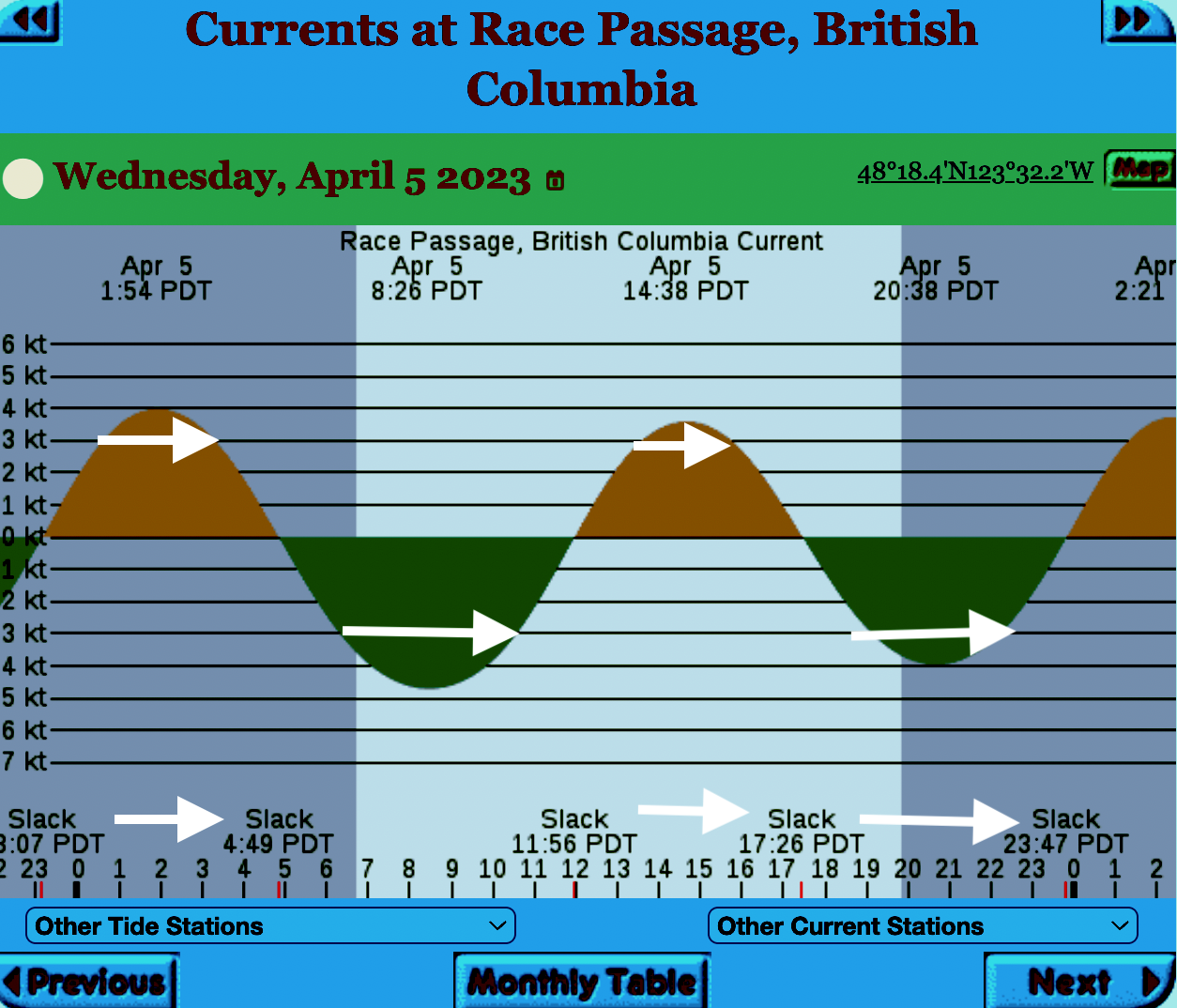
The reality of current speed is that there is a very small window of time during the day that the waters around Race Rocks are not over three knots. In the graph below only in the few hours a day not covered by the white arrows could any boom placement be established. WHen looked at from this perspective, added onto the small windows of time when the wind speed is under 28 km per hour could spilled oil containment even be possible.

=============================================================
 From page 28 of the Polaris report
Field surveys were not conducted at Race Rocks due to the long lead time in acquiring a “research” permit from BC Parks to access the Ecological Reserve. Information detailed below comes from reviewing the existing data available, Google Earth, the RRER website, and a First Nations representative.
The shoreline at Race Rocks, specifically Great Race Rock, appears to be mostly bedrock cliff, ramp, and platform, possibly with some small pocket pebble/cobble beaches. Bedrock cliffs and ramps are observable in Figure 21 which show some example photographs from the Race Rocks Ecological Reserve website. The backshore appears to be mostly bedrock with some vegetation.
An active lighthouse along with several other buildings are present. Pearson College UWC conducts research and teaches classes at the site. Whale and sightseeing boats frequent the waters around Great Race Rock and are visible from photographs on the Race Rocks website and on Google Earth.
As mentioned before, Race Rocks is a BC Parks Ecological Reserve which are “areas selected to preserve representative and special natural ecosystems, plant and animal species, features and phenomena. Scientific research and educational purposes are the principal uses of ecological reserves”7. A wide variety of ecological resources are documented, tracked, and studied at the site. This documentation includes a weekly animal census, annual bird counts, and an entire list of species ever documented with photos/videos since 2000 (https://racerocks.ca/race-rocks-animals-plants/taxonomy-image-gallery/). Additional research conducted at the site can also be found on the RRER website. The extensive use of the site as a haulout location by pinnipeds is documented on the website and visible on Google Earth.
This area has historically been used by First Nations for harvesting food, as documented on the Race Rocks website, and a First Nations representative indicated that fishing is common in the waters around the site. Burial mounds/cairns have been researched and documented on Great Race Rock.
A helicopter pad is located near the lighthouse.
Based on the available data, and without visiting Race Rocks, the Shorezone mapping appears to be relatively accurate. The detailed observation of the flora and fauna on the Race Rocks website and other research conducted by Pearson College provides the most thorough documentation of the ecological resources present compared to any of the other sites visited.
7 https://bcparks.ca/eco_reserve/
================================================================
The determination of the natural boundary of the coastline is important in establishing ownership of property and therefore public access along a coastline: The following reference may help clarify this .
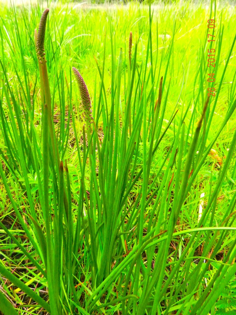
 Triglochin maritima grows in the marsh of Gooch Creek
Each year I harvest last years stems of Phragmites in my estuary/marsh for mason bee tubes. It is important that this is done in the early spring only before new shoots start to emerge. I have a theory that this native Phragmites exists in this particular marsh only because the marsh was fenced in the early years to prevent grazing by cattle and sheep. It has been eliminated from most of the other marshes in BC by grazing (personal communication with Robert Prescott-Allen). The reason this marsh was fenced probably was that the plant Triglochin maritima (Sea arrow grass) grows in the marsh and it is toxic to grazers. ( see below)
Scientific classification
Kingdom: Plantae
(unranked): Angiosperms
(unranked): Monocots
Order: Alismatales
Family: Juncaginaceae
Genus: Triglochin
Species: T. maritima
Binomial name
Triglochin maritima L.
The following is a quote from the Canadian Biodiversity Information facility:
Seaside arrow-grass (Triglochin maritima) is a native plant found sporadically across Canada in saline, brackish, or fresh marshes and shores. This plant contains cyanogenic glycosides, which can release HCN during mastication by animals. Poisoning occurs primarily with ruminants, including cattle and sheep. The concentration of toxic chemicals increases during times of moisture depletion (Majak et al. 1980, Cooper and Johnson 1984, Poulton 1989).
Go to ITIS*ca for more taxonomic information on: Triglochin maritima
Cyanide poisoning from seaside arrow-grass is similar to symptoms discussed under sheep.
Cyanide poisoning of sheep by seaside arrow-grass includes the following symptoms: nervousness, trembling, erratic breathing, convulsions, recumbency, and death. Postmortem findings reveal bright red blood and the smell of bitter almonds in the stomach. Treatment, if started early enough, can be successful. Intravenous injections of an aqueous solution of sodium thiosulfate have proved to be effective (Cooper and Johnson 1984).
This article is of particular importance to Metchosin since we have ongoing efforts in creating seawalls with the intent of protecting property.
Multiscale impacts of armoring on Salish Sea shorelines: Evidence for cumulative and threshold effects Megan N. Dethier a, * Jeffery R. Cordell c
a Friday Harbor Laboratories, University of Washington, Friday Harbor, WA 98250, USA
b Skagit River System Cooperative, LaConner, WA 98257, USA c School of Aquatic and Fishery Sciences, University of Washington, Seattle, WA 98195, USA d School of Oceanography, University of Washington, Seattle, WA 98195, USA e Washington State Department of Natural Resources, Olympia, WA 98504, USA, Wendel W. Raymond a, Andrea S. Ogston d, Aundrea N. McBride b, Sarah M. Heerhartz c
abstract:
Shoreline armoring is widespread in many parts of the protected inland waters of the Pacific Northwest,U.S.A, but impacts on physical and biological features of local nearshore ecosystems have only recently begun to be documented. Armoring marine shorelines can alter natural processes at multiple spatial and temporal scales; some, such as starving the beach of sediments by blocking input from upland bluffs may take decades to become visible, while others such as placement loss of armoring construction are im-
mediate. We quantified a range of geomorphic and biological parameters at paired, nearby armored and unarmored beaches throughout the inland waters of Washington State to test what conditions and parameters are associated with armoring. We gathered identical datasets at a total of 65 pairs of beaches: 6 in South Puget Sound, 23 in Central Puget Sound, and 36 pairs North of Puget Sound proper. At this broad scale, demonstrating differences attributable to armoring is challenging given the high natural variability in measured parameters among beaches and regions. However, we found that armoring was
consistently associated with reductions in beach width, riparian vegetation, numbers of accumulated logs, and amounts and types of beach wrack and associated invertebrates. Armoring-related patterns at lower beach elevations (further vertically from armoring) were progressively harder to detect. For some parameters, such as accumulated logs, there was a distinct threshold in armoring elevation that was associated with increased impacts. This large dataset for the first time allowed us to identify cumulative impacts that appear when increasing proportions of shorelines are armored. At large spatial and temporal scales, armoring much of a sediment drift cell may result in reduction of the finer grain-size
fractions on beaches, including those used by spawning forage fish. Overall we have shown that local impacts of shoreline armoring can scale-up to have cumulative and threshold effects – these should be considered when managing impacts to public resources along the coast. © 2016 Elsevier Ltd. All rights reserved.
Since the 25th of November, we have had 5 inches of precipitation and in the last two weeks an unusual number of South-Easterly storms providing great action at Taylor beach in front of the farm, especially at high tide. The view starts by looking towards William Head prison and ends with a view of Victoria in the distance
In determining the importance of the watershed that connects with our shoreline, the word Riparian often surfaces. In the National Energy Board KM/TMX hearings, the pdf enclosed was one of the reports presented. It gives a well-researched description of the definition of Riparian along with the implications for development which impinges upon such areas.
This was originally filed at : https://docs.neb-one.gc.ca/ll-eng/llisapi.dll/fetch/2000/90464/90552/548311/956726/2392873/2449925/2450952/2798050/C301-15-1_-_IR_From_Salmon_River_Enhancement_Society_to_Pipeup_-_A4Q7W6_SRES_RESPONSE_compressed_-_A4R4F2.pdf?nodeid=2797843&vernum=-2
QUOTE” “Role of Riparian Habitat in Streams Why is the Riparian Area Important? Riparian areas and the vegetation and structure associated with this component of aquatic environments in streams and lakes comprise critical habitats for many species, including commercial, recreational and aboriginal (CRA) fishery fishes. A riparian zone, or riparian area, is the water/land interface between the terrestrial upland area and a river or stream (Figure 1). Plant communities along the edge of streams or lakes are usually referred to as the riparian vegetation (Figure 2). The plant community within a riparian area often is dominated by hydrophilic species, but not always (Figure 2). In British Columbia watercourses that support CRA fisheries rely profoundly on intact and functional riparian areas (viz., Forest and Range Practices Act https://www.for.gov.bc.ca/code/ Table 1; Riparian Areas Regulation http://www2.gov.bc.ca/gov/content/environment/plants-animalsecosystems/fish/riparian-areas-regulation Table 2). To reiterate, the scientific literature is very clear that riparian areas comprise critical habitats for both fishes and other species (Wenger 1999, Broadmeadow and Nisbet 2004). The role of riparian habitats is elegantly described by excerpts in the following quotes: Riparian buffers are important for good water quality [in streams]. Riparian zones help to prevent [deleterious] sediment[s], nitrogen, phosphorus, pesticides and other pollutants from C301 – Salmon River Enhancement Society 3 reaching a stream. Riparian buffers are most effective at improving water quality when they include a native grass or herbaceous filter strip along with deep rooted trees and shrubs along the stream. Riparian vegetation is a major source of energy and nutrients for stream communities. They are especially important in small, headwater streams where up to 99% of the energy input may be from woody debris and leaf litter. [Invertebrates associated with this and instream vegetation contribute as fish food.] Overhanging riparian vegetation keeps streams cool, [and] this is especially important for…mountain trout [i.e., salmonid] populations. Riparian buffers provide valuable habitat for wildlife. In addition to providing food and cover they are an important corridor or travel [path]way[s] for a variety of wildlife. Forested streamsides benefit game species [e.g., deer and bear]…and nongame species like migratory songbirds. Riparian vegetation slows floodwaters, thereby helping to maintain stable streambanks and protect downstream property. By slowing down floodwaters and rainwater runoff, the riparian vegetation allows water to soak into the ground and recharge groundwater. Slowing floodwaters allows the riparian zone to function as a site of sediment deposition, trapping sediments that build stream banks and would otherwise degrade our streams and rivers. [http://www.bae.ncsu.edu/programs/extension/wqg/sri/riparian5.pdf Accessed 6 July 2015.] The critical nature of riparian areas to a properly functioning stream cannot be overstated. As Tschaplinski and Pike (2009), in their analysis of the function of riparian areas to British Columbia streams, point out “No other landscape features within forests provide linkages that are as extensive and complex as those provided by riparian ecotones.” Tschaplinski and Pike (2009) go further to indicate that riparian areas contain and support many of the highest-value resources in natural forests and quote Hartman and Scrivener (1990) as evidence. In another citation, Gregory et al. (1991) indicate that the plant and animal communities in riparian areas frequently have the highest species richness found in forests. The issues relating to riparian areas are particularly relevant to the Trans Mountain Expansion Project (TMEP) as many of the streams crossed by the pipeline construction are typical of the watercourses that Tschaplinski and Pike (2009) and others refer to in respect to the importance of the role of riparian vegetation and the zone as fish habitat. And riparian areas are key habitats that TMEP will destroy as a function of crossing the streams where trenching will take place.See the full PDF:Ripariandefinition-_IR_From_Salmon_River_Enhancement_Society_to_Pipeup_-_A4Q7W6_SRES_RESPONSE_compressed_-_A4R4F2”
Last week we had a very high tide, and storms from the north-east which had temporarily blocked the exit to Gooch Creek on Taylor Beach. The water in Gooch creek swamp rose over a metre before breaking through and washing out on the beach. As the beach has eroded down, the record of the previous weeks of tide levels and storm surges is exposed in this eroding bank where the water exits on the beach.