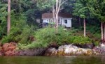
In the fall of 2021, a cliff stabilization exercise was carried out along with the re-establishment of the stairway down to Witty’s Beach . Cuttings of willow were planted in the area of the back that had been eroding.
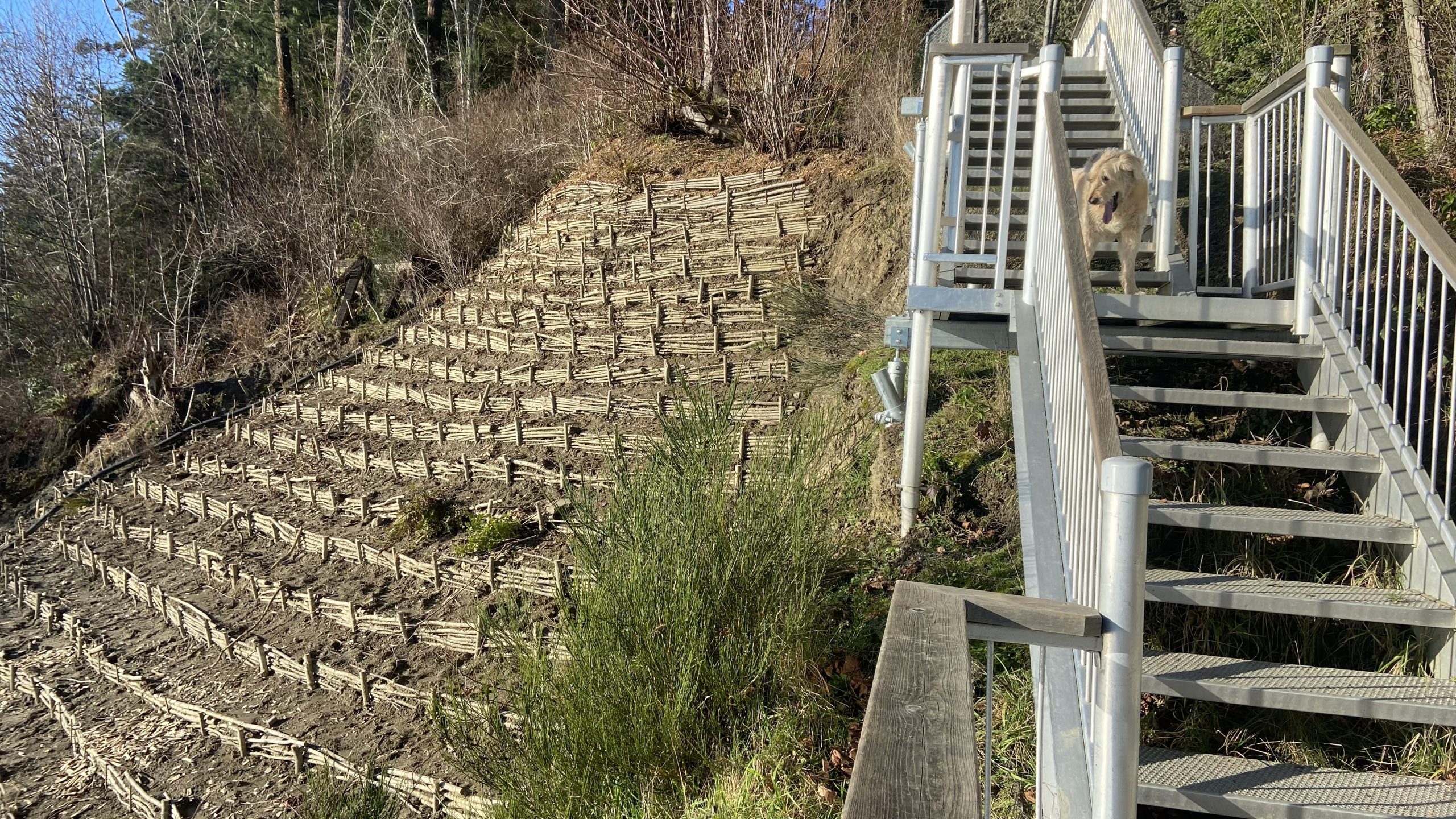
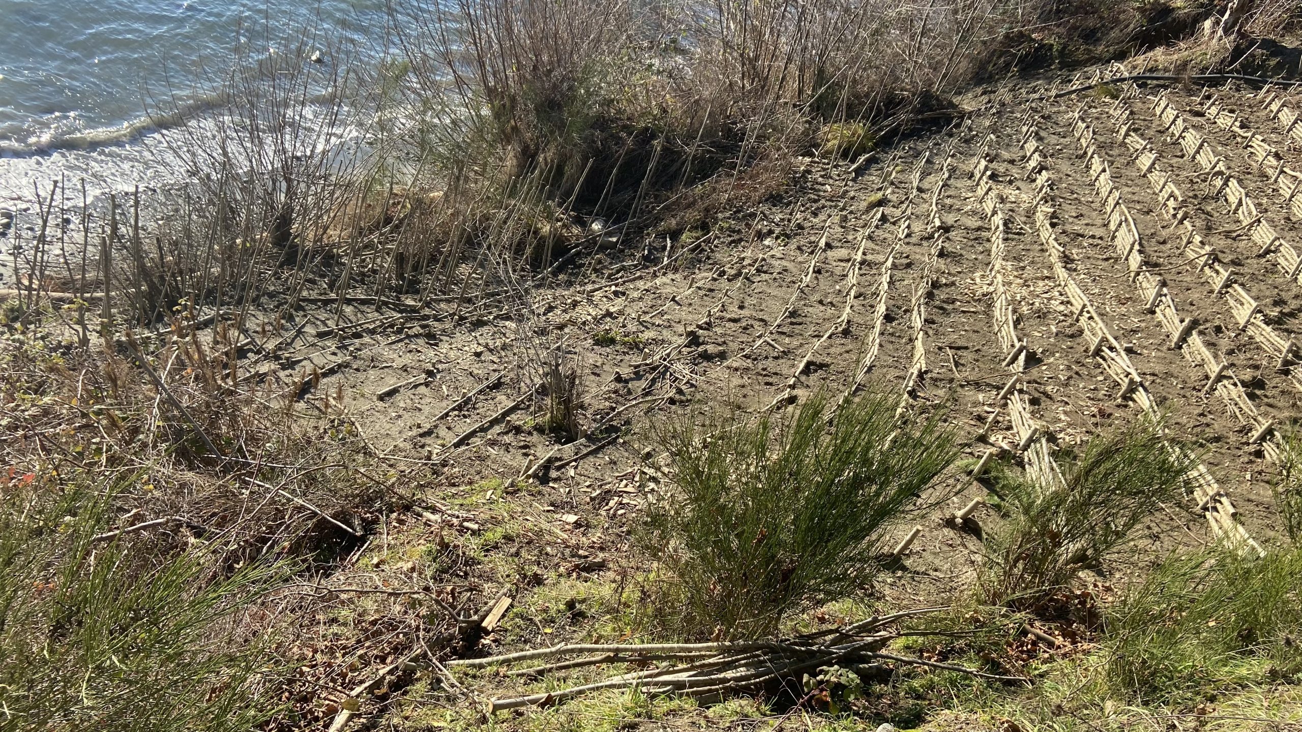
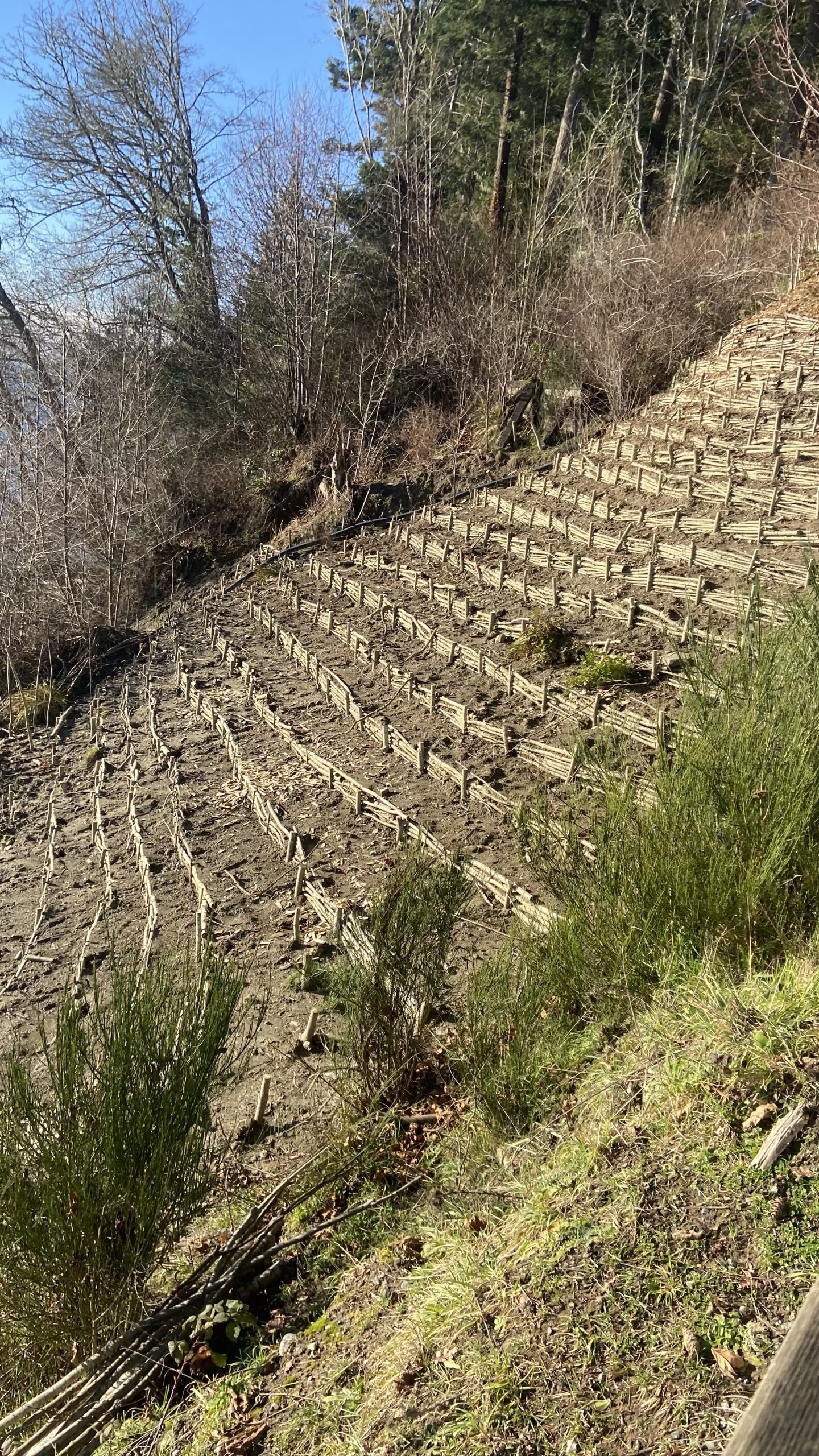
In the fall of 2021, a cliff stabilization exercise was carried out along with the re-establishment of the stairway down to Witty’s Beach . Cuttings of willow were planted in the area of the back that had been eroding.
This article is of particular importance to Metchosin since we have ongoing efforts in creating seawalls with the intent of protecting property.
Multiscale impacts of armoring on Salish Sea shorelines: Evidence for cumulative and threshold effects Megan N. Dethier a, * Jeffery R. Cordell c
a Friday Harbor Laboratories, University of Washington, Friday Harbor, WA 98250, USA
b Skagit River System Cooperative, LaConner, WA 98257, USA c School of Aquatic and Fishery Sciences, University of Washington, Seattle, WA 98195, USA d School of Oceanography, University of Washington, Seattle, WA 98195, USA e Washington State Department of Natural Resources, Olympia, WA 98504, USA, Wendel W. Raymond a, Andrea S. Ogston d, Aundrea N. McBride b, Sarah M. Heerhartz c
abstract:
Shoreline armoring is widespread in many parts of the protected inland waters of the Pacific Northwest,U.S.A, but impacts on physical and biological features of local nearshore ecosystems have only recently begun to be documented. Armoring marine shorelines can alter natural processes at multiple spatial and temporal scales; some, such as starving the beach of sediments by blocking input from upland bluffs may take decades to become visible, while others such as placement loss of armoring construction are im-
mediate. We quantified a range of geomorphic and biological parameters at paired, nearby armored and unarmored beaches throughout the inland waters of Washington State to test what conditions and parameters are associated with armoring. We gathered identical datasets at a total of 65 pairs of beaches: 6 in South Puget Sound, 23 in Central Puget Sound, and 36 pairs North of Puget Sound proper. At this broad scale, demonstrating differences attributable to armoring is challenging given the high natural variability in measured parameters among beaches and regions. However, we found that armoring was
consistently associated with reductions in beach width, riparian vegetation, numbers of accumulated logs, and amounts and types of beach wrack and associated invertebrates. Armoring-related patterns at lower beach elevations (further vertically from armoring) were progressively harder to detect. For some parameters, such as accumulated logs, there was a distinct threshold in armoring elevation that was associated with increased impacts. This large dataset for the first time allowed us to identify cumulative impacts that appear when increasing proportions of shorelines are armored. At large spatial and temporal scales, armoring much of a sediment drift cell may result in reduction of the finer grain-size
fractions on beaches, including those used by spawning forage fish. Overall we have shown that local impacts of shoreline armoring can scale-up to have cumulative and threshold effects – these should be considered when managing impacts to public resources along the coast. © 2016 Elsevier Ltd. All rights reserved.
In determining the importance of the watershed that connects with our shoreline, the word Riparian often surfaces. In the National Energy Board KM/TMX hearings, the pdf enclosed was one of the reports presented. It gives a well-researched description of the definition of Riparian along with the implications for development which impinges upon such areas.
This was originally filed at : https://docs.neb-one.gc.ca/ll-eng/llisapi.dll/fetch/2000/90464/90552/548311/956726/2392873/2449925/2450952/2798050/C301-15-1_-_IR_From_Salmon_River_Enhancement_Society_to_Pipeup_-_A4Q7W6_SRES_RESPONSE_compressed_-_A4R4F2.pdf?nodeid=2797843&vernum=-2
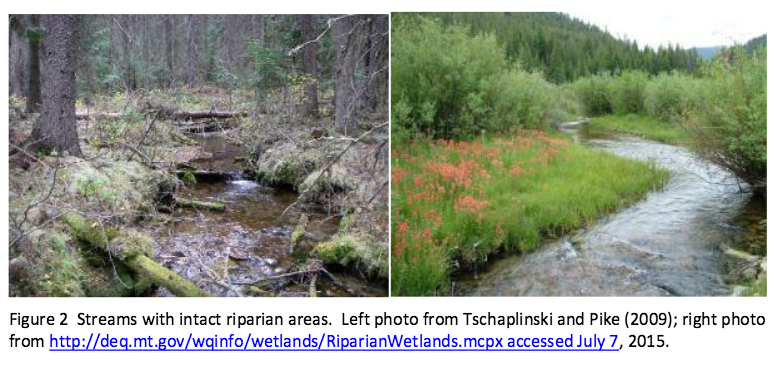
QUOTE” “Role of Riparian Habitat in Streams Why is the Riparian Area Important? Riparian areas and the vegetation and structure associated with this component of aquatic environments in streams and lakes comprise critical habitats for many species, including commercial, recreational and aboriginal (CRA) fishery fishes. A riparian zone, or riparian area, is the water/land interface between the terrestrial upland area and a river or stream (Figure 1). Plant communities along the edge of streams or lakes are usually referred to as the riparian vegetation (Figure 2). The plant community within a riparian area often is dominated by hydrophilic species, but not always (Figure 2). In British Columbia watercourses that support CRA fisheries rely profoundly on intact and functional riparian areas (viz., Forest and Range Practices Act https://www.for.gov.bc.ca/code/ Table 1; Riparian Areas Regulation http://www2.gov.bc.ca/gov/content/environment/plants-animalsecosystems/fish/riparian-areas-regulation Table 2). To reiterate, the scientific literature is very clear that riparian areas comprise critical habitats for both fishes and other species (Wenger 1999, Broadmeadow and Nisbet 2004). The role of riparian habitats is elegantly described by excerpts in the following quotes: Riparian buffers are important for good water quality [in streams]. Riparian zones help to prevent [deleterious] sediment[s], nitrogen, phosphorus, pesticides and other pollutants from C301 – Salmon River Enhancement Society 3 reaching a stream. Riparian buffers are most effective at improving water quality when they include a native grass or herbaceous filter strip along with deep rooted trees and shrubs along the stream. Riparian vegetation is a major source of energy and nutrients for stream communities. They are especially important in small, headwater streams where up to 99% of the energy input may be from woody debris and leaf litter. [Invertebrates associated with this and instream vegetation contribute as fish food.] Overhanging riparian vegetation keeps streams cool, [and] this is especially important for…mountain trout [i.e., salmonid] populations. Riparian buffers provide valuable habitat for wildlife. In addition to providing food and cover they are an important corridor or travel [path]way[s] for a variety of wildlife. Forested streamsides benefit game species [e.g., deer and bear]…and nongame species like migratory songbirds. Riparian vegetation slows floodwaters, thereby helping to maintain stable streambanks and protect downstream property. By slowing down floodwaters and rainwater runoff, the riparian vegetation allows water to soak into the ground and recharge groundwater. Slowing floodwaters allows the riparian zone to function as a site of sediment deposition, trapping sediments that build stream banks and would otherwise degrade our streams and rivers. [http://www.bae.ncsu.edu/programs/extension/wqg/sri/riparian5.pdf Accessed 6 July 2015.] The critical nature of riparian areas to a properly functioning stream cannot be overstated. As Tschaplinski and Pike (2009), in their analysis of the function of riparian areas to British Columbia streams, point out “No other landscape features within forests provide linkages that are as extensive and complex as those provided by riparian ecotones.” Tschaplinski and Pike (2009) go further to indicate that riparian areas contain and support many of the highest-value resources in natural forests and quote Hartman and Scrivener (1990) as evidence. In another citation, Gregory et al. (1991) indicate that the plant and animal communities in riparian areas frequently have the highest species richness found in forests. The issues relating to riparian areas are particularly relevant to the Trans Mountain Expansion Project (TMEP) as many of the streams crossed by the pipeline construction are typical of the watercourses that Tschaplinski and Pike (2009) and others refer to in respect to the importance of the role of riparian vegetation and the zone as fish habitat. And riparian areas are key habitats that TMEP will destroy as a function of crossing the streams where trenching will take place.See the full PDF:Ripariandefinition-_IR_From_Salmon_River_Enhancement_Society_to_Pipeup_-_A4Q7W6_SRES_RESPONSE_compressed_-_A4R4F2”
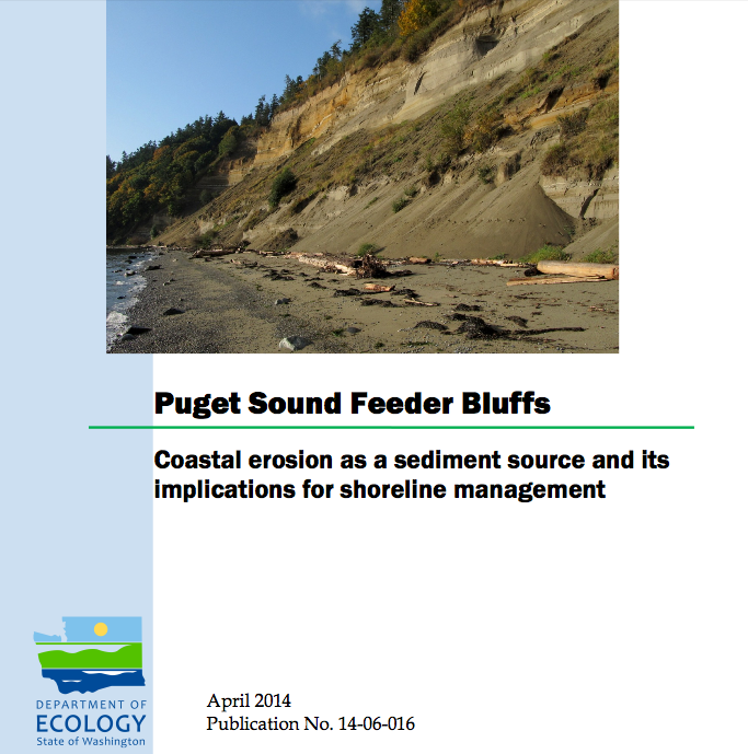
This report examines the role of eroding bluffs as a source of sediment for Puget Sound beaches and includes a review of related geology and coastal processes. It summarizes recent mapping of feeder bluffs and examines ways in which this information can be used to improve shoreline management.
This report is one part of a larger project on Puget Sound feeder bluffs that also includes maps and a series of web pages that cover much of the material in this report. The project was funded by EPA and the WA Department of Fish and Wildlife. Hugh Shipman and colleagues published this important report on feeder bluffs processes and management. Coastal Watershed Index of Port Angeles has been working on the complex and critical topic of feeder bluff management for over a decade. One of their biggest challenges is imparting the critical and unique elements of feeder bluff function and management (including the reality that there are no ‘soft armoring’ techniques appropriate for this land form ). This report provides scientific and management focus specifically to feeder bluffs of the Salish Sea- it’s long overdue.
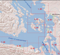
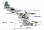
Part 2 is of the maps of feeder bluffs of Puget sound:
Accessed Nov 4, 2014 at :
https://fortress.wa.gov/ecy/publications/SummaryPages
Maps: https://fortress.wa.gov/ecy/publications/publications/1406016part2.pdf/1406016.html.
See More on Feeder Bluff mapping:
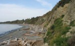
Living on a steep coastal bluff with million dollar views may be a dream of many, but with it comes a few responsibilities. The references on development along coastal areas provides many examples of how development has to be done responsibly. One aspect of concern is vegetation removal and tree cutting and topping on cliffs in order to provide better views to the landowner. In Metchosin, two areas, the Albert Head Cliffs and the Taylor Beach Cliffs provide many examples of this.
In April of 2013 the sound of a chainsaw on the Taylor cliffs led to the discovery of many alder trees on the almost vertical slope that had been topped and even a few arbutus trees had been cut down.
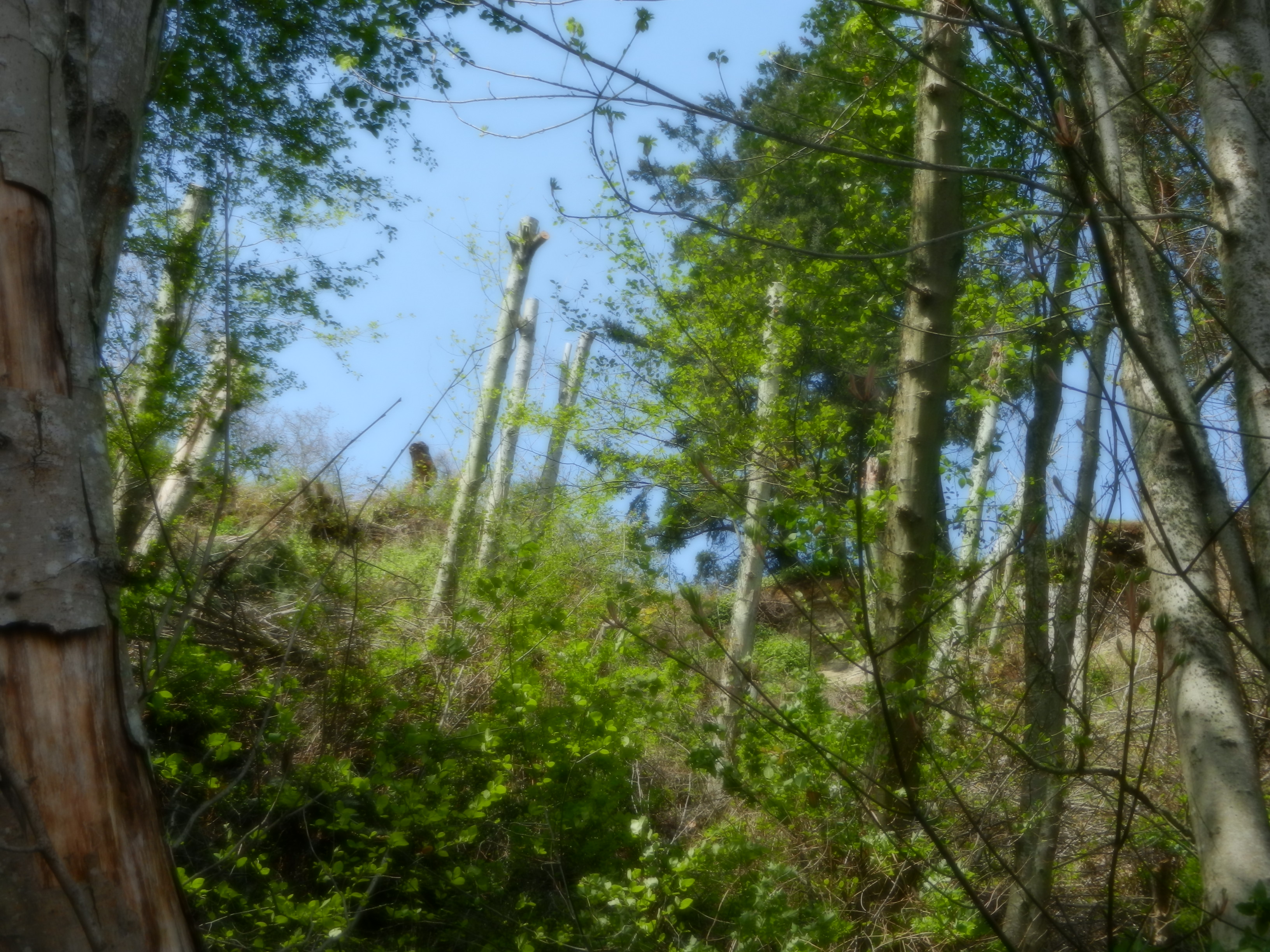
Topped Alder Trees on the Taylor Beach Cliffs
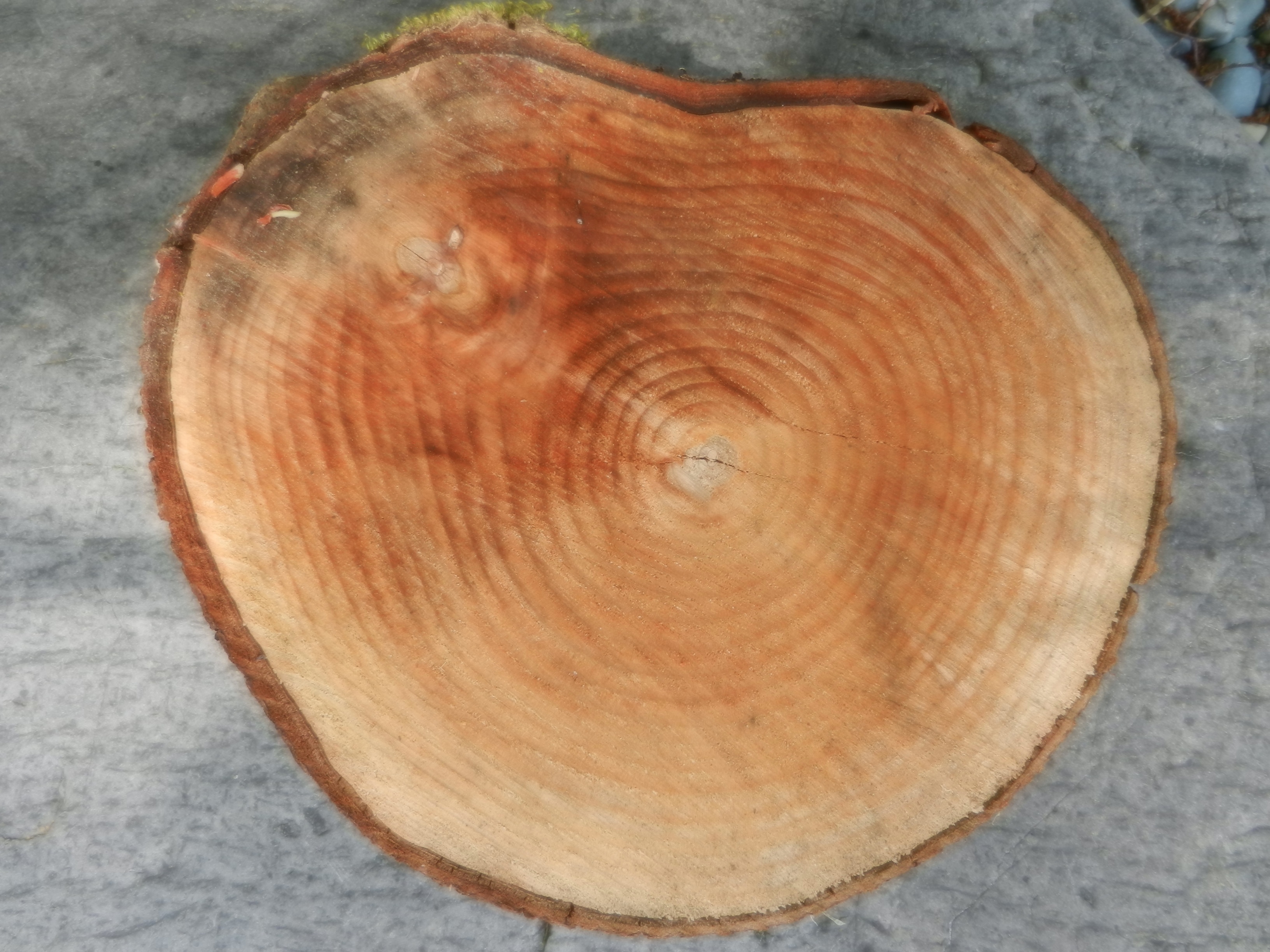 These trees were about 25 years old as can be seen by the tree rings on chunks of trees that had rolled down to the beach.
It might be pointed out that these trees are from the area of Metchosin’s Coastline included in the development permit zone.
This reference from the Center for Ocean Solutions points out he problems of interferring with natural processes on an seaside cliff given the threats of climate change and sea level rise.
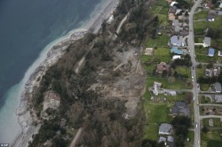
Photo of slope failure from Mail Online
A good example taken from “Mail Online” of what slope failure looked like on Whidbey Island.
 And if one still has doubts, check out these images :
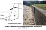
“Seawalls damage virtually every beach they are built on. If they are built on eroding beaches—-and they are rarely built anywhere else,—-they eventually destroy the beach. ” –Cornelia Dean, (Science Editor of the New York Times) Against the Tide, The Battle of America’s Beaches 53 (1999)
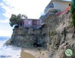
A serious problems which has developed on the coastline of Metchosin, is the building of seawalls under the pretext of protecting private property from erosion. Owners of properties along a coast are often not aware of the mechanics of the interaction with ocean energy of the shoreline. After an intense storm, evidence of erosion along a shore-front often leads land owners, desperate to save their property to go to often very expensive extremes in order to try to protect their property.
A survey of literature from various parts of the world indicates this is not only a local problem, but is indeed very wide spread. The series of photographs documented on this website from Puget Sou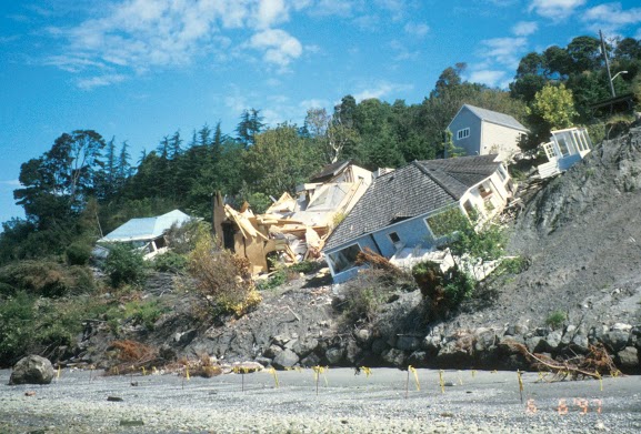 nd, show the problem not far from our shores. We should consider ourselves lucky so far in Metchosin as we have yet to experience the disasters that have happened in Puget Sound. This link to an Image Gallery shows how bad it could get:
Impact of Coastal Erosion in Australia 7 Mar, 2013
Senior Coastal Scientist at Coastalwatch Professor Andrew Short has compiled a comprehensive piece focusing on coastal erosion in Australia.
For the 50% of the Australian coast that is composed of sand and in some places mud, the shoreline is prone to change, building seaward and in some places eroding landward. In most locations this is a natural process with usually no impact on human settlement. Coastal protection of the shoreline is rarely required in Australia, however in a few locations the dynamic shoreline has become a problem, in some cases a major and expensive problem, and in almost all of these cases the problem is related to human interference or encroachment on the shoreline. Coastal protection works, such as breakwaters, groynes, or seawalls, are usually built to guard against erosion. In doing so they harden the coast and reduce its ability to adjust naturally. As a consequence, these defences can exacerbate further erosional problems, with seawalls reflecting and concentrating wave energy and erosion, and groynes starving downdrift the coast of sediment thereby leading to further erosion. There are areas where human have encroached into the dynamic beach environment only to suffer the consequences, and others where they have interfered with coastal processes leading to accelerated coastal erosion.
Executive Summary
See the full PDF version: Seawall
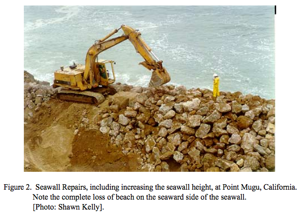 When coastal buildings or roads are threatened, the typical response is to harden the coast with a seawall. Seawalls run parallel to the beach and can be built of concrete, wood, steel, or boulders. Seawalls are also called bulkheads or revetments; the distinction is mainly a matter of purpose. They are designed to halt shoreline erosion caused primarily by wave action. If seawalls are maintained, they may temporarily hold back the ocean from encroaching on shoreline development. In spite of their ability to hold back the ocean, when waves hit a seawall, the waves are reflected back out to sea, taking beach sand with them and eventually causing the beach to disappear. Moreover, seawalls can cause increased erosion at the ends of the seawall on an adjacent beach that is not walled. Alternatives to seawalls exist, such as beach nourishment and managed retreat. Making coastal land use decisions that ensure a seawall will not be needed in the
“The Streisand effect”
In Canto 21 of the Inferno, Dante watches lawyers who made a habit of bringing frivolous or oppressive suits being perpetually submerged in a lake of boiling tar by demons with boathooks. They get off quite lightly, in other words. But perhaps hell of a different kind awaits on earth. It’s called the Streisand Effect. In 2003 Barbra Streisand’s lawyers launched an action to have an aerial photograph of her home in Malibu removed from a collection of 12,000 such shots, whose purpose was to document coastal erosion(11). They demanded $50m in damages. Before they became involved, the photo was downloaded four times. In the month after they launched their stupid suit, it was downloaded 420,000 times(12). “The Streisand Effect,” in other words, is blowback: disastrous unintended consequences of an attempt at censorship.”
These links to external sources on this post are focused on the interactions with Humans in Coastal Areas.
 |
CRD– Limit the Impacts of Shoreline and Streamside Development |
 |
CRD–Protecting Shorelines and Streamsides |
 |
CRD –Rocky Shorelines |
 |
Shoreline Structures Environmental Design ( pdf file) – A Guide for Structures along Estuaries and Large Rivers |
 |
From Green Shores–The Green Shores program promotes sustainable use of coastal ecosystems through planning and design that recognizes the ecological features and functions of coastal systems. |
 |
Coastal Sediment Processes |
 |
Climate Change and Coastal Shores In British Columbia |
 |
Center for Ocean Solutions: Coastal Erosion and Climate Change |
 |
Climate Change : Pacific NW of USA Impacts on Coastal Areas |
 |