Preparing for Climate Change: DPAs

From:
PREPARING FOR CLIMATE CHANGE:
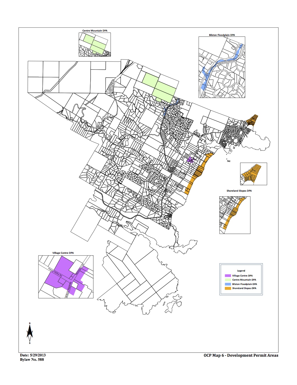
Page 35 Development Permit Areas
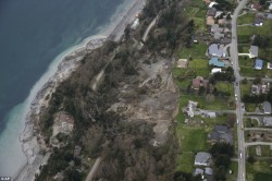
Creating a DPA is a way to shape the development or redevelopment of a given area, and guidelines for the DPA (in the OCP or in a zoning bylaw) can include both broad prescriptions for land use as well as site specific requirements. Preparing for climate change impacts may mean updating existing DPAs to account for different levels of risk or changes to best practices, or in some cases developing new DPAs. There is already well-established practice in BC with respect to using DPAs to manage land use in areas with defined hazards, such as interface wildfires, or slope stability issues and many examples to draw on. DPAs for wildfire hazards may also include requirements about landscaping and the siting, form, exterior design and finish of buildings. DPAs can also be used to restrict development and protect and/or restore natural features and areas, and can be used to help protect key natural ecosystems in the face of climate change.
DPAs can offer local governments a more flexible approach to regulating development than zoning because guidelines can specify results and allow site-specific solutions. For example, a DPA can specify a certain level of onsite stormwater infiltration, while a zoning bylaw could only specify the site coverage allowed.
The Local Government (Green Communities) Statutes Amendment Act (2008) created the opportunity for new types of DPAs, including those designed to promote energy and water conservation. Local governments can employ these DPAs to help make their communities more resilient to climate change impacts like water shortages and potential disruptions in centralized energy supply due to heavy seasonal demand or extreme weather events. Like
DPAs for wildfire hazards, they may also include requirements about landscaping and the siting, form, exterior design and finish of buildings to further energy and water conservation and greenhouse gas reduction goals. For more information see
DPAs can offer local governments a more flexible approach to regulating development than zoning because guidelines can specify results and allow site- specific solutions.

An Implementation Guide for Local Governments in British Columbia DPAs for energy and water conservation may also establish restrictions on the type and placement of trees and other vegetation in proximity to the buildings and other structures in order to provide for the conservation of energy, which can be considered in the context of reducing the heat island effect in urban areas. DPAs can be used together with complementary measures such as servicing requirements, development cost charges and other local government tools to achieve climate change adaptation objectives


DEVELOPMENT PERMIT AREAS: Local Government Act, ss. 919.1-920
In an OCP a local government may designate areas within its jurisdiction where development permits are required before any subdivision, rezoning, construction or (in some cases) any disturbance of the land may occur, the reason the development permit is required, along with guidelines outlining the requirements for obtaining a development permit (which may be in the OCP or a zoning bylaw). The range of purposes that may be relied on for creating development permit areas is quite broad. Those of most interest with respect to climate change adaptation measures are likely protection of the natural environment, protection of the community from hazardous conditions, and establishing objectives to promote conservation of water and energy

Hardening of the Shorelines: Principles

The following is from :
Shorelines Modification , by the State of Washington Dept of Ecology

(ii) Principles. Shorelines are by nature unstable, although in varying degrees. Erosion and accretion are natural processes that provide ecological functions and thereby contribute to sustaining the natural resource and ecology of the shoreline. Human use of the shoreline has typically led to hardening of the shoreline for various reasons including reduction of erosion or providing useful space at the shore or providing access to docks and piers. The impacts of hardening any one property may be minimal but cumulatively the impact of this shoreline modification is significant.

Shoreline hardening typically results in adverse impacts to shoreline ecological functions such as:

  • Beach starvation. Sediment supply to nearby beaches is cut off, leading to “starvation” of the beaches for the gravel, sand, and other fine-grained materials that typically constitute a beach.
  • Habitat degradation. Vegetation that shades the upper beach or bank is eliminated, thus degrading the value of the shoreline for many ecological functions, including spawning habitat for salmonids and forage fish.
  • Sediment impoundment. As a result of shoreline hardening, the sources of sediment on beaches (eroding “feeder” bluffs) are progressively lost and longshore transport is diminished. This leads to lowering of down-drift beaches, the narrowing of the high tide beach, and the coarsening of beach sediment. As beaches become more coarse, less prey for juvenile fish is produced. Sediment starvation may lead to accelerated erosion in down-drift areas.
  • Exacerbation of erosion. The hard face of shoreline armoring, particularly concrete bulkheads, reflects wave energy back onto the beach, exacerbating erosion.
  • Ground water impacts. Erosion control structures often raise the water table on the landward side, which leads to higher pore pressures in the beach itself. In some cases, this may lead to accelerated erosion of sand-sized material from the beach.
  • Hydraulic impacts. Shoreline armoring generally increases the reflectivity of the shoreline and redirects wave energy back onto the beach. This leads to scouring and lowering of the beach, to coarsening of the beach, and to ultimate failure of the structure.
  • Loss of shoreline vegetation. Vegetation provides important “softer” erosion control functions. Vegetation is also critical in maintaining ecological functions.
  • Loss of large woody debris. Changed hydraulic regimes and the loss of the high tide beach, along with the prevention of natural erosion of vegetated shorelines, lead to the loss of beached organic material. This material can increase biological diversity, can serve as a stabilizing influence on natural shorelines, and is habitat for many aquatic-based organisms, which are, in turn, important prey for larger organisms.
  • Restriction of channel movement and creation of side channels. Hardened shorelines along rivers slow the movement of channels, which, in turn, prevents the input of larger woody debris, gravels for spawning, and the creation of side channels important for juvenile salmon rearing, and can result in increased floods and scour.

Additionally, hard structures, especially vertical walls, often create conditions that lead to failure of the structure. In time, the substrate of the beach coarsens and scours down to bedrock or a hard clay. The footings of bulkheads are exposed, leading to undermining and failure. This process is exacerbated when the original cause of the erosion and “need” for the bulkhead was from upland water drainage problems. Failed bulkheads and walls adversely impact beach aesthetics, may be a safety or navigational hazard, and may adversely impact shoreline ecological functions.

Hard” structural stabilization measures refer to those with solid, hard surfaces, such as concrete bulkheads, while “soft” structural measures rely on less rigid materials, such as biotechnical vegetation measures or beach enhancement. There is a range of measures varying from soft to hard that include:

  • Vegetation enhancement;
  • Upland drainage control;
  • Biotechnical measures;
  • Beach enhancement;
  • Anchor trees;
  • Gravel placement;
  • Rock revetments;
  • Gabions;
  • Concrete groins;
  • Retaining walls and bluff walls;
  • Bulkheads; and
  • Seawalls.

Generally, the harder the construction measure, the greater the impact on shoreline processes, including sediment transport, geomorphology, and biological functions.

District of Metchosin Official Community Plan Section on Shoreline Slopes Development Permit Areas

From the Official Community Plan : Available at this link

Map6_Development_Permit_Areas

DPAs in Metchosin ( click to enlarge)

2.16    SHORELAND SLOPES DEVELOPMENT PERMIT AREAS:
The Municipal Act
provides that a community plan may designate development areas to be protected from hazardous conditions. The Municipal Act further provides that in such areas land shall not be altered in any way or subdivided and structures not be built or added to until a Development Permit has been  issued. Council has established the following designation, special conditions, and guidelines.

2.16.1    Designation:  (Bylaw 418, 2004)
The 1993 Hazard Land Management Plan has identified areas of the Metchosin shoreland slopes as having erosion, land sloughing and drainage problems.

AlbertHead portion of DPAs

Farhill Road portion of DPAs,

southsectionDPA

Parry Bay ( Taylor Beach ) section of DPA lands

The Shoreland Slopes areas are shown on Map 6 Shoreline Slopes DPA, and are hereby designated as areas for the protection of development from hazardous conditions pursuant to Section 919.1(1)(b) of the Local Government Act.
The Plan has identified three Shoreland Slope classification zones, based on the degree of slope instability and surface erosion potential. Slopes classified as zone 2 and 3 are slopes with the greatest potential for sloughing, slumping and debris flows and have been included in the Development Permit Area.
2.16.2    Special Conditions:
The major concern is that lands, particularly in the Park Drive – Farhill Road area, have experienced a  dramatic rise in ground water levels due to adjacent developments during the last two decades. Other areas of the Shoreland slopes have experienced significant slope erosion in the past. There is a community desire to mitigate any further development related impacts on the marine shorelands.

2.16.3    Policies Development Permits issued shall be in accordance with the following:
(1)    The construction or alteration of buildings on existing lots shall be permitted subject to the Building  Permit process when Council is satisfied that the Development Permit Guidelines (Section 2.14.4) have been met, and, when required, Council is satisfied with the Engineer’s Report (Section 2.14.5).
(2)Where a Development Permit is applied for in conjunction with an application for subdivision approval, rezoning, or both, the Development Permit shall be conditional on the successful completion of those other permits and shall lapse if the subdivision or rezoning is not approved.

2.16.4    Guidelines:
(1)    All applications for new development in the Development Permit Areas shall be required to have an Engineer’s Report (described below).
(2) Removal of vegetation shall be minimized.
(3) House construction, regrading, and excavation of till (including for road building) is not permitted within 60 metres of the edge of the slope except where geotechnical engineering and resource management studies indicate that a lesser setback is acceptable.
page 31

2.16.5    Engineer’s Report:
Before a development permit is issued, the applicant shall be required to furnish a report at his\her expense from a registered professional engineer with geotechnical experience which will certify that the proposed development will produce no adverse impacts on the shoreland slopes and will not place buildings or structures in danger of slope slippage.

The Engineer’s Report shall demonstrate that consideration has been given to the following:
(1)(a) siting and setbacks of development structures, roads, and services,
(b) minimizing paving and impervious materials, and,
(c) implementing infiltration techniques so as to limit runoff;
(2) designing runoff detention ponds, drainage works, or
sediment traps or basins to reduce the flow of  runoff and silt during land clearing and construction.
(3) development near shoreland slopes must address the impact of surface water on slope stability, vegetation and soils, and make recommendations to remedy that already damaged; and
(4) removal of trees (with a valid tree-cutting permit) or other vegetation should be allowed only where  necessary and where alternate vegetation and/or erosion control measures are established. If possible,  stumps should be left in place to provide some soil stabilizing influence until alternative vegetation is  established. Plans delineating extent of vegetation/tree removal (location, species and diameter of trees) and location of proposed construction, ex cavation and/or blasting, may be required.

The DISTRICT, at its discretion, may also submit the Engineer’s Report to review by a second Engineer at the applicant’s expense, and/or directly to the Ministry of Environment for their comments.

2.16.6    Municipal Response, 
The DISTRICT should:
(1) evaluate the feasibility of purchasing environmentally sensitive shorelands for use as park, forest reserve, or greenbelt;
(2) initiate programs to monitor both surface and ground water to establish patterns of change;
(3)work with proximate agencies to establish erosion and land sloughing control measures.

Acanthodoris nanaimoensis–the wine-plumed spiny dorid nudibranch

On May 26 2013, Gretchen Markle reported on a nudibrach
” Today we found two specimens of the grey phase Acanthodoris nanaimoensis (unmistakable with its maroon-tipped rhinopores and gills) on the beach at Chris Pratt’s.” (see location image below.)

gmMay12AnanaimoensisPhylum Mollusca
Class Gastropoda
Subclass Opisthobranchia
Order Nudibranchia
Suborder Doridacea
Family Onchidorididae
Genus Acanthodoris
Species nanaimoensis
Common name: Wine-plumed spiny doris,

The range of this species is Baranof Island, Alaska to Santa Barbara, CA; less common in southern portion of range.

Click on this image from Google Earth 3D for the location.

Shoreline in front of Chris Pratt's place.

Shoreline in front of Chris Pratt’s place.

Henricia pumila–dwarf mottled Henricia

Gretchen Markle reported a new seastar Henricia pumila for the  April 27 Metchosin Bioblitz on the Laird’s beach , south of Taylor Road and north off Weir’s beach (see Google image below). Henricia pumila is an uncommon seastar, having only been officially described in 2010. Phil Lambert confirmed the identification.

See  http://www.mapress.com/zootaxa/2010/f/zt02329p036.pdf

Phylum Echinodermata
Class Asteroidea
Order Spinulosida
Suborder Leptognathina
Family Echinasteridae
Genus Henricia
Species pumila, Eernisse et al., 2010
Common name: Dwarf mottled henricia.

Laura Verghegge and students of Pearson College also reported with an image, this species and an egg mass in East Sooke Park in March of 2013:  http://pearsoncollegemarinescience.wordpress.com/tag/henricia-pumila/
LOCATION: Click for enlargement:
Shoreline in front of Chris Pratt's place.

Shoreline in front of Chris Pratt’s place.


Anything for a View?

Living on a steep coastal bluff with million dollar views may be a dream of many, but with it comes a few responsibilities. The references on development along coastal areas provides many examples of how development has to be done responsibly.  One aspect of concern is vegetation removal and tree cutting and topping on cliffs in order to provide better views to the landowner. In Metchosin, two areas, the Albert Head Cliffs and the Taylor Beach Cliffs provide many examples of this.

In April of 2013 the sound of a chainsaw on the Taylor cliffs led to the discovery of many alder trees on the almost vertical slope that had been topped  and even a few arbutus trees had been cut down.

Topped Alder Trees on the Taylor Beach Cliffs

Topped Alder Trees on the Taylor Beach Cliffs

2013-04-19 aldersectionlThese trees were about 25 years old  as can be seen by the tree rings on chunks of trees that had rolled down to the beach.

It might be pointed out that these trees are from the  area of Metchosin’s Coastline included in the  development permit zone.

This reference from the Center for Ocean Solutions points out he problems of interferring with natural processes on an seaside  cliff given the threats of climate change and sea level rise.

Photo of slope failure from Mail Online

Photo of slope failure from Mail Online

A good example taken from “Mail Online” of what slope failure looked like on Whidbey Island.


perchedoncliffAnd if one still has doubts, check out these images :

Evasterias troscheli–mottled star

These photos taken by Garry Fletcher  on the rocky intertidal at the base of Taylor Bluffs on Parry Bay shows an unusual green phase of the Evasterias troscheli

Kingdom: Animalia
Phylum: Echinodermata
Subphylum: Eleutherozoa
Superclass: Asterozoa
Class: Asteroidea
Order: Forcipulatida
Family: Asteriidae
Genus: Evasterias
Species: E. troscheli
Binomial name: Evasterias troscheli, (Stimpson, 1862)


Metchosin Bioblitz 2013: North end of Sector 7, Taylor Beach

Metchosin  BioBlitz Observations by Garry Fletcher and Sandra______on April 27, 2013 on the floodplane and estuary of Gooch Creek, on the 4645 William Head Road Property.


Continue reading

Metchosin Bioblitz 2011-2012 lists for Sector 7, Weir’s Beach to Taylor Beach Bluffs

PrintSector 7. Weirs and Taylor Beach Bluffs – A variety of cliff face, beach, estuary and rocky shores, with intertidal areas.

 Thanks to Kem Luther for providing the Metchosin Bioblitz Records for this Coastal Sector and to the individuals who examined the area on the day of the Bioblitz , in April, 2012

Species Common name Species-Group  sub-group
Acrosiphonia coalit Greenrope Algae  chlorophyta
Alaria marginata  brown algae Algae  paheophyta
Costaria costata Five-ribbed kelp Algae  phaeophyta
Cystoseira sp Bladder Leaf Alga phaeophyta
Enteromorpha intestinalis Tube weed Algae  chlorophyta
Fucus sp. Rockweed Algae  phaeophyta
Lithothamnion sp.  re encrusting Algae  rhodophyta
Mazaella sp. Iridescent red algae Algae  rhodophyta
Scytosiphon lomentaria Soda Straw Algae  phaeophyta
Stephanocystis geminata Algae  phaeophyta
Ulva lactuca Sea lettuce Algae  chlorophyta
Leucolepis acanthoneuron Palm tree moss Bryophyte Moss moist, rich site
Rhytidiadelphus triquetrus Cat’s paw moss Bryophyte Moss moist, rich site
Balanus crenatus Crenate barnacle Invertebrate Arthropod
Balanus glandula Acorn barnacle Invertebrate Arthropod
Cancer magister Dungeness crab Invertebrate Arthropod
Cancer productus Red rock crab Invertebrate Arthropod
Caprella sp. Skeleton shrimp Invertebrate Arthropod
Chromopleustes oculatus Black and White Sea Flea Invertebrate Arthropod
Chthamalus dalli Little brown barnacle Invertebrate Arthropod
Crangon alaskensis Northern Crangon Invertebrate Arthropod
Gnorimosphaeroma oregonense Stubby Isopod Invertebrate Arthropod
Hemigrapsus nudus Purple Shore Crab Invertebrate Arthropod
Heptacarpus spp Shrimp Invertebrate Arthropod
Idotea wosnesenskii Rockweed isopod Invertebrate Arthropod
Pagurus hirsutiusculus Hairy hermit crab Invertebrate Arthropod
Petrolisthes eriomerus Flattop crab Invertebrate Arthropod
Pugettia gracilis Graceful kelp crab Invertebrate Arthropod
Semibalanus cariosus Thatched barnacle Invertebrate Arthropod
Spirontocaris sp Shrimp Invertebrate Arthropod
Anthopleura elegantissima Aggregating anemone Invertebrate Cnidaria
Urticina crassicornis Painted Anemone Invertebrate Cnidaria
Evasterias troschelli Mottled Star Invertebrate Echinoderm
Pycnopodia helianthoides Sunflower Star Invertebrate Echinoderm
Clinocardium nuttallii Nuttall’s Cockle Invertebrate Mollusc
Littorina scutulata Checkered Periwinkle Invertebrate Mollusc
Littorina sitkana Sitka Periwinkle Invertebrate Mollusc
Lottia digitalis Finger limpet Invertebrate Mollusc
Lottia pelta Shield Limpet Invertebrate Mollusc
Macoma nasuta Bent-nose macoma Invertebrate Mollusc
Macoma secta White Sand Macoma Invertebrate Mollusc
Mopalia liignosa Woody Chiton Invertebrate Mollusc
Mopalia muscosa Mossy Chiton Invertebrate Mollusc
Mytilus  trossulus Pacific Blue Mussel Invertebrate Mollusc
Nucella lamellosa Wrinkled Dogwinkle Invertebrate Mollusc
Nucella ostrina Northern Striped Dog Winkle Invertebrate Mollusc
Nuttallia obscurata Dark Mahogany Clam Invertebrate Mollusc
Rostanga pulchra Red Nudibranch Invertebrate Mollusc
Tectura persona Mask Limpet Invertebrate Mollusc
Tectura
scutum
Shield limpet Invertebrate Mollusc
Tonicella lineata Lined Chiton Invertebrate Mollusc
Eudistylia vancouveri Feather duster worm Invertebrate Polychaete
Schizobranchia sp. Feather duster worm Invertebrate Polychaete
Thelepus sp Spaghetti worm Invertebrate Polychaete
Halichondria sp. Yellow encrusting sponge Invertebrate Porifera
Ophlitaspongia pennata Red Encrusting Sponge Invertebrate Porifera
Pyura haustor Warty Tunicate Invertebrate Tunicate tunicate, not in efauna
Peltigera aphthosa Rock lichen Lichen xeric (rock)
Pentagramma triangularis Goldenback fern Vascular plant Fern sub-xeric
Polystichum munitum Sword fern Vascular plant Fern scattered
Pteridium aquilinum Bracken fern Vascular plant Fern disturbed ground
Achillea millefolium yarrow Vascular plant Forb
Alyssum sp. Alyssum Vascular plant Forb
Ambrosia chamissonis Silver burr ragweed Vascular plant For adjacent to beach
Angelica sp. sea-watch? Vascular plant Forb
Aquilegia formosa Columbin Vascular plant Forb scattered
Brassica campestris Fieldnmustard Vascular plant Forb scatteredn
Cardamine oligosperma Few-seeded bitter-cress Vascular plant Forb mesic
Chenopodium album Lamb’s-quarters Vascular plant Forb open, disturbed area
Cirsium edule Edible thistle Vascular plant Forb toe slopes, exposed
Claytonia perfoliata Miner’s lettuce Vascular plant Forb sub-hygric
Epilobium angustifolium Fireweed Vascular plant Forb base of bluffs
Equisetum arvense Horsetail Vascular plant Forb sandy wet sites
Erodium cicutarium stork’s bill Vascular plant Forb
Galium aparine Cleavers (bedstraw) Vascular plant Forb toe of bluffs
Geranium molle dove’s foot geranium Vascular plant Forb
Geranium robertianum Herb-Robert Vascular plant Forb toe of bank
Geum macrophyllum Large-leaved avens Vascular plant Forb permesic
Heracleum maximum cow-parsnip Vascular plant Forb
Heuchera micrantha Small flowered alumroot Vascular plant Forb occasional
Hyacinthoides sp. bluebells Vascular plant Forb
Hyacinthus orientalis Hyacinth Vascular plant Forb escaped
exotic
Hypochaeris radicata Hairy catsear Vascular plant Forb mesic
Lamium purpureum purple dead nettle Vascular plant Forb
Lathyrus japonicus Beach pea Vascular plant Forb open toe slope, adj. to beach
Linnaea borealis Twinflower Vascular plant Forb shaded forest
Lithophragma parviflorum Small-flowered woodland star Vascular plant Forb occasional
Lysichiton americanus Skunk cabbage Vascular plant Forb on Garry Fletcher’sr’s prop.
Maianthemum  dilatatum False lily of the valley Vascular plant Forb on Garry Fletcher’sr’s prop.
Medicago lupulina Black medic Vascular plant Forb disturbed site
Mitella brewerii Brewer’s mitrewort Vascular plant Forb occasional
Oenanthe sarmentosa Pacific water-parsley Vascular plant Forb sub-hygric
Osmorhiza chilensis sweet-cicely Vascular plant Forb
Phragmites australis Common reed Vascular plant Forb open wet meadow
Plantago sp. plantain Vascular plant Forb
Platanthera sp. rein orchid Vascular plant Forb
Potentilla anserina silverweed Vascular plant Forb
Potentilla anserina Common silverweed Vascular plant Forb marsh adjacent to lagoon
Prunella vulgaris Self-heal Vascular plant Forb moist microsite
Ranunculus occidentalis Western buttercup Vascular plant Forb open areas
Ranunculus sp. buttercups Vascular plant Forb
Ranunculus uncinatus Small-flowered buttercup Vascular plant Forb openings next to beach
Romanzoffia tracyi Tracey’s mistmaiden Vascular plant Forb
Rumex acetosella sheep sorrel Vascular plant Forb
Rumex sp. dock Vascular plant Forb
Saxifraga sp. Saxifrage  Vascular plant Forb
Senecio vulgaris Common groundsel Vascular plant Forb mesic
Sonchus asper Prickly sow thistle Vascular plant Forb not in flower
Stachys sp. hedge nettle Vascular plant Forb
Taraxacum
officinale
Common dandelion Vascular plant Forb adjacent to beach
Taraxacum sp. dandelion Vascular plant Forb
Tellima grandiflora Fringe cup Vascular plant Forb permesic, base of bluffs
Trientalis borealis ssp latifolia Starflower Vascular plant Forb permesic
Trifolium repens White clover Vascular plant Forb  shady, moist site
Urtica dioica stinging nettle Vascular plant Forb
Vicia sativa Common vetch Vascular plant Forb disturbed sites
Elymus mollis Tall beachgrass Vascular plant Grass next to the beach
Poa sp. Bluegrass Vascular plant Grass scattered
Juncus effusus Common rush Vascular plant Rush on Garry Fletcher’sr’s prop.
Carex lyngbyei Lyngby’s sedge Vascular plant Sedge on Garry Fletcher’sr’s prop.
Carex obnupta Slough sedge Vascular plant Sedge on Garry Fletcher’sr’s prop.
Scirpus
americanus
Hard-stemmed bullrush Vascular plant Sedge on Garry Fletcher’sr’s prop.
Amelanchier alnifolia Saskatoon berry/service berry Vascular plant Shrub
Cytisus scoparius Scotch broom Vascular plant Shrub in open areas (introduced)
Daphne laureola spurge-laurel Vascular plant Shrub scattered along bluff face
Gaultheria shallon salal Vascular plant Shrub
Hedera helix English ivy Vascular plant Shrub naturalized
Holodiscus discolor ocean spray Vascular plant Shrub
Ilex sp Holly Vascular plant Shrub naturalized
Lonicera ciliosa orange honeysuckle Vascular plant Shrub
Mahonia nervosa Oregon grape Vascular plant Shrub drier sites
Oemleria cerasiformis Indian plum Vascular plant Shrub mesic and wetter
Ribes lacustre Black gooseberry Vascular plant Shrub toe slopes
Ribes sanguineum Red flowering currant Vascular plant Shrub toe slopes
Rosa nutkana Nootka rose Vascular plant Shrub
Rubus armeniacus Himalayan blackberry Vascular plant Shrub exposed areas (introduced)
Rubus parviflorus thimble berry Vascular plant Shrub
Rubus spectabilis salmon berry Vascular plant Shrub
Rubus ursinus Trailing blackberry Vascular plant Shrub in openings
near toe slopes
Sambucus racemosa red elder Vascular plant Shrub
Symphoricarpos albus snowberry Vascular plant Shrub
Ulex europaeus Gorse Vascular plant Shrub introduced
Abies grandis grand fir Vascular plant Tree
Acer macrophyllum big leaf maple Vascular plant Tree
Alnu rubra red alder Vascular plant Tree
Arbutus menziesii arbutus Vascular plant Tree
Malus fusca Pacific crabapple Vascular plant Tree permesic site
Pinus contorta shore pine Vascular plant Tree
Prunus marginata Bitter cherry Vascular plant Tree permesic site
Pseudotsuga menziesii Douglas fir Vascular plant Tree
Quercus garryana Garry Oak Vascular plant Tree
Salix scouleriana Scouler’s willow Vascular plant Tree above the beach
Salix sitchensis Sitka willow Vascular plant Tree adjacent to the beach
Salix sp. willow Vascular plant Tree
Buteo jamaicensis Red tail hawk Vertebrate Bird in the air above Taylor beach
Haliaeetus leucocephalus Bald eagle Vertebrate Bird in the air east of Taylor beach
Larus glaucescens Glaucus winged gull Vertebrate Bird in the air numerous)
Sphyrapicus ruber Red-naped sapsucker Vertebrate Bird in an alder snag
Blepsias cirrhosus Silverspotted Sculpin Vertebrate Fish
Gobiesox maeandricus Northern Clingfish Vertebrate Fish
Leptocottus armatus Staghorn Sculpin Vertebrate Fish
Liparis florae TidepoolSnailfish Vertebrate Fish
Pholis sp. Gunnel Vertebrate Fish
Lontra canadensis River otter Vertebrate Mammal off Witty’s beach
Oryctolagus cuniculus European rabbit Vertebrate Mammal open grass meadow near lagoon
Phoca vitulina Harbour seal Vertebrate Mammal
Thamnophis sp Garter snake Vertebrate Reptile in the grass adjacentcent to lagoon


Macroalgae ( Kelp) beds around Southern Vancouver Island and their role in Carbon Sequestration .

Sometimes viewed as a nuisance for boaters around the shores of Metchosin, kelp beds (Nereocystis luetkeana) are however a valuable species of our natural capital

Nereocystis leutkeana, Bull kelp

Nereocystis luetkeana, Bull kelp

Our kelp beds provide ecosystem services such as habitat for juvenile fish, and marine mammals. Research on macroalgae of the temperate coastal areas in the world  has also shown extremely high rates of photosynthetic capacity and therefore another ecosystem service, in these algal beds, carbon fixation,  In this post I will  annotate  some of the significant research that documents the value of this resource.

“Kelp forests occur in cold, nutrient-rich water and are among the most beautiful and biologically productive habitats in the marine environment. They are found throughout the world in shallow open coastal waters, and the larger forests are restricted to temperatures less than 20ºC, extending to both the Arctic and Antarctic Circles. A dependence upon light for photosynthesis restricts them to clear shallow water and they are rarely much deeper than 15-40m. The kelps have in common a capacity for some of the most remarkable growth rates in the plant kingdom. In southern California, the Macrocystis can grow 30 cm per day.”

Abstract: There has been a good deal of interest in the potential of marine vegetation as a sink for anthropogenic carbon emissions , (Blue Carbon). Marine primary producers contribute at least 50% of the world’s carbon fixation and may account for as much as 71 percent of all carbon storage. In this paper, we analyze the current rate of harvesting of both commercial and growing and wild growing macro algae, as well as their capacity for photosynthetically driven carbon dioxide assimilation and growth. We suggest that carbon dioxide acquisition by marine macroalgae can represent a considerable sink for anthropogenic carbon dioxide emissions and the harvesting and appropriate use of macroalgal primary production could play a significant role in carbon sequestration and amelioration of greenhouse gas emissions.

___________________________________________

Sea Lettuce, ( Ulva lactuca)

Sea Lettuce, ( Ulva lactuca)

Off the  shores of Weir’s Beach  grows a large bed of Sea lettuce (Ulva lactuca) .  the following article attests to the efficiency of sea lettuce  in carbon dioxide fixation:

Carbon sequestration by a few marine algae: observation and projection

Kaladharan, P and Veena, S and Vivekanandan, E (2009) Carbon sequestration by a few marine algae: observation and projection. Journal of the Marine Biological Association of India, 51 (1). pp. 107-110

Abstract: CO2 sequestration by the marine planktonic microalgae Nannochloropsis salina and Isochrysis galbana as well as macroforms Gracilaria corticata, Sargassum polycystum and Ulva lactuca was estimated under laboratory conditions. The green seaweed U. lactuca registered 100% utilization of CO2 towards carbon fixation from the ambient water up to 15 mg/l and beyond that it declined to 60%. The microalgae were able to utilize 27.7% of dissolved CO2 at 15 mg/l, but did not show any effect either for carbon fixation or for emission at lower and higher levels. Gross primary productivity of these algae were also not affected by increase in the CO2 levels. It is estimated that the seaweed biomass along the Indian coast is capable of utilizing 9052 tCO2/d against emission of 365 tCO2 /d indicating a net carbon credit of 8687 t/d.

Recommendation:
  • A detailed mapping of Nereocystis beds  and Ulva lactuca beds on the Coast of Metchosin  should be done to quantify the extent of these resources.

________________________________________________________________

Concerns for the Kelp Resources of Metchosin:

The potential for commercial exploitation of this species is of concern, since he value as habitat for marine animals may far outweigh commercial possibilities. This reference explains the uses of the plant and it does not even include the potential for harvest for biomass , gas extraction:
“Uses 

Both the stipe and the blades of Nereocystis luetkeana are used for fresh and dried foods, nutritional supplements, cosmetic products such as exfoliants, fertilizers, animal feed, dog snacks, and dog shampoo and moisturizer.  Producers have found that it is rich in calcium, magnesium, sodium, iodine, potassium, phosphorus, iron, bulk fiber, and vitamins A, B complex, C, D, E, and K, protein and free amino acids.  It is used as an herbal remedy, with claims that it detoxifies body tissues of heavy metal and radioactive agents, treats thyroid disorders, arthritis and digestive problems; purifies blood, aids in weight loss, eases lymphatic swelling; treats herpes infections, eases inflammation and neuritis, soothes mucuous membranes, and reduces side effects of chemotherapy and radiation.  Other benefits mentioned for Nereocystis luetkeana in the spa include that it is stimulating, firming, revitalizing, tonic and slimming.  Over 25 products have been identified from over 10 different sellers in Canada, the United States, and the Netherlands.

Harvesting 

Commercial harvesting is known to occur in British Columbia and California

Harvesting Techniques 

As Nereocystis luetkeana grows in the subtidal and shallow intertidal zones, it is typically harvested from a skiff or small boat with a knife, although in some areas it may be harvested on foot at low tide.

Ecosystem 

Nereocystis tends to grow in large kelp forests, and the blades create lush surface canopies. Kelp forests provide important sheltering habitat for many marine fishes and invertebrates, including urchins, sea stars, snails and crabs, and are an important food source for sea urchins.  These forests also provide habitat for sea otters since sea otters eat the invertebrates that live on the kelp forest floor and the kelp itself provides a canopy which the otter can anchor to while resting to keep from drifting away.  The anchoring holdfast can reach a diameter of more that a foot, and can harbor its own collection of organisms by offering them protection among the haptera.  Nereocystis luetkeana is the only kelp which will drop spore patches, so that the right concentration of spores lands near the parent’s holdfast.  They grow out continuously from a meristem located at their base and slough off at their older outer tips.  The detritus formed by the sloughing tips has been shown to be an important source of carbon for inshore intertidal communities.  This detritus feeds species such as Blue rockfish (Sebastes mystinus) and many of the filter feeders, such as Pacific Blue Mussels (Mytilus trossulus) in the intertidal zone.  Urchins feed on Nereocystis luetkeana, and conversely this kelp can opportunistically and rapidly colonize areas that have been cleared by urchins.”

_______________________________________________________________

Research into the role of marine algae and its importance in contributing to energy flow when they end up on a beach is reported in the following research out of the Bamfield Marine Station:

by Malte Mews, Martin Zimmer, Dennis E. Jelinsk
ABSTRACT: The fate of subtidally drifting macrophytal detritus after its deposition ashore was studied based on short-term mass loss effects and species composition of beach-cast detritus. Different species of macroalgae and seagrass varied in both physical and microbial decay, as well as faunal decomposition rates. Their preferred status as food for detritivorous amphipods also varied. Thus, beach-cast detritus changed in species composition during detritus aging. Estimated turnover rates, based on daily input rates and mass loss rates, ranged from <1 d for Nereocystis luetkeana, Macrocystis integrifolia and Ulva spp. to roughly 30 d for Fucus spp. and Phyllospadix spp. Thus, the dynamics of nutrient fluxes within the marine–terrestrial ecotone depends not only on the spatial distribution and amount of beach-cast detritus, but also on its species composition.
_________________________________________________________________
  • Recommendation: The municipality should investigate the possibility of influencing provincial legislation to place a moratorium on the harvest of any natural kelp resources on our shoreline.