Economic Impacts of an Oil Spill

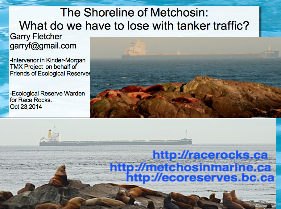
This  recent cover story by Lovel Pratt in the Whatcom Watch Onlinehttp://www.whatcomwatch.org/php/WW_open.php?id=1795 is well worth reading for Metchosin residents .
Examples it has stated:

  • “The consequences are huge: The Department of Ecology(Washington State)  estimates that a major oil spill in the state would cost 165,000 jobs and $10.8 billion in annual economic activity.
  • However, these figures are undervalued because, in addition to being two years outdated, this estimate does not include any costs associated with the impacts of oil spills to privately owned shoreline and water-view properties.”
  • “Property owners may be required to evacuate if faced with fire danger and/or air pollution from emissions of benzene and other volatile organic compounds. If evacuation is not required, shoreline and water access could be cut back or prohibited. Water views would be spoiled by oil slicks and noisy cleanup operations, and oiled shorelines would likely be mechanically cleaned by pressure washing and bulldozing.–Property owners also face losses to assessed values. A study conducted in British Columbia revealed that privately owned properties can lose from 10-40 percent in value, and even properties near spills that are not directly affected can lose value by association.”
  • “Typical homeowner’s insurance would not provide compensation in the event of an oil spill. Pollutants are excluded in property policies unless the coverage is specifically defined to include the pollutant. According to my local insurance agent, unless a homeowner’s policy specifically covers oil spills, there would be no compensation for loss of use or loss of value resulting directly or indirectly from an oil spill. Further, it would be both difficult and most likely quite expensive to find such coverage.
  • “The Exxon Valdez oil spill, which hasn’t been completely cleaned up after 25 years, still has continuous and compounding environmental and economic impacts.8 Washington State can’t afford that tragedy. The 165,000 jobs and $10.8 billion in annual economic activity don’t accurately estimate the costs that such a catastrophe would have on the state.”
  • See the well-referenced article here: http://www.whatcomwatch.org/php/WW_open.php?id=1795
  • Thanks to Andy MacKinnon for pointing to this.

Letter of Support for the BC Government Motion of Dec 5 from the Board of FER

Our shoreline and Race Rocks Ecological reserve are  at risk of an oil spill. Metchosin resident Garry Fletcher and Victoria resident Mike Fenger have been Intervenors in the NEB Kinder Morgan/ Trans Mountain Pipeline Proposal Hearing  on behalf of the Board of Friends of Ecological Reserves. The letter linked here was sent in support of the Province of British Columbia’s  attempts to have full disclosure of the emergency Plans of the WCMRC (Western Canada Marine Response Corporation). ( which happens to be over 50% owned by Kinder Morgan…)

RE: Notice of Motion by the Province of British Columbia submitted December 5, 2014 OH -01- 2014 Trans Mountain Pipeline ULC (“Trans Mountain”) Trans Mountain Expansion Project (the “Project”) File Number OF-Fac-Oil-T260-2013-03 02

As an Intervenor in the above mentioned application, the Board of Friends of Ecological Reserve’s (Board of FER )provides the following comments in support for BC’s Motion submitted by the Province of British Columbia on December 5, 2014.
Please be advised that the Board of FER supports the order sought in the Province of British Columbia’s Notice of Motion dated December 5, 2014:————-

The complete text of this letter can be viewed here on the National Energy Board Website .

 Internal FER website link to this pdf:

Special Report: Tar Sands Reporting Project

Ed note: This link  is included here as an ongoing record of the problem associated with the tar sands project which has resulted in the Kinder Morgan Pipeline Expansion and the Northern Gateway Project of Enbridge.   It is an indication of the state of the Social License Oil companies have achieved with such projects.

mine-site-oil-sands_N3G4651_webSpecial Report: Tar Sands Reporting Project
From the Vancouver Observer: “
Our award-winning team’s crowd-funded series on the people, places and conflicts associated with Canada’s tar sands.”

Coastal erosion as a sediment source – implications for shoreline management

Puget Sound Feeder Bluffs: Coastal erosion as a sediment source and its implications for shoreline management Shipman et al 2014 .
See the PDF: pugetsoundhardening1406016

feederbluffreport

This report examines the role of eroding bluffs as a source of sediment for Puget Sound beaches and includes a review of related geology and coastal processes. It summarizes recent mapping of feeder bluffs and examines ways in which this information can be used to improve shoreline management.

This report is one part of a larger project on Puget Sound feeder bluffs that also includes maps and a series of web pages that cover much of the material in this report. The project was funded by EPA and the WA Department of Fish and Wildlife. Hugh Shipman and colleagues  published this  important report on feeder bluffs processes and management. Coastal Watershed Index of Port Angeles has been working on the complex and critical topic of feeder bluff management for over a decade. One of their biggest challenges is imparting the critical and unique elements of feeder bluff function and management (including the reality that there are no ‘soft armoring’ techniques appropriate for this land form ). This report provides scientific and management focus specifically to feeder bluffs of the Salish Sea- it’s long overdue.


feederbluffmaps


Part 2 is of the maps of feeder bluffs of Puget sound:


Accessed Nov 4, 2014 at :
https://fortress.wa.gov/ecy/publications/SummaryPages
Maps:
https://fortress.wa.gov/ecy/publications/publications/1406016part2.pdf/1406016.html.

See More on Feeder Bluff mapping:


The Shoreline of Metchosin: What do we have to lose with tanker traffic

Along the shoreline of Metchosin and underwater we have ecosystems which are at risk of being heavily impacted in the event of an impending oil spill catastrophe given all the proposed projects which will increase ship traffic to unacceptable levels in the Strait of Juan de Fuca. The presentation by Garry Fletcher linked here was done on the evening of October 23rd, 2014 at the Metchosin Community Hall organized by Karyn Woodland and the local Dogwood Initiative Group. ( NOTE: comments are included under the images and all images are copyright of the photographers who took them, John Harper(GeoBC); the ecoguardians at Race Rocks: Ryan Murphy, Raisa Mirza, Alex Fletcher, Anne Stewart, Adam Harding, Mike Robinson and Courtenay Edwards, and myself. The graphics from the first part on Oil Spill Risk are from  posts of Nov.4 on Oil Spill Risks
Link to a description of the three presentations to the Town hall meeting by Kai Nagata of the Dogwood Initiative, Andrew Weaver, Green Party MLA for Oak Bay and Intervenor in the Kinder Morgan hearings, and Garry Fletcher, Intervenor for the Board of Friends of Ecological Reserves in the Kinder-Morgan / Trans Mountain Expansion project hearings. gfpresent

New Publication on Shoreline Erosion Control out of Washington State

I attended the Salish Sea Ecosystem Conference in Seattle several weeks ago and one of the sessions I attended was delivered by the presenter of the following report.
In  Puget Sound there is no hesitation in bsing very specific on what needs to be done about controlling the impact of humans on the shoreline as they have a long history of making a real mess of many kilometers of shoreline.

http://wdfw.wa.gov/publications/01583/


Update on the Kinder Morgan TMX National Energy Board Hearings

Our coastline in Metchosin is highly exposed to the potential risks from the increase in tanker traffic that will come if the Kinder Morgan/ Trans Mountain Pipeline Expansion s allowed to proceed. (400 Aframax size tankers per year) In order to provide access to the Information requests from the over 400 intervenors which are available on the NEB website, the following link is provided. The Board of the Friends of Ecological Reserves has posted their first set of Information Requests to the National Energy Board and Kinder Morgan as Intervenors in the Trans Mountain Pipeline Expansion Project . Their concerns focus on the Ecological reserves of Southern Vancouver Island such as Race Rocks . See this link with a further link to all intervenors Information requests. kmstudyarea-1

B.C. coast, St. Lawrence Estuary most at Risk for Major Marine Oil Spill: Report

Adapted from the Times Colonist at this link:
http://www.timescolonist.com/opinion/b-c-coast-st-lawrence-estuary-most-at-risk-for-major-marine-oil-spill-report-1.806714

The Canadian Press
January 29, 2014 01:24 PM  

OTTAWA — A government-commissioned risk analysis says the coast of southern British Columbia and the Gulf of St. Lawrence are the Canadian areas most vulnerable marine oil spills and among the most likely for a major spill to occur.

The findings will add to the debate over several pipeline proposals — including two in B.C. that the report says will substantially increase marine risks.

The 256-page study, delivered this month to Transport Canada, looks at the risks associated with marine oil spills south of the 60th parallel under current shipping volumes.

race-rocks-lighthouseIt identifies the southern tip of Vancouver Island, the Cabot Strait off Newfoundland, the eastern coast of Cape Breton Island and the Gulf of St. Lawrence as the most probable areas for a major oil spill.

But the study also assesses the potential impact of four proposed pipeline projects, including the Northern Gateway Pipeline to Kitimat and Kinder Morgan’s plan to almost triple its Trans Mountain line into Vancouver.

The report says the Kinder Morgan proposal would essentially double oil traffic in an already vulnerable marine environment — with a corresponding increase in spill frequency — while the Northern Gateway marine route would turn what are currently very low, near-shore risks into very high risks.

The study found that reversing Enbridge’s Line 9 to carry Western Canadian crude to refineries in Montreal and Quebec City would actually lower marine spill risks, as it would reduce oil imports through the sensitive Gulf of St. Lawrence.

And the study found that the proposed Energy East Pipeline to St. John, N.B., would likely be a wash, reducing shipping imports but increasing oil exports to leave the overall marine risk about where it is now.

© Copyright Times Colonist

Posts on this website about the risk of oil spills on Metchosin’s shores:

Posts on the Ecological Reserves website about the threat of Oil Spills from Tanker Traffic

Posts on the Race Rocks website about the Risk from Increased Tanker Traffic

See the following posts for further information on Tanker traffic off our shores:

figure-3-overall-risks-oil- spills

 Review of Canada’s Ship-Source Oil-Spill Preparedness and response Regime: 


Application to NEB by Board of Friends of Ecological Reserves

mapandships
 Ship traffic in the Strait of Juan de Fuca